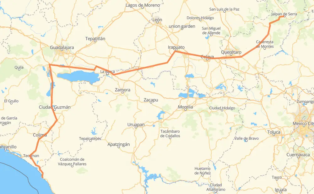
Distance between Jalpan de Serra and San Juan de Alima
The distance from Jalpan de Serra to San Juan de Alima is 499 miles by road including 257 miles on motorways. Road takes approximately 9 hours and 20 minutes and goes through Querétaro, Celaya, Salamanca, Irapuato and Colima.
| Shortest distance by air | 328 mi ✈️ |
| Car route length | 499 mi 🚗 |
| Driving time | 9 h 20 min |
| Fuel amount | 17 gal |
| Fuel cost | 66.7 USD |
| Toll roads cost | 328 + ? MXN |
| Point | Distance | Time | Fuel | |
| Jalpan de Serra | 0 mi | 00 min | 0.0 gal | |
|
MEX 120 118 mi, 2 h 35 min
|
||||
| Querétaro | 118 mi | 2 h 35 min | 3.9 gal | |
|
MEX 57 MEX 45D 21 mi, 19 min
|
||||
| Apaseo el Grande | 139 mi | 2 h 54 min | 4.6 gal | |
|
MEX 45D 7 mi, 06 min
|
||||
| Celaya | 146 mi | 3 h 00 min | 4.9 gal | |
|
MEX 45D 24 mi, 24 min
|
||||
| Salamanca | 170 mi | 3 h 25 min | 5.7 gal | |
|
MEX 45D 5 mi, 06 min
|
||||
| Cárdenas | 175 mi | 3 h 31 min | 5.9 gal | |
|
MEX 45D 7 mi, 07 min
|
||||
| Irapuato | 183 mi | 3 h 39 min | 6.1 gal | |
|
MEX 90 15 mi, 16 min
|
||||
| Abasolo | 197 mi | 3 h 55 min | 6.4 gal | |
|
MEX 90 MEX 54D 247 mi, 4 h 19 min
|
||||
| Colima | 444 mi | 8 h 15 min | 15.0 gal | |
|
MEX 54D MEX 200 59 mi, 1 h 04 min
|
||||
| San Juan de Alima | 503 mi | 9 h 19 min | 16.9 gal | |
Frequently Asked Questions
How many toll booths are there from Jalpan de Serra to San Juan de Alima?
There are 8 toll booths between Jalpan de Serra and San Juan de Alima: Sayula, Chapala, Ocotlán, Vista Hermosa, Salamanca, Cerro Gordo, Querétaro 6 and Libramiento de La Piedad.
How much does the toll booths cost from Jalpan de Serra to San Juan de Alima?
Toll roads cost: Querétaro 6 (82 MXN) + Cerro Gordo (?) + Salamanca (83 MXN) + Libramiento de La Piedad (?) + Vista Hermosa (32 MXN) + Ocotlán (56 MXN) + Chapala (75 MXN) + Sayula (?) = 328 + ? MXN
How much does it cost to drive from Jalpan de Serra to San Juan de Alima?
Fuel cost: 66.7 USD
This fuel cost is calculated as: (Route length 499 mi) / (Fuel consumption 29.4 mpg) * (Fuel price 3.93 USD / gal)
You can adjust fuel consumption and fuel price here.
Toll roads cost: 328 + ? MXN
How long is a car ride from Jalpan de Serra to San Juan de Alima?
Driving time: 9 h 20 min
This time is calculated for driving at the maximum permitted speed, taking into account traffic rules restrictions.
- 70 mi with a maximum speed 68 mph = 1 h 1 min
- 117 mi with a maximum speed 62 mph = 1 h 52 min
- 23 mi with a maximum speed 56 mph = 24 min
- 99 mi with a maximum speed 56 mph = 1 h 45 min
- 152 mi with a maximum speed 50 mph = 3 h 3 min
- 4 mi with a maximum speed 43 mph = 6 min
- 29 mi with a maximum speed 37 mph = 46 min
- 4 mi with a maximum speed 31 mph = 8 min
- 4 mi with a maximum speed 25 mph = 9 min
The calculated driving time does not take into account intermediate stops and traffic jams.
How far is Jalpan de Serra to San Juan de Alima by land?
The distance between Jalpan de Serra and San Juan de Alima is 499 mi by road including 257.2 mi on motorways.
Precise satellite coordinates of highways were used for this calculation. The start and finish points are the centers of Jalpan de Serra and San Juan de Alima respectively.
How far is Jalpan de Serra to San Juan de Alima by plane?
The shortest distance (air line, as the crow flies) between Jalpan de Serra and San Juan de Alima is 328.1 mi.
This distance is calculated using the Haversine formula as a great-circle distance between two points on the surface of a sphere. The start and finish points are the centers of Jalpan de Serra and San Juan de Alima respectively. Actual distance between airports may be different.
How many hours is Jalpan de Serra from San Juan de Alima by plane?
Boeing 737 airliner needs 39 min to cover the distance of 328 mi at a cruising speed of 497 mph.
Small plane "Cessna 172" needs 2 h 24 min to flight this distance at average speed of 136 mph.
This time is approximate and do not take into account takeoff and landing times, airport location and other real world factors.
How long is a helicopter ride from Jalpan de Serra to San Juan de Alima?
Fast helicopter "Eurocopter AS350" or "Hughes OH-6 Cayuse" need 2 h 12 min to cover the distance of 328 mi at a cruising speed of 149 mph.
Popular "Robinson R44" needs 2 h 30 min to flight this distance at average speed of 130 mph.
This time is approximate and do not take into account takeoff and landing times, aerodrome location and other real world factors.
What city is halfway between Jalpan de Serra and San Juan de Alima?
The halfway point between Jalpan de Serra and San Juan de Alima is Santa Cecilia. It is located about 2 mi from the exact midpoint by road.
The distance from Santa Cecilia to Jalpan de Serra is 247 mi and driving will take about 4 h 50 min. The road between Santa Cecilia and San Juan de Alima has length 252 mi and will take approximately 4 h 29 min.
The other cities located close to halfway point:
Where is Jalpan de Serra in relation to San Juan de Alima?
Jalpan de Serra is located 328 mi north-east of San Juan de Alima.
Jalpan de Serra has geographic coordinates: latitude 21.21941, longitude -99.47441.
San Juan de Alima has geographic coordinates: latitude 18.58257, longitude -103.67088.
Which highway goes from Jalpan de Serra to San Juan de Alima?
The route from Jalpan de Serra to San Juan de Alima follows MEX 54D.
Other minor sections pass along the road:
- MEX 45D: 60 mi
- MEX 120: 56 mi
- QRO 100: 48 mi
- MEX 90: 45 mi
- MEX 200: 32 mi
- MEX 35: 29 mi
- MEX 110D: 24 mi
- MEX GUA 10D: 22 mi
- MEX 15D: 22 mi
- MEX 110: 15 mi
- MEX 90D: 13 mi
- MEX 45: 9 mi
- MEX 57: 7 mi
- MEX 45: 3 mi
- JAL 122: 2 mi
- MEX 80: 2 mi
- MEX 15: 1 mi