Distance between Juína and Lábrea
The distance from Juína to Lábrea is 839 miles by road. Road takes approximately 17 hours and 1 minute and goes through Ariquemes, Porto Velho, Vilhena, Pimenta Bueno, Cacoal, Presidente Médici and Ouro Preto do Oeste.
| Shortest distance by air | 502 mi ✈️ |
| Car route length | 838.9 mi 🚗 |
| Driving time | 17 h 1 min |
| Fuel amount | 28.5 gal |
| Fuel cost | 112.2 USD |
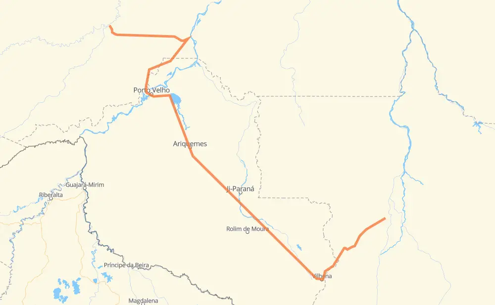
| Point | Distance | Time | Fuel | |
| -11.42309, -58.75702 | 0 mi | 00 min | 0.0 gal | |
|
BR-174 151 mi, 3 h 00 min
|
||||
| Vilhena | 151 mi | 3 h 00 min | 9.8 gal | |
|
BR-364 50 mi, 57 min
|
||||
| São Lourenço | 201 mi | 3 h 58 min | 11.0 gal | |
|
BR-364 43 mi, 52 min
|
||||
| Pimenta Bueno | 244 mi | 4 h 50 min | 12.5 gal | |
|
BR-364 41 mi, 47 min
|
||||
| Cacoal | 285 mi | 5 h 38 min | 14.4 gal | |
|
BR-364 55 mi, 1 h 01 min
|
||||
| Presidente Médici | 341 mi | 6 h 39 min | 16.1 gal | |
|
BR-364 37 mi, 43 min
|
||||
| Ouro Preto do Oeste | 377 mi | 7 h 22 min | 17.6 gal | |
|
BR-364 73 mi, 2 h 00 min
|
||||
| Ariquemes | 451 mi | 9 h 23 min | 19.7 gal | |
|
BR-364 135 mi, 2 h 36 min
|
||||
| Porto Velho | 586 mi | 11 h 59 min | 24.8 gal | |
|
BR-319 2 mi, 02 min
|
||||
| Pedrinhas | 588 mi | 12 h 02 min | 24.9 gal | |
|
BR-319 75 mi, 1 h 29 min
|
||||
| Renascer | 662 mi | 13 h 31 min | 26.4 gal | |
|
BR-319 BR-230 177 mi, 3 h 30 min
|
||||
| -7.26137, -64.79245 | 839 mi | 17 h 01 min | 33.4 gal | |
Frequently Asked Questions
How much does it cost to drive from Juína to Lábrea?
Fuel cost: 112.2 USD
This fuel cost is calculated as: (Route length 838.9 mi) / (Fuel consumption 29.4 mpg) * (Fuel price 3.93 USD / gal)
You can adjust fuel consumption and fuel price here.
How long is a car ride from Juína to Lábrea?
Driving time: 17 h 1 min
This time is calculated for driving at the maximum permitted speed, taking into account traffic rules restrictions.
- 247 mi with a maximum speed 56 mph = 4 h 25 min
- 533 mi with a maximum speed 50 mph = 10 h 42 min
- 1 mi with a maximum speed 37 mph = 1 min
- 58 mi with a maximum speed 31 mph = 1 h 52 min
The calculated driving time does not take into account intermediate stops and traffic jams.
How far is Juína to Lábrea by land?
The distance between Juína and Lábrea is 838.9 mi by road.
Precise satellite coordinates of highways were used for this calculation. The start and finish points are the centers of Juína and Lábrea respectively.
How far is Juína to Lábrea by plane?
The shortest distance (air line, as the crow flies) between Juína and Lábrea is 502.1 mi.
This distance is calculated using the Haversine formula as a great-circle distance between two points on the surface of a sphere. The start and finish points are the centers of Juína and Lábrea respectively. Actual distance between airports may be different.
How many hours is Juína from Lábrea by plane?
Boeing 737 airliner needs 1 h to cover the distance of 502 mi at a cruising speed of 497 mph.
Small plane "Cessna 172" needs 3 h 40 min to flight this distance at average speed of 136 mph.
This time is approximate and do not take into account takeoff and landing times, airport location and other real world factors.
How long is a helicopter ride from Juína to Lábrea?
Fast helicopter "Eurocopter AS350" or "Hughes OH-6 Cayuse" need 3 h 22 min to cover the distance of 502 mi at a cruising speed of 149 mph.
Popular "Robinson R44" needs 3 h 50 min to flight this distance at average speed of 130 mph.
This time is approximate and do not take into account takeoff and landing times, aerodrome location and other real world factors.
What city is halfway between Juína and Lábrea?
The halfway point between Juína and Lábrea is Ariquemes. It is located about 32 mi from the exact midpoint by road.
The distance from Ariquemes to Juína is 451 mi and driving will take about 9 h 23 min. The road between Ariquemes and Lábrea has length 388 mi and will take approximately 7 h 38 min.
The other cities located close to halfway point:
Where is Juína in relation to Lábrea?
Juína is located 502 mi south-east of Lábrea.
Juína has geographic coordinates: latitude -11.42309, longitude -58.75702.
Lábrea has geographic coordinates: latitude -7.26137, longitude -64.79245.
Which highway goes from Juína to Lábrea?
The route from Juína to Lábrea follows BR-364, BR-174, BR-230, BR-319, MT-319.