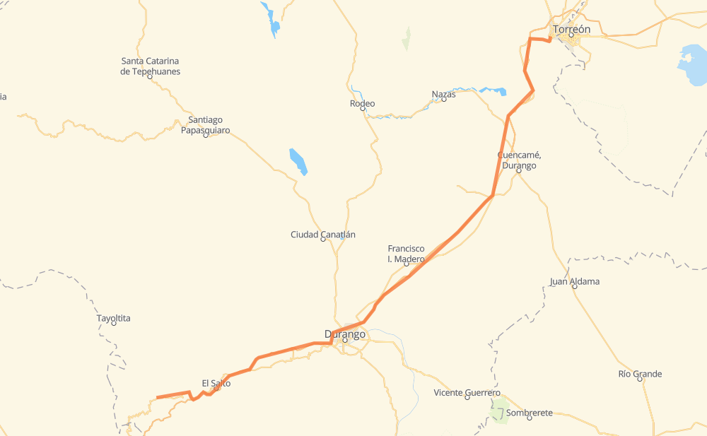
Distance between La Ciudad and Ciudad Lerdo
The distance from La Ciudad to Ciudad Lerdo is 224 miles by road including 131 miles on motorways. Road takes approximately 3 hours and 46 minutes and goes through El Salto, Ignacio Ramirez, Yerbanis and La Lomas.
| Shortest distance by air | 185 mi ✈️ |
| Car route length | 224.3 mi 🚗 |
| Driving time | 3 h 46 min |
| Fuel amount | 7.6 gal |
| Fuel cost | 30 USD |
| Toll roads cost | 167 + ? MXN |
| Point | Distance | Time | Fuel | |
| La Ciudad | 0 mi | 00 min | 0.0 gal | |
|
MEX 40 12 mi, 14 min
|
||||
| Las Adjuntas | 12 mi | 14 min | 0.2 gal | |
|
MEX 40 MEX 40D 15 mi, 14 min
|
||||
| El Salto | 27 mi | 29 min | 0.8 gal | |
|
MEX 40D 14 mi, 16 min
|
||||
| Llano Grande | 40 mi | 46 min | 1.3 gal | |
|
MEX 40D 91 mi, 1 h 34 min
|
||||
| Ignacio Ramirez | 131 mi | 2 h 20 min | 4.4 gal | |
|
MEX 40D 22 mi, 18 min
|
||||
| Yerbanis | 153 mi | 2 h 39 min | 5.1 gal | |
|
MEX 40D 25 mi, 22 min
|
||||
| Vista Hermosa | 178 mi | 3 h 02 min | 5.8 gal | |
|
MEX 40D 14 mi, 12 min
|
||||
| Margarito Machado | 193 mi | 3 h 15 min | 6.3 gal | |
|
MEX 40D 14 mi, 11 min
|
||||
| La Lomas | 206 mi | 3 h 27 min | 6.8 gal | |
|
MEX 40D MEX 40 18 mi, 18 min
|
||||
| Ciudad Lerdo | 224 mi | 3 h 46 min | 7.5 gal | |
Frequently Asked Questions
How many toll booths are there from La Ciudad to Ciudad Lerdo?
There are 6 toll booths between La Ciudad and Ciudad Lerdo: León Guzmán, Cuencame, Yerbanis, Durango, Durango 95 and Llano Grande.
How much does the toll booths cost from La Ciudad to Ciudad Lerdo?
Toll roads cost: Llano Grande (100 MXN) + Durango 95 (67 MXN) + Durango (?) + Yerbanis (?) + Cuencame (?) + León Guzmán (?) = 167 + ? MXN
How much does it cost to drive from La Ciudad to Ciudad Lerdo?
Fuel cost: 30 USD
This fuel cost is calculated as: (Route length 224.3 mi) / (Fuel consumption 29.4 mpg) * (Fuel price 3.93 USD / gal)
You can adjust fuel consumption and fuel price here.
Toll roads cost: 167 + ? MXN
How long is a car ride from La Ciudad to Ciudad Lerdo?
Driving time: 3 h 46 min
This time is calculated for driving at the maximum permitted speed, taking into account traffic rules restrictions.
- 126 mi with a maximum speed 68 mph = 1 h 51 min
- 65 mi with a maximum speed 56 mph = 1 h 9 min
- 22 mi with a maximum speed 56 mph = 23 min
- 2 mi with a maximum speed 50 mph = 3 min
- 6 mi with a maximum speed 37 mph = 8 min
- 1 mi with a maximum speed 25 mph = 1 min
- 1 mi with a maximum speed 12 mph = 2 min
- 1 mi with a maximum speed 6 mph = 4 min
The calculated driving time does not take into account intermediate stops and traffic jams.
How far is La Ciudad to Ciudad Lerdo by land?
The distance between La Ciudad and Ciudad Lerdo is 224.3 mi by road including 131.1 mi on motorways.
Precise satellite coordinates of highways were used for this calculation. The start and finish points are the centers of La Ciudad and Ciudad Lerdo respectively.
How far is La Ciudad to Ciudad Lerdo by plane?
The shortest distance (air line, as the crow flies) between La Ciudad and Ciudad Lerdo is 184.5 mi.
This distance is calculated using the Haversine formula as a great-circle distance between two points on the surface of a sphere. The start and finish points are the centers of La Ciudad and Ciudad Lerdo respectively. Actual distance between airports may be different.
How many hours is La Ciudad from Ciudad Lerdo by plane?
Boeing 737 airliner needs 22 min to cover the distance of 185 mi at a cruising speed of 497 mph.
Small plane "Cessna 172" needs 1 h 21 min to flight this distance at average speed of 136 mph.
This time is approximate and do not take into account takeoff and landing times, airport location and other real world factors.
How long is a helicopter ride from La Ciudad to Ciudad Lerdo?
Fast helicopter "Eurocopter AS350" or "Hughes OH-6 Cayuse" need 1 h 14 min to cover the distance of 185 mi at a cruising speed of 149 mph.
Popular "Robinson R44" needs 1 h 24 min to flight this distance at average speed of 130 mph.
This time is approximate and do not take into account takeoff and landing times, aerodrome location and other real world factors.
What city is halfway between La Ciudad and Ciudad Lerdo?
The halfway point between La Ciudad and Ciudad Lerdo is Los Caballeros. It is located about 16 mi from the exact midpoint by road.
The distance from Los Caballeros to La Ciudad is 96 mi and driving will take about 1 h 49 min. The road between Los Caballeros and Ciudad Lerdo has length 128 mi and will take approximately 1 h 56 min.
The other cities located close to halfway point:
Where is La Ciudad in relation to Ciudad Lerdo?
La Ciudad is located 185 mi south-west of Ciudad Lerdo.
La Ciudad has geographic coordinates: latitude 23.73215, longitude -105.69008.
Ciudad Lerdo has geographic coordinates: latitude 25.53664, longitude -103.52525.
Which highway goes from La Ciudad to Ciudad Lerdo?
The route from La Ciudad to Ciudad Lerdo follows MEX 40D.
Other minor sections pass along the road:
- MEX 49D: 43 mi
- MEX 40: 39 mi
- MEX 49: 7 mi