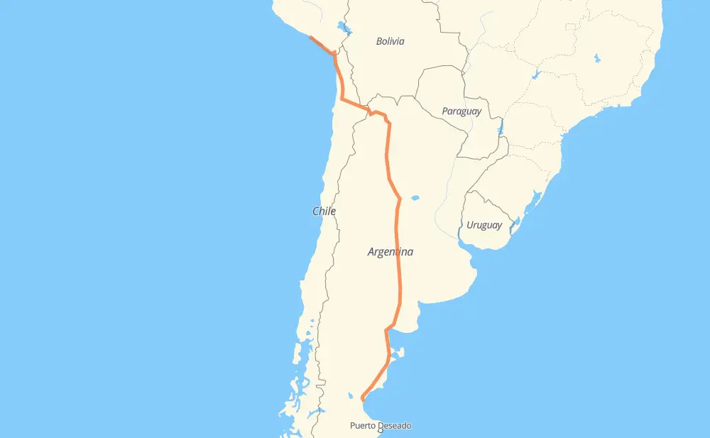
The distance from La Punta to Comodoro Rivadavia is 2,671 miles by road including 61 miles on motorways. Road takes approximately 49 hours and 59 minutes and goes through Arica, Calama, San Salvador de Jujuy, San Miguel de Tucumán, Córdoba, Río Cuarto and Santa Rosa.
You can adjust fuel consumption and fuel price here.
How long is a car ride from La Punta to Comodoro Rivadavia?
Driving time:
49 h 59 min
This time is calculated for driving at the maximum permitted speed, taking into account traffic rules restrictions.
26 mi with a maximum speed 68 mph = 23 min
17 mi with a maximum speed 62 mph = 16 min
1,805 mi with a maximum speed 56 mph = 32 h 14 min
757 mi with a maximum speed 50 mph = 15 h 13 min
1 mi with a maximum speed 43 mph = 1 min
50 mi with a maximum speed 37 mph = 1 h 20 min
9 mi with a maximum speed 31 mph = 16 min
4 mi with a maximum speed 25 mph = 11 min
The calculated driving time does not take into account intermediate stops and traffic jams.
How far is La Punta to Comodoro Rivadavia by land?
The distance between La Punta and Comodoro Rivadavia is 2,670.7 mi by road including 60.9 mi on motorways.
Precise satellite coordinates of highways were used for this calculation. The start and finish points are the centers of La Punta and Comodoro Rivadavia respectively.
How far is La Punta to Comodoro Rivadavia by plane?
The shortest distance (air line, as the crow flies) between La Punta and Comodoro Rivadavia is 2,041.2 mi.
This distance is calculated using the Haversine formula as a great-circle distance between two points on the surface of a sphere. The start and finish points are the centers of La Punta and Comodoro Rivadavia respectively. Actual distance between airports may be different.
How many hours is La Punta from Comodoro Rivadavia by plane?
Boeing 737 airliner needs 4 h 6 min to cover the distance of 2,041 mi at a cruising speed of 497 mph.
Small plane "Cessna 172" needs 14 h 55 min to flight this distance at average speed of 136 mph.
This time is approximate and do not take into account takeoff and landing times, airport location and other real world factors.
How long is a helicopter ride from La Punta to Comodoro Rivadavia?
Fast helicopter "Eurocopter AS350" or "Hughes OH-6 Cayuse" need 13 h 41 min to cover the distance of 2,041 mi at a cruising speed of 149 mph.
Popular "Robinson R44" needs 15 h 38 min to flight this distance at average speed of 130 mph.
This time is approximate and do not take into account takeoff and landing times, aerodrome location and other real world factors.
What city is halfway between La Punta and Comodoro Rivadavia?
The halfway point between La Punta and Comodoro Rivadavia is Quirós. It is located about 13 mi from the exact midpoint by road.
The distance from Quirós to La Punta is 1,348 mi and driving will take about 25 h 48 min. The road between Quirós and Comodoro Rivadavia has length 1,322 mi and will take approximately 24 h 10 min.
The other cities located close to halfway point:
Frías is in 1,315 mi from La Punta and 1,356 mi from Comodoro Rivadavia
Lavalle is in 1,298 mi from La Punta and 1,373 mi from Comodoro Rivadavia
San Pedro is in 1,289 mi from La Punta and 1,382 mi from Comodoro Rivadavia
Where is La Punta in relation to Comodoro Rivadavia?
La Punta is located 2,041 mi north of Comodoro Rivadavia.
La Punta has geographic coordinates: latitude -16.65203, longitude -72.68258.
Comodoro Rivadavia has geographic coordinates: latitude -45.86534, longitude -67.48075.
Which highway goes from La Punta to Comodoro Rivadavia?
The route from La Punta to Comodoro Rivadavia follows RN3, 5, RN35, RN9, PE-1SD, RN157, RN52, RN251, RN36, RN60, RN34, 27-CH, RN154.