Distance between La Tour-de-Peilz and Corsy
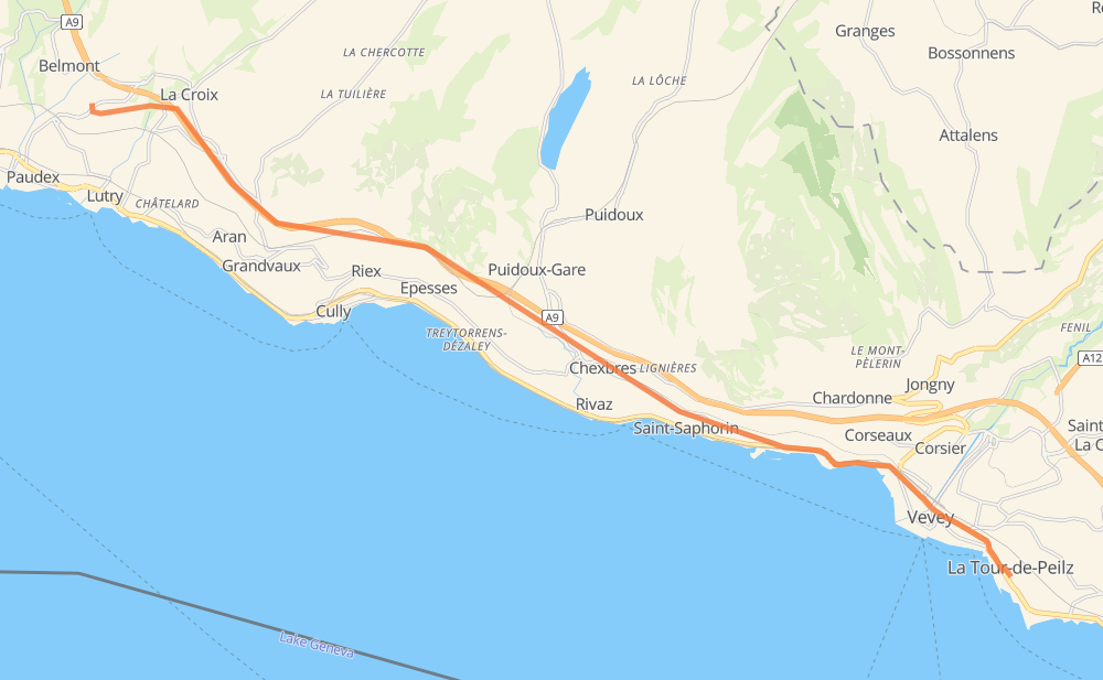
The distance from La Tour-de-Peilz to Corsy is 10 miles by road including 5 miles on motorways. Road takes approximately 13 minutes and goes through Vevey, Saint-Saphorin, Chexbres, Puidoux-Gare, Epesses and La Croix.
| Shortest distance by air | 9 mi ✈️ |
| Car route length | 9.9 mi 🚗 |
| Driving time | 13 min |
| Fuel amount | 0.3 gal |
| Fuel cost | 1.4 USD |
| Point | Distance | Time | Fuel | |
| La Tour-de-Peilz | 0 mi | 00 min | 0.0 gal | |
|
9 1 mi, 01 min
|
||||
| Vevey | 1 mi | 01 min | 0.0 gal | |
|
9 2 mi, 03 min
|
||||
| Saint-Saphorin | 4 mi | 05 min | 0.1 gal | |
|
140 1 mi, 01 min
|
||||
| Chexbres | 4 mi | 06 min | 0.1 gal | |
|
140 1 mi, 01 min
|
||||
| Puidoux-Gare | 6 mi | 08 min | 0.2 gal | |
|
A9 1 mi, 00 min
|
||||
| Epesses | 6 mi | 09 min | 0.2 gal | |
|
A9 3 mi, 02 min
|
||||
| La Croix | 9 mi | 12 min | 0.3 gal | |
|
A9 1 mi, 01 min
|
||||
| Corsy | 10 mi | 13 min | 0.3 gal | |
Frequently Asked Questions
How much does it cost to drive from La Tour-de-Peilz to Corsy?
Fuel cost: 1.4 USD
This fuel cost is calculated as: (Route length 9.9 mi) / (Fuel consumption 29.4 mpg) * (Fuel price 3.93 USD / gal)
You can adjust fuel consumption and fuel price here.
How long is a car ride from La Tour-de-Peilz to Corsy?
Driving time: 13 min
This time is calculated for driving at the maximum permitted speed, taking into account traffic rules restrictions.
- 3 mi with a maximum speed 62 mph = 3 min
- 3 mi with a maximum speed 50 mph = 3 min
- 1 mi with a maximum speed 37 mph = 1 min
- 2 mi with a maximum speed 31 mph = 3 min
The calculated driving time does not take into account intermediate stops and traffic jams.
How far is La Tour-de-Peilz to Corsy by land?
The distance between La Tour-de-Peilz and Corsy is 9.9 mi by road including 5 mi on motorways.
Precise satellite coordinates of highways were used for this calculation. The start and finish points are the centers of La Tour-de-Peilz and Corsy respectively.
What city is halfway between La Tour-de-Peilz and Corsy?
The halfway point between La Tour-de-Peilz and Corsy is Puidoux-Gare. It is located about 1 mi from the exact midpoint by road.
The distance from Puidoux-Gare to La Tour-de-Peilz is 6 mi and driving will take about 8 min. The road between Puidoux-Gare and Corsy has length 5 mi and will take approximately 5 min.
The other cities located close to halfway point:
Where is La Tour-de-Peilz in relation to Corsy?
La Tour-de-Peilz is located 9 mi south-east of Corsy.
La Tour-de-Peilz has geographic coordinates: latitude 46.45377, longitude 6.85693.
Corsy has geographic coordinates: latitude 46.51518, longitude 6.68433.
Which highway goes from La Tour-de-Peilz to Corsy?
The route from La Tour-de-Peilz to Corsy follows A9.
Other minor sections pass along the road:
- 140: 2 mi
- 9: 2 mi