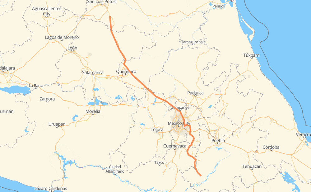
Distance between Las Enramadas and Ciudad de Chiautla de Tapia
The distance from Las Enramadas to Ciudad de Chiautla de Tapia is 345 miles by road including 265 miles on motorways. Road takes approximately 6 hours and 13 minutes and goes through San Juan del Rio, Delegación de La Pila, Santa María del Río, Parque Industrial Queretaro, Ecatepec de Morelos, Depósito de Evaporación Solar "El Caracol" and Chimalhuacán.
| Shortest distance by air | 285 mi ✈️ |
| Car route length | 344.9 mi 🚗 |
| Driving time | 6 h 13 min |
| Fuel amount | 11.7 gal |
| Fuel cost | 46.1 USD |
| Toll roads cost | 496 + ? MXN |
| Point | Distance | Time | Fuel | |
| Las Enramadas | 0 mi | 00 min | 0.0 gal | |
|
MEX 57 87 mi, 1 h 28 min
|
||||
| Parque Industrial Queretaro | 87 mi | 1 h 28 min | 2.9 gal | |
|
MEX 57 MEX 57D 45 mi, 48 min
|
||||
| San Juan del Rio | 132 mi | 2 h 16 min | 4.3 gal | |
|
MEX 57 MEX 57D 85 mi, 1 h 26 min
|
||||
| Ecatepec de Morelos | 217 mi | 3 h 43 min | 7.3 gal | |
|
57D 6 mi, 07 min
|
||||
| Depósito de Evaporación Solar "El Caracol" | 223 mi | 3 h 50 min | 7.5 gal | |
|
57D 11 mi, 12 min
|
||||
| Chimalhuacán | 234 mi | 4 h 02 min | 7.8 gal | |
|
EXT 16 mi, 16 min
|
||||
| Ixtapaluca | 250 mi | 4 h 19 min | 8.4 gal | |
|
EXT 4 mi, 04 min
|
||||
| Chalco de Díaz Covarrubias | 254 mi | 4 h 23 min | 8.6 gal | |
|
MEX 115 22 mi, 24 min
|
||||
| Tepetlixpa | 275 mi | 4 h 48 min | 9.1 gal | |
|
MEX 160 70 mi, 1 h 24 min
|
||||
| Ciudad de Chiautla de Tapia | 345 mi | 6 h 13 min | 11.7 gal | |
Frequently Asked Questions
How many toll booths are there from Las Enramadas to Ciudad de Chiautla de Tapia?
There are 8 toll booths between Las Enramadas and Ciudad de Chiautla de Tapia: Chichimequillas, Palmillas, Circuito Exterior Mexiquense T-0 Jorobas, Circuito Exterior Mexiquense T-1 Tultepec, Circuito Exterior Mexiquense T-3 Nabor Carrillo, Circuito Exterior Mexiquense T-7 Texcoco, Circuito Exterior Mexiquense T-4 Chalco and Circuito Exterior Mexiquense T-2 Las Americas Conmex.
How much does the toll booths cost from Las Enramadas to Ciudad de Chiautla de Tapia?
Toll roads cost: Chichimequillas (51 MXN) + Palmillas (89 MXN) + Circuito Exterior Mexiquense T-0 Jorobas (126 MXN) + Circuito Exterior Mexiquense T-1 Tultepec (84 MXN) + Circuito Exterior Mexiquense T-2 Las Americas Conmex (60 MXN) + Circuito Exterior Mexiquense T-3 Nabor Carrillo (?) + Circuito Exterior Mexiquense T-7 Texcoco (?) + Circuito Exterior Mexiquense T-4 Chalco (86 MXN) = 496 + ? MXN
How much does it cost to drive from Las Enramadas to Ciudad de Chiautla de Tapia?
Fuel cost: 46.1 USD
This fuel cost is calculated as: (Route length 344.9 mi) / (Fuel consumption 29.4 mpg) * (Fuel price 3.93 USD / gal)
You can adjust fuel consumption and fuel price here.
Toll roads cost: 496 + ? MXN
How long is a car ride from Las Enramadas to Ciudad de Chiautla de Tapia?
Driving time: 6 h 13 min
This time is calculated for driving at the maximum permitted speed, taking into account traffic rules restrictions.
- 176 mi with a maximum speed 62 mph = 2 h 49 min
- 22 mi with a maximum speed 56 mph = 24 min
- 142 mi with a maximum speed 50 mph = 2 h 51 min
- 4 mi with a maximum speed 31 mph = 7 min
The calculated driving time does not take into account intermediate stops and traffic jams.
How far is Las Enramadas to Ciudad de Chiautla de Tapia by land?
The distance between Las Enramadas and Ciudad de Chiautla de Tapia is 344.9 mi by road including 265.3 mi on motorways.
Precise satellite coordinates of highways were used for this calculation. The start and finish points are the centers of Las Enramadas and Ciudad de Chiautla de Tapia respectively.
How far is Las Enramadas to Ciudad de Chiautla de Tapia by plane?
The shortest distance (air line, as the crow flies) between Las Enramadas and Ciudad de Chiautla de Tapia is 285.2 mi.
This distance is calculated using the Haversine formula as a great-circle distance between two points on the surface of a sphere. The start and finish points are the centers of Las Enramadas and Ciudad de Chiautla de Tapia respectively. Actual distance between airports may be different.
How many hours is Las Enramadas from Ciudad de Chiautla de Tapia by plane?
Boeing 737 airliner needs 34 min to cover the distance of 285 mi at a cruising speed of 497 mph.
Small plane "Cessna 172" needs 2 h 5 min to flight this distance at average speed of 136 mph.
This time is approximate and do not take into account takeoff and landing times, airport location and other real world factors.
How long is a helicopter ride from Las Enramadas to Ciudad de Chiautla de Tapia?
Fast helicopter "Eurocopter AS350" or "Hughes OH-6 Cayuse" need 1 h 54 min to cover the distance of 285 mi at a cruising speed of 149 mph.
Popular "Robinson R44" needs 2 h 11 min to flight this distance at average speed of 130 mph.
This time is approximate and do not take into account takeoff and landing times, aerodrome location and other real world factors.
What city is halfway between Las Enramadas and Ciudad de Chiautla de Tapia?
The halfway point between Las Enramadas and Ciudad de Chiautla de Tapia is Ojo de Agua. It is located about 9 mi from the exact midpoint by road.
The distance from Ojo de Agua to Las Enramadas is 182 mi and driving will take about 3 h 6 min. The road between Ojo de Agua and Ciudad de Chiautla de Tapia has length 163 mi and will take approximately 3 h 6 min.
The other cities located close to halfway point:
Where is Las Enramadas in relation to Ciudad de Chiautla de Tapia?
Las Enramadas is located 285 mi north-west of Ciudad de Chiautla de Tapia.
Las Enramadas has geographic coordinates: latitude 21.88538, longitude -100.78703.
Ciudad de Chiautla de Tapia has geographic coordinates: latitude 18.29808, longitude -98.60533.
Which highway goes from Las Enramadas to Ciudad de Chiautla de Tapia?
The route from Las Enramadas to Ciudad de Chiautla de Tapia follows MEX 57, MEX 57D.
Other minor sections pass along the road:
- MEX 45: 25 mi
- MEX 115: 25 mi
- 57D: 24 mi
- MEX 160: 20 mi
- EXT: 19 mi
- MEX 120: 7 mi
- MOR 031: 2 mi