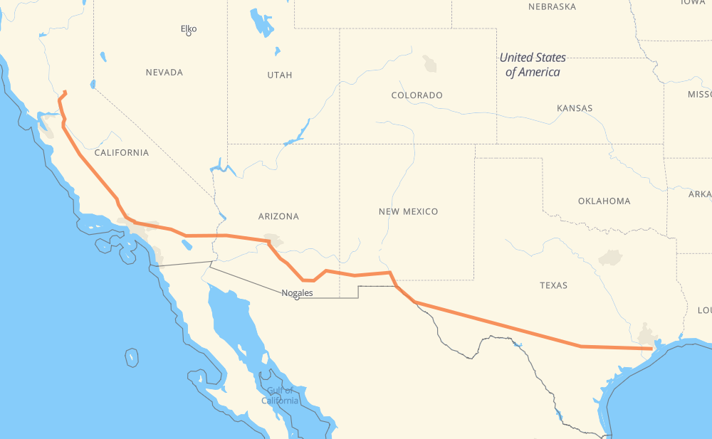
The distance from Lincoln to Santa Fe is 1,992 miles by road including 1,972 miles on motorways. Road takes approximately 30 hours and 42 minutes and goes through Sacramento, Stockton, Santa Clarita, Los Angeles, Glendale, La Cañada Flintridge and Pasadena.
You can adjust fuel consumption and fuel price here.
How long is a car ride from Lincoln to Santa Fe?
Driving time:
30 h 42 min
This time is calculated for driving at the maximum permitted speed, taking into account traffic rules restrictions.
1,320 mi with a maximum speed 68 mph = 19 h 24 min
263 mi with a maximum speed 65 mph = 4 h 3 min
202 mi with a maximum speed 62 mph = 3 h 15 min
36 mi with a maximum speed 60 mph = 36 min
8 mi with a maximum speed 56 mph = 8 min
12 mi with a maximum speed 55 mph = 12 min
149 mi with a maximum speed 50 mph = 3 h
The calculated driving time does not take into account intermediate stops and traffic jams.
How far is Lincoln to Santa Fe by land?
The distance between Lincoln and Santa Fe is 1,992.1 mi by road including 1,972.2 mi on motorways.
Precise satellite coordinates of highways were used for this calculation. The start and finish points are the centers of Lincoln and Santa Fe respectively.
How far is Lincoln to Santa Fe by plane?
The shortest distance (air line, as the crow flies) between Lincoln and Santa Fe is 1,628.6 mi.
This distance is calculated using the Haversine formula as a great-circle distance between two points on the surface of a sphere. The start and finish points are the centers of Lincoln and Santa Fe respectively. Actual distance between airports may be different.
How many hours is Lincoln from Santa Fe by plane?
Boeing 737 airliner needs 3 h 16 min to cover the distance of 1,629 mi at a cruising speed of 497 mph.
Small plane "Cessna 172" needs 11 h 54 min to flight this distance at average speed of 136 mph.
This time is approximate and do not take into account takeoff and landing times, airport location and other real world factors.
How long is a helicopter ride from Lincoln to Santa Fe?
Fast helicopter "Eurocopter AS350" or "Hughes OH-6 Cayuse" need 10 h 55 min to cover the distance of 1,629 mi at a cruising speed of 149 mph.
Popular "Robinson R44" needs 12 h 28 min to flight this distance at average speed of 130 mph.
This time is approximate and do not take into account takeoff and landing times, aerodrome location and other real world factors.
What city is halfway between Lincoln and Santa Fe?
The halfway point between Lincoln and Santa Fe is Olga. It is located about 12 mi from the exact midpoint by road.
The distance from Olga to Lincoln is 1,008 mi and driving will take about 15 h 20 min. The road between Olga and Santa Fe has length 984 mi and will take approximately 15 h 22 min.
The other cities located close to halfway point:
Willcox is in 979 mi from Lincoln and 1,013 mi from Santa Fe
Steins is in 1,030 mi from Lincoln and 962 mi from Santa Fe
Mondel is in 1,036 mi from Lincoln and 956 mi from Santa Fe
Where is Lincoln in relation to Santa Fe?
Lincoln is located 1,629 mi north-west of Santa Fe.
Lincoln has geographic coordinates: latitude 38.89157, longitude -121.29318.
Santa Fe has geographic coordinates: latitude 29.37801, longitude -95.10576.
Which highway goes from Lincoln to Santa Fe?
The route from Lincoln to Santa Fe follows I 10, I 5, US 70, US 180.