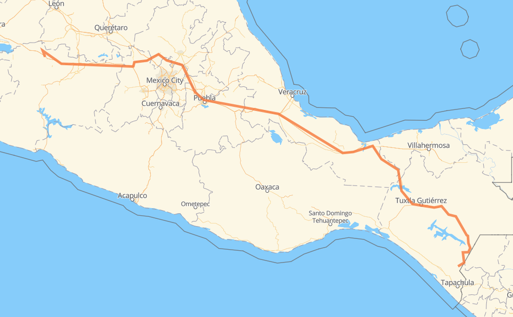
Distance between Los Fresnos and Motozintla de Mendoza
The distance from Los Fresnos to Motozintla de Mendoza is 953 miles by road including 610 miles on motorways. Road takes approximately 17 hours and 12 minutes and goes through Orizaba, Tuxtla Gutiérrez, Comitán de Dominguez, Panindicuaro, Huaniqueo de Morales, Maravatio and Pastores.
| Shortest distance by air | 715 mi ✈️ |
| Car route length | 952.6 mi 🚗 |
| Driving time | 17 h 12 min |
| Fuel amount | 32.4 gal |
| Fuel cost | 127.3 USD |
| Toll roads cost | 1,160 + ? MXN |
| Point | Distance | Time | Fuel | |
| Los Fresnos | 0 mi | 00 min | 0.0 gal | |
|
MEX 15D 43 mi, 53 min
|
||||
| Panindicuaro | 43 mi | 53 min | 1.3 gal | |
|
MEX 15D 19 mi, 19 min
|
||||
| Huaniqueo de Morales | 62 mi | 1 h 12 min | 2.0 gal | |
|
MEX 15D 70 mi, 1 h 08 min
|
||||
| Maravatio | 132 mi | 2 h 20 min | 4.4 gal | |
|
MEX 15D 72 mi, 1 h 16 min
|
||||
| Jilotepec de Molina Enriquez | 203 mi | 3 h 37 min | 6.8 gal | |
|
MEX M40D 218 mi, 3 h 51 min
|
||||
| Orizaba | 422 mi | 7 h 29 min | 14.3 gal | |
|
MEX 150D MEX 180D 349 mi, 5 h 59 min
|
||||
| Tuxtla Gutiérrez | 771 mi | 13 h 28 min | 26.2 gal | |
|
MEX 190D 82 mi, 1 h 38 min
|
||||
| Comitán de Dominguez | 853 mi | 15 h 07 min | 28.3 gal | |
|
MEX 190 101 mi, 2 h 04 min
|
||||
| Motozintla de Mendoza | 954 mi | 17 h 12 min | 32.3 gal | |
Frequently Asked Questions
How many toll booths are there from Los Fresnos to Motozintla de Mendoza?
There are 19 toll booths between Los Fresnos and Motozintla de Mendoza: Fortín, Cuitláhuac, Cosamaloapan, Acayucan, Antonio Dovali, Las Choapas, Zinapecuaro, Contepec, Panindicuaro, Atlacomulco — Maravatio, Atlacomulco 2, San Martin Texmelucan, San Martín, Viaducto Elevado de Puebla, Amozoc, Esperanza 27, Ocozocoautla 182, Malpasito and Chiapa de Corzo.
How much does the toll booths cost from Los Fresnos to Motozintla de Mendoza?
Toll roads cost: Panindicuaro (?) + Zinapecuaro (161 MXN) + Contepec (?) + Atlacomulco — Maravatio (50 MXN) + Atlacomulco 2 (?) + San Martin Texmelucan (?) + San Martín (42 MXN) + Viaducto Elevado de Puebla (?) + Amozoc (72 MXN) + Esperanza 27 (140 MXN) + Fortín (33 MXN) + Cuitláhuac (114 MXN) + Cosamaloapan (229 MXN) + Acayucan (?) + Antonio Dovali (20 MXN) + Las Choapas (82 MXN) + Malpasito (82 MXN) + Ocozocoautla 182 (82 MXN) + Chiapa de Corzo (53 MXN) = 1,160 + ? MXN
How much does it cost to drive from Los Fresnos to Motozintla de Mendoza?
Fuel cost: 127.3 USD
This fuel cost is calculated as: (Route length 952.6 mi) / (Fuel consumption 29.4 mpg) * (Fuel price 3.93 USD / gal)
You can adjust fuel consumption and fuel price here.
Toll roads cost: 1,160 + ? MXN
How long is a car ride from Los Fresnos to Motozintla de Mendoza?
Driving time: 17 h 12 min
This time is calculated for driving at the maximum permitted speed, taking into account traffic rules restrictions.
- 80 mi with a maximum speed 68 mph = 1 h 10 min
- 344 mi with a maximum speed 62 mph = 5 h 32 min
- 146 mi with a maximum speed 56 mph = 2 h 36 min
- 13 mi with a maximum speed 56 mph = 14 min
- 345 mi with a maximum speed 50 mph = 6 h 56 min
- 8 mi with a maximum speed 43 mph = 10 min
- 12 mi with a maximum speed 37 mph = 19 min
- 6 mi with a maximum speed 31 mph = 12 min
The calculated driving time does not take into account intermediate stops and traffic jams.
How far is Los Fresnos to Motozintla de Mendoza by land?
The distance between Los Fresnos and Motozintla de Mendoza is 952.6 mi by road including 610.2 mi on motorways.
Precise satellite coordinates of highways were used for this calculation. The start and finish points are the centers of Los Fresnos and Motozintla de Mendoza respectively.
How far is Los Fresnos to Motozintla de Mendoza by plane?
The shortest distance (air line, as the crow flies) between Los Fresnos and Motozintla de Mendoza is 715.2 mi.
This distance is calculated using the Haversine formula as a great-circle distance between two points on the surface of a sphere. The start and finish points are the centers of Los Fresnos and Motozintla de Mendoza respectively. Actual distance between airports may be different.
How many hours is Los Fresnos from Motozintla de Mendoza by plane?
Boeing 737 airliner needs 1 h 26 min to cover the distance of 715 mi at a cruising speed of 497 mph.
Small plane "Cessna 172" needs 5 h 13 min to flight this distance at average speed of 136 mph.
This time is approximate and do not take into account takeoff and landing times, airport location and other real world factors.
How long is a helicopter ride from Los Fresnos to Motozintla de Mendoza?
Fast helicopter "Eurocopter AS350" or "Hughes OH-6 Cayuse" need 4 h 47 min to cover the distance of 715 mi at a cruising speed of 149 mph.
Popular "Robinson R44" needs 5 h 28 min to flight this distance at average speed of 130 mph.
This time is approximate and do not take into account takeoff and landing times, aerodrome location and other real world factors.
What city is halfway between Los Fresnos and Motozintla de Mendoza?
The halfway point between Los Fresnos and Motozintla de Mendoza is Piedra Herrada. It is located about 6 mi from the exact midpoint by road.
The distance from Piedra Herrada to Los Fresnos is 470 mi and driving will take about 8 h 13 min. The road between Piedra Herrada and Motozintla de Mendoza has length 483 mi and will take approximately 8 h 58 min.
The other cities located close to halfway point:
Where is Los Fresnos in relation to Motozintla de Mendoza?
Los Fresnos is located 715 mi north-west of Motozintla de Mendoza.
Los Fresnos has geographic coordinates: latitude 20.04087, longitude -101.94289.
Motozintla de Mendoza has geographic coordinates: latitude 15.3652, longitude -92.24775.
Which highway goes from Los Fresnos to Motozintla de Mendoza?
The route from Los Fresnos to Motozintla de Mendoza follows MEX 15D, MEX 150D, MEX 180D, MEX 145D, MEX M40D, MEX 190.
Other minor sections pass along the road:
- MEX 211: 40 mi
- MEX 190D: 29 mi
- MEX 37: 7 mi
- MICH 27: 6 mi
- MEX 180: 4 mi
- MEX 040D: 4 mi