Distance between Madadeni and Hospital
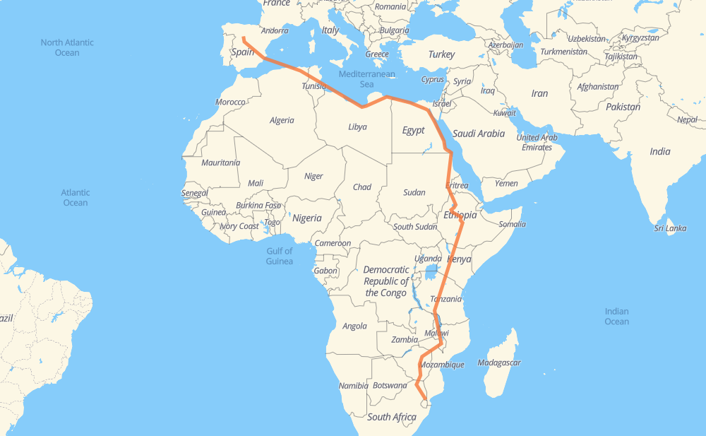
The distance from Madadeni to Hospital is 7,994 miles by road including 916 miles on motorways. Road takes approximately 166 hours and 26 minutes and goes through Louis Trichardt, Masvingo, Harare, Tete, Mzuzu, Iringa and Dodoma.
| Shortest distance by air | 5,215 mi ✈️ |
| Car route length | 7,993.9 mi 🚗 |
| Driving time | 166 h 26 min |
| Fuel amount | 271.9 gal |
| Fuel cost | 1,068.6 USD |
| Point | Distance | Time | Fuel | |
| Madadeni | 0 mi | 00 min | 0.0 gal | |
|
R40 312 mi, 6 h 07 min
|
||||
| Louis Trichardt | 312 mi | 6 h 07 min | 10.4 gal | |
|
R578 A4 249 mi, 4 h 29 min
|
||||
| Masvingo | 561 mi | 10 h 36 min | 19.0 gal | |
|
A4 183 mi, 3 h 16 min
|
||||
| Harare | 744 mi | 13 h 53 min | 25.2 gal | |
|
R5 A2 234 mi, 4 h 19 min
|
||||
| Tete | 978 mi | 18 h 12 min | 33.2 gal | |
|
N7 M5 449 mi, 8 h 40 min
|
||||
| Mzuzu | 1,427 mi | 26 h 53 min | 48.2 gal | |
|
M5 M1 411 mi, 8 h 24 min
|
||||
| Iringa | 1,839 mi | 35 h 18 min | 61.3 gal | |
|
T1 T5 199 mi, 4 h 23 min
|
||||
| Dodoma | 2,038 mi | 39 h 42 min | 68.7 gal | |
|
T5 459 mi, 9 h 00 min
|
||||
| Thika | 2,497 mi | 48 h 43 min | 84.7 gal | |
|
A2 306 mi, 5 h 55 min
|
||||
| Marsabit | 2,803 mi | 54 h 38 min | 95.1 gal | |
|
A2 6 352 mi, 7 h 13 min
|
||||
| Dilla | 3,155 mi | 61 h 52 min | 107.1 gal | |
|
6 66 mi, 1 h 19 min
|
||||
| Shashamane | 3,221 mi | 63 h 11 min | 109.5 gal | |
|
6 3 342 mi, 6 h 59 min
|
||||
| Debre Markos | 3,564 mi | 70 h 10 min | 120.9 gal | |
|
3 160 mi, 3 h 10 min
|
||||
| Bahir Dar | 3,723 mi | 73 h 21 min | 126.6 gal | |
|
3 107 mi, 2 h 02 min
|
||||
| Gonder | 3,831 mi | 75 h 23 min | 130.2 gal | |
|
3 S-2 273 mi, 5 h 06 min
|
||||
| Aroma | 4,104 mi | 80 h 29 min | 138.9 gal | |
|
250 mi, 4 h 33 min
|
||||
| Sinkāt | 4,354 mi | 85 h 02 min | 147.9 gal | |
|
37 mi, 42 min
|
||||
| Sawakin | 4,391 mi | 85 h 45 min | 149.0 gal | |
|
39 mi, 44 min
|
||||
| Port Sudan | 4,431 mi | 86 h 29 min | 150.5 gal | |
|
248 mi, 4 h 35 min
|
||||
| حلايب | 4,678 mi | 91 h 04 min | 156.8 gal | |
|
11 137 mi, 2 h 45 min
|
||||
| Al Shalaten | 4,816 mi | 93 h 50 min | 161.5 gal | |
|
11 135 mi, 2 h 42 min
|
||||
| Marsa Alam | 4,950 mi | 96 h 33 min | 168.1 gal | |
|
11 87 mi, 1 h 35 min
|
||||
| Al Qusair | 5,037 mi | 98 h 08 min | 171.3 gal | |
|
11 50 mi, 56 min
|
||||
| Safaga | 5,088 mi | 99 h 04 min | 172.8 gal | |
|
11 123 mi, 2 h 11 min
|
||||
| Zaafaranah | 5,211 mi | 101 h 16 min | 174.6 gal | |
|
11 176 175 mi, 2 h 49 min
|
||||
| Cairo | 5,385 mi | 104 h 05 min | 182.3 gal | |
|
176 516 70 mi, 1 h 06 min
|
||||
| Sadat City | 5,456 mi | 105 h 12 min | 184.5 gal | |
|
27 10 300 mi, 5 h 15 min
|
||||
| Al Sellum | 5,755 mi | 110 h 28 min | 193.5 gal | |
|
10 5 392 mi, 7 h 11 min
|
||||
| Ajdabiya | 6,148 mi | 117 h 39 min | 209.0 gal | |
|
1 437 mi, 8 h 22 min
|
||||
| Zliten | 6,584 mi | 126 h 02 min | 223.8 gal | |
|
1 21 mi, 23 min
|
||||
| Khoms | 6,605 mi | 126 h 25 min | 224.5 gal | |
|
1 96 mi, 1 h 47 min
|
||||
| Al Zawiyah | 6,700 mi | 128 h 12 min | 227.4 gal | |
|
1 20 mi, 22 min
|
||||
| Sabrata | 6,720 mi | 128 h 35 min | 228.4 gal | |
|
1 22 mi, 25 min
|
||||
| Zuwarah | 6,742 mi | 129 h 01 min | 229.0 gal | |
|
1 RN 15 ط و 345 mi, 6 h 38 min
|
||||
| Tebessa | 7,088 mi | 135 h 40 min | 240.8 gal | |
|
RN 16 RN 10 121 mi, 2 h 21 min
|
||||
| Constantine | 7,209 mi | 138 h 02 min | 245.0 gal | |
|
A1 61 mi, 55 min
|
||||
| El Eulma | 7,269 mi | 138 h 57 min | 247.1 gal | |
|
A1 16 mi, 14 min
|
||||
| Setif | 7,286 mi | 139 h 12 min | 247.7 gal | |
|
A1 40 mi, 35 min
|
||||
| Bordj Bou Arreridjj | 7,326 mi | 139 h 47 min | 249.0 gal | |
|
A1 A-31 743 mi, 26 h 38 min
|
||||
| Hospital | 8,069 mi | 166 h 26 min | 274.4 gal | |
Frequently Asked Questions
How much does it cost to drive from Madadeni to Hospital?
Fuel cost: 1,068.6 USD
This fuel cost is calculated as: (Route length 7,993.9 mi) / (Fuel consumption 29.4 mpg) * (Fuel price 3.93 USD / gal)
You can adjust fuel consumption and fuel price here.
How long is a car ride from Madadeni to Hospital?
Driving time: 166 h 26 min
This time is calculated for driving at the maximum permitted speed, taking into account traffic rules restrictions.
- 633 mi with a maximum speed 68 mph = 9 h 18 min
- 140 mi with a maximum speed 62 mph = 2 h 15 min
- 3,449 mi with a maximum speed 56 mph = 61 h 34 min
- 188 mi with a maximum speed 56 mph = 3 h 21 min
- 3,175 mi with a maximum speed 50 mph = 63 h 52 min
- 12 mi with a maximum speed 43 mph = 16 min
- 73 mi with a maximum speed 37 mph = 1 h 57 min
- 167 mi with a maximum speed 31 mph = 5 h 23 min
- 3 mi with a maximum speed 25 mph = 8 min
- 1 mi with a maximum speed 19 mph = 2 min
- 227 mi with a maximum speed 12 mph = 18 h 15 min
The calculated driving time does not take into account intermediate stops and traffic jams.
How far is Madadeni to Hospital by land?
The distance between Madadeni and Hospital is 7,993.9 mi by road including 915.9 mi on motorways.
Precise satellite coordinates of highways were used for this calculation. The start and finish points are the centers of Madadeni and Hospital respectively.
How far is Madadeni to Hospital by plane?
The shortest distance (air line, as the crow flies) between Madadeni and Hospital is 5,214.5 mi.
This distance is calculated using the Haversine formula as a great-circle distance between two points on the surface of a sphere. The start and finish points are the centers of Madadeni and Hospital respectively. Actual distance between airports may be different.
How many hours is Madadeni from Hospital by plane?
Boeing 737 airliner needs 10 h 29 min to cover the distance of 5,215 mi at a cruising speed of 497 mph.
Small plane "Cessna 172" needs 38 h 8 min to flight this distance at average speed of 136 mph.
This time is approximate and do not take into account takeoff and landing times, airport location and other real world factors.
How long is a helicopter ride from Madadeni to Hospital?
Fast helicopter "Eurocopter AS350" or "Hughes OH-6 Cayuse" need 34 h 58 min to cover the distance of 5,215 mi at a cruising speed of 149 mph.
Popular "Robinson R44" needs 39 h 57 min to flight this distance at average speed of 130 mph.
This time is approximate and do not take into account takeoff and landing times, aerodrome location and other real world factors.
What city is halfway between Madadeni and Hospital?
The halfway point between Madadeni and Hospital is Omhajer. It is located about 3 mi from the exact midpoint by road.
The distance from Omhajer to Madadeni is 3,994 mi and driving will take about 78 h 18 min. The road between Omhajer and Hospital has length 4,000 mi and will take approximately 88 h 7 min.
The other cities located close to halfway point:
Where is Madadeni in relation to Hospital?
Madadeni is located 5,215 mi south-east of Hospital.
Madadeni has geographic coordinates: latitude -25.8125, longitude 31.79139.
Hospital has geographic coordinates: latitude 41.65708, longitude -4.71692.
Which highway goes from Madadeni to Hospital?
The route from Madadeni to Hospital follows 11, 1, A2, 3, T5, 6, A4, M5, 10, A1, 5, M1, T1, A-31, RN 15 ط و, N7, RN 10, A-3, A104, RN 1 ط و, 261, R40, N1, 27, A-6, T10, T2.
Other minor sections pass along the road:
- 176: 62 mi
- S-2: 61 mi
- R578: 56 mi
- A 1 طس: 45 mi
- AP-6: 43 mi
- M6: 35 mi
- 4: 31 mi
- R538: 31 mi
- N4: 30 mi
- N8: 30 mi
- R529: 27 mi
- R526: 24 mi
- P43/3: 19 mi
- 516: 17 mi
- R71: 15 mi
- P-2: 15 mi
- A-62: 14 mi
- RN 11: 12 mi
- RN 3: 11 mi
- R570: 7 mi
- RN 16: 7 mi
- RN 5: 4 mi
- R523: 3 mi
- M-500: 3 mi
- R531: 1 mi
- RN 16 ط و: 1 mi
- R5: 1 mi
- RR 124 ط ج: 1 mi
- R2: 1 mi