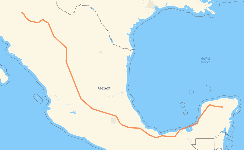
The distance from Madera to Santa María Tuz is 1,975 miles by road including 1,059 miles on motorways. Road takes approximately 34 hours and 22 minutes and goes through Cuauhtémoc, Delicias, Camargo, Jiménez, Fresnillo, Aguascalientes and Salamanca.
You can adjust fuel consumption and fuel price here.
Toll roads cost:
2,250 + ? MXN
How long is a car ride from Madera to Santa María Tuz?
Driving time:
34 h 22 min
This time is calculated for driving at the maximum permitted speed, taking into account traffic rules restrictions.
404 mi with a maximum speed 68 mph = 5 h 56 min
518 mi with a maximum speed 62 mph = 8 h 20 min
384 mi with a maximum speed 56 mph = 6 h 51 min
186 mi with a maximum speed 56 mph = 3 h 19 min
469 mi with a maximum speed 50 mph = 9 h 25 min
5 mi with a maximum speed 43 mph = 7 min
7 mi with a maximum speed 37 mph = 10 min
2 mi with a maximum speed 31 mph = 3 min
1 mi with a maximum speed 25 mph = 2 min
1 mi with a maximum speed 19 mph = 4 min
The calculated driving time does not take into account intermediate stops and traffic jams.
How far is Madera to Santa María Tuz by land?
The distance between Madera and Santa María Tuz is 1,975.3 mi by road including 1,059.4 mi on motorways.
Precise satellite coordinates of highways were used for this calculation. The start and finish points are the centers of Madera and Santa María Tuz respectively.
How far is Madera to Santa María Tuz by plane?
The shortest distance (air line, as the crow flies) between Madera and Santa María Tuz is 1,370.7 mi.
This distance is calculated using the Haversine formula as a great-circle distance between two points on the surface of a sphere. The start and finish points are the centers of Madera and Santa María Tuz respectively. Actual distance between airports may be different.
How many hours is Madera from Santa María Tuz by plane?
Boeing 737 airliner needs 2 h 45 min to cover the distance of 1,371 mi at a cruising speed of 497 mph.
Small plane "Cessna 172" needs 10 h 1 min to flight this distance at average speed of 136 mph.
This time is approximate and do not take into account takeoff and landing times, airport location and other real world factors.
How long is a helicopter ride from Madera to Santa María Tuz?
Fast helicopter "Eurocopter AS350" or "Hughes OH-6 Cayuse" need 9 h 11 min to cover the distance of 1,371 mi at a cruising speed of 149 mph.
Popular "Robinson R44" needs 10 h 30 min to flight this distance at average speed of 130 mph.
This time is approximate and do not take into account takeoff and landing times, aerodrome location and other real world factors.
What city is halfway between Madera and Santa María Tuz?
The halfway point between Madera and Santa María Tuz is Santa Bárbara de la Cueva. It is located about 16 mi from the exact midpoint by road.
The distance from Santa Bárbara de la Cueva to Madera is 972 mi and driving will take about 16 h 35 min. The road between Santa Bárbara de la Cueva and Santa María Tuz has length 1,004 mi and will take approximately 17 h 47 min.
The other cities located close to halfway point:
Xochitlán de las Flores is in 1,019 mi from Madera and 956 mi from Santa María Tuz
Tezoquipa is in 1,034 mi from Madera and 942 mi from Santa María Tuz
El Jaral is in 938 mi from Madera and 1,038 mi from Santa María Tuz
Where is Madera in relation to Santa María Tuz?
Madera is located 1,371 mi north-west of Santa María Tuz.
Madera has geographic coordinates: latitude 29.19554, longitude -108.14222.
Santa María Tuz has geographic coordinates: latitude 20.74388, longitude -88.30118.
Which highway goes from Madera to Santa María Tuz?
The route from Madera to Santa María Tuz follows MEX 180, MEX 45D, MEX 49D, MEX 49, MEX 150D, MEX 145D, MEX 180D, MEX 45, MEX M40D, MEX 16, CHIH 11.