Distance between Magdalena and La Huerta (Cuarto Poder)
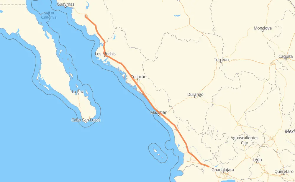
The distance from Magdalena to La Huerta (Cuarto Poder) is 646 miles by road including 616 miles on motorways. Road takes approximately 11 hours and 21 minutes and goes through Tepic, Dimas (Estación Dimas), Gabriel Leyva Solano, Los Mochis, Navojoa and Ciudad Obregon.
| Shortest distance by air | 593 mi ✈️ |
| Car route length | 645.6 mi 🚗 |
| Driving time | 11 h 21 min |
| Fuel amount | 22 gal |
| Fuel cost | 86.3 USD |
| Toll roads cost | 1,509 + ? MXN |
| Point | Distance | Time | Fuel | |
| Magdalena | 0 mi | 00 min | 0.0 gal | |
|
MEX 15D 86 mi, 1 h 22 min
|
||||
| Tepic | 86 mi | 1 h 22 min | 2.7 gal | |
|
MEX 15D 124 mi, 1 h 59 min
|
||||
| El Rosario | 209 mi | 3 h 22 min | 6.9 gal | |
|
MEX 15D 7 mi, 06 min
|
||||
| Otates | 216 mi | 3 h 28 min | 7.3 gal | |
|
MEX 15D 9 mi, 08 min
|
||||
| El Huajote | 224 mi | 3 h 37 min | 7.4 gal | |
|
MEX 15D 68 mi, 1 h 08 min
|
||||
| Dimas (Estación Dimas) | 293 mi | 4 h 45 min | 9.7 gal | |
|
MEX 15D 180 mi, 3 h 10 min
|
||||
| Gabriel Leyva Solano | 472 mi | 7 h 55 min | 15.8 gal | |
|
MEX 15D 27 mi, 31 min
|
||||
| Los Mochis | 500 mi | 8 h 26 min | 16.9 gal | |
|
MEX 15D 99 mi, 1 h 55 min
|
||||
| Navojoa | 598 mi | 10 h 21 min | 20.2 gal | |
|
MEX 15D 40 mi, 49 min
|
||||
| Ciudad Obregon | 638 mi | 11 h 11 min | 21.6 gal | |
|
MEX 15 7 mi, 09 min
|
||||
| 27.55383, -109.93383 | 646 mi | 11 h 21 min | 22.0 gal | |
Frequently Asked Questions
How many toll booths are there from Magdalena to La Huerta (Cuarto Poder)?
There are 15 toll booths between Magdalena and La Huerta (Cuarto Poder): Fundicion, Estacion Don La Jaula, San Miguel, Sinaloa, Las Brisas, San Pedro km 197+100, Costa Rica, Marmol, El Rosario, Acaponeta, Ruiz, Trapichillo, Santa Maria del Oro, Plan de Barrancas and El Pisal.
How much does the toll booths cost from Magdalena to La Huerta (Cuarto Poder)?
Toll roads cost: Plan de Barrancas (195 MXN) + Santa Maria del Oro (115 MXN) + Trapichillo (80 MXN) + Ruiz (?) + Acaponeta (240 MXN) + El Rosario (140 MXN) + Marmol (131 MXN) + Costa Rica (152 MXN) + San Pedro km 197+100 (34 MXN) + El Pisal (73 MXN) + Las Brisas (76 MXN) + Sinaloa (24 MXN) + San Miguel (69 MXN) + Estacion Don La Jaula (90 MXN) + Fundicion (90 MXN) = 1,509 + ? MXN
How much does it cost to drive from Magdalena to La Huerta (Cuarto Poder)?
Fuel cost: 86.3 USD
This fuel cost is calculated as: (Route length 645.6 mi) / (Fuel consumption 29.4 mpg) * (Fuel price 3.93 USD / gal)
You can adjust fuel consumption and fuel price here.
Toll roads cost: 1,509 + ? MXN
How long is a car ride from Magdalena to La Huerta (Cuarto Poder)?
Driving time: 11 h 21 min
This time is calculated for driving at the maximum permitted speed, taking into account traffic rules restrictions.
- 106 mi with a maximum speed 68 mph = 1 h 33 min
- 282 mi with a maximum speed 62 mph = 4 h 32 min
- 6 mi with a maximum speed 56 mph = 6 min
- 7 mi with a maximum speed 56 mph = 7 min
- 229 mi with a maximum speed 50 mph = 4 h 35 min
- 7 mi with a maximum speed 43 mph = 10 min
- 7 mi with a maximum speed 37 mph = 11 min
- 2 mi with a maximum speed 31 mph = 4 min
The calculated driving time does not take into account intermediate stops and traffic jams.
How far is Magdalena to La Huerta (Cuarto Poder) by land?
The distance between Magdalena and La Huerta (Cuarto Poder) is 645.6 mi by road including 615.8 mi on motorways.
Precise satellite coordinates of highways were used for this calculation. The start and finish points are the centers of Magdalena and La Huerta (Cuarto Poder) respectively.
How far is Magdalena to La Huerta (Cuarto Poder) by plane?
The shortest distance (air line, as the crow flies) between Magdalena and La Huerta (Cuarto Poder) is 592.8 mi.
This distance is calculated using the Haversine formula as a great-circle distance between two points on the surface of a sphere. The start and finish points are the centers of Magdalena and La Huerta (Cuarto Poder) respectively. Actual distance between airports may be different.
How many hours is Magdalena from La Huerta (Cuarto Poder) by plane?
Boeing 737 airliner needs 1 h 11 min to cover the distance of 593 mi at a cruising speed of 497 mph.
Small plane "Cessna 172" needs 4 h 20 min to flight this distance at average speed of 136 mph.
This time is approximate and do not take into account takeoff and landing times, airport location and other real world factors.
How long is a helicopter ride from Magdalena to La Huerta (Cuarto Poder)?
Fast helicopter "Eurocopter AS350" or "Hughes OH-6 Cayuse" need 3 h 58 min to cover the distance of 593 mi at a cruising speed of 149 mph.
Popular "Robinson R44" needs 4 h 32 min to flight this distance at average speed of 130 mph.
This time is approximate and do not take into account takeoff and landing times, aerodrome location and other real world factors.
What city is halfway between Magdalena and La Huerta (Cuarto Poder)?
The halfway point between Magdalena and La Huerta (Cuarto Poder) is Tanques. It is located about 3 mi from the exact midpoint by road.
The distance from Tanques to Magdalena is 320 mi and driving will take about 5 h 15 min. The road between Tanques and La Huerta (Cuarto Poder) has length 326 mi and will take approximately 6 h 5 min.
The other cities located close to halfway point:
Where is Magdalena in relation to La Huerta (Cuarto Poder)?
Magdalena is located 593 mi south-east of La Huerta (Cuarto Poder).
Magdalena has geographic coordinates: latitude 20.90881, longitude -103.9815.
La Huerta (Cuarto Poder) has geographic coordinates: latitude 27.55383, longitude -109.93383.
Which highway goes from Magdalena to La Huerta (Cuarto Poder)?
The route from Magdalena to La Huerta (Cuarto Poder) follows MEX 15D.
Other minor sections pass along the road:
- MEX 15: 11 mi