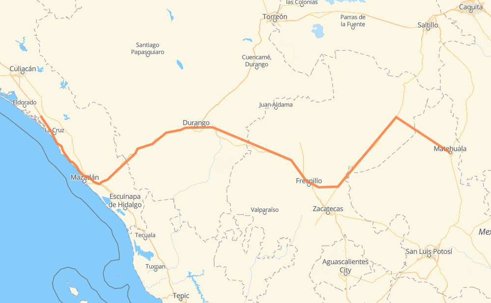
Distance between Matehuala and Ricardo Flores Magón
The distance from Matehuala to Ricardo Flores Magón is 569 miles by road including 155 miles on motorways. Road takes approximately 10 hours and 38 minutes and goes through Fresnillo, Dimas (Estación Dimas), San José de las Trojes, Cedral, Sombrerete, Vicente Guerrero and Nombre de Dios.
| Shortest distance by air | 410 mi ✈️ |
| Car route length | 568.6 mi 🚗 |
| Driving time | 10 h 38 min |
| Fuel amount | 19.3 gal |
| Fuel cost | 76 USD |
| Toll roads cost | 819 MXN |
| Point | Distance | Time | Fuel | |
| Matehuala | 0 mi | 00 min | 0.0 gal | |
|
3 mi, 05 min
|
||||
| San José de las Trojes | 3 mi | 05 min | 0.0 gal | |
|
MEX 62 Spur 9 mi, 14 min
|
||||
| Cedral | 13 mi | 20 min | 0.2 gal | |
|
MEX 62 MEX 54 182 mi, 3 h 25 min
|
||||
| Fresnillo | 195 mi | 3 h 45 min | 6.5 gal | |
|
MEX 45D MEX 45 59 mi, 1 h 03 min
|
||||
| Sombrerete | 254 mi | 4 h 49 min | 8.4 gal | |
|
MEX 45 28 mi, 30 min
|
||||
| Vicente Guerrero | 282 mi | 5 h 19 min | 9.5 gal | |
|
MEX 45 21 mi, 23 min
|
||||
| Nombre de Dios | 303 mi | 5 h 42 min | 10.3 gal | |
|
MEX 45 32 mi, 35 min
|
||||
| Fracc. del Pilar | 336 mi | 6 h 18 min | 11.2 gal | |
|
DGO 45 MEX 40D 196 mi, 3 h 37 min
|
||||
| Dimas (Estación Dimas) | 532 mi | 9 h 55 min | 17.8 gal | |
|
MEX 15D 37 mi, 42 min
|
||||
| Ricardo Flores Magón | 569 mi | 10 h 38 min | 19.2 gal | |
Frequently Asked Questions
How many toll booths are there from Matehuala to Ricardo Flores Magón?
There are 6 toll booths between Matehuala and Ricardo Flores Magón: Marmol, Mesillas, Durango 95, Llano Grande, Coscomate and Morfín Chávez.
How much does the toll booths cost from Matehuala to Ricardo Flores Magón?
Toll roads cost: Morfín Chávez (40 MXN) + Durango 95 (67 MXN) + Llano Grande (100 MXN) + Coscomate (315 MXN) + Mesillas (166 MXN) + Marmol (131 MXN) = 819 MXN
How much does it cost to drive from Matehuala to Ricardo Flores Magón?
Fuel cost: 76 USD
This fuel cost is calculated as: (Route length 568.6 mi) / (Fuel consumption 29.4 mpg) * (Fuel price 3.93 USD / gal)
You can adjust fuel consumption and fuel price here.
Toll roads cost: 819 MXN
How long is a car ride from Matehuala to Ricardo Flores Magón?
Driving time: 10 h 38 min
This time is calculated for driving at the maximum permitted speed, taking into account traffic rules restrictions.
- 25 mi with a maximum speed 68 mph = 22 min
- 53 mi with a maximum speed 62 mph = 51 min
- 153 mi with a maximum speed 56 mph = 2 h 43 min
- 167 mi with a maximum speed 56 mph = 2 h 59 min
- 144 mi with a maximum speed 50 mph = 2 h 54 min
- 2 mi with a maximum speed 43 mph = 3 min
- 19 mi with a maximum speed 37 mph = 29 min
- 2 mi with a maximum speed 31 mph = 5 min
- 1 mi with a maximum speed 6 mph = 6 min
The calculated driving time does not take into account intermediate stops and traffic jams.
How far is Matehuala to Ricardo Flores Magón by land?
The distance between Matehuala and Ricardo Flores Magón is 568.6 mi by road including 155.3 mi on motorways.
Precise satellite coordinates of highways were used for this calculation. The start and finish points are the centers of Matehuala and Ricardo Flores Magón respectively.
How far is Matehuala to Ricardo Flores Magón by plane?
The shortest distance (air line, as the crow flies) between Matehuala and Ricardo Flores Magón is 410.1 mi.
This distance is calculated using the Haversine formula as a great-circle distance between two points on the surface of a sphere. The start and finish points are the centers of Matehuala and Ricardo Flores Magón respectively. Actual distance between airports may be different.
How many hours is Matehuala from Ricardo Flores Magón by plane?
Boeing 737 airliner needs 49 min to cover the distance of 410 mi at a cruising speed of 497 mph.
Small plane "Cessna 172" needs 3 h to flight this distance at average speed of 136 mph.
This time is approximate and do not take into account takeoff and landing times, airport location and other real world factors.
How long is a helicopter ride from Matehuala to Ricardo Flores Magón?
Fast helicopter "Eurocopter AS350" or "Hughes OH-6 Cayuse" need 2 h 45 min to cover the distance of 410 mi at a cruising speed of 149 mph.
Popular "Robinson R44" needs 3 h 8 min to flight this distance at average speed of 130 mph.
This time is approximate and do not take into account takeoff and landing times, aerodrome location and other real world factors.
What city is halfway between Matehuala and Ricardo Flores Magón?
The halfway point between Matehuala and Ricardo Flores Magón is Vicente Guerrero. It is located about 2 mi from the exact midpoint by road.
The distance from Vicente Guerrero to Matehuala is 282 mi and driving will take about 5 h 19 min. The road between Vicente Guerrero and Ricardo Flores Magón has length 286 mi and will take approximately 5 h 19 min.
The other cities located close to halfway point:
Where is Matehuala in relation to Ricardo Flores Magón?
Matehuala is located 410 mi east of Ricardo Flores Magón.
Matehuala has geographic coordinates: latitude 23.64648, longitude -100.64354.
Ricardo Flores Magón has geographic coordinates: latitude 24.17939, longitude -107.1056.
Which highway goes from Matehuala to Ricardo Flores Magón?
The route from Matehuala to Ricardo Flores Magón follows MEX 40D, MEX 45, MEX 15D, MEX 54, MEX 62.
Other minor sections pass along the road:
- ZAC 44: 26 mi
- DGO 45: 17 mi
- MEX 45D: 7 mi
- ZAC 60: 2 mi
- MEX 62 Spur: 2 mi