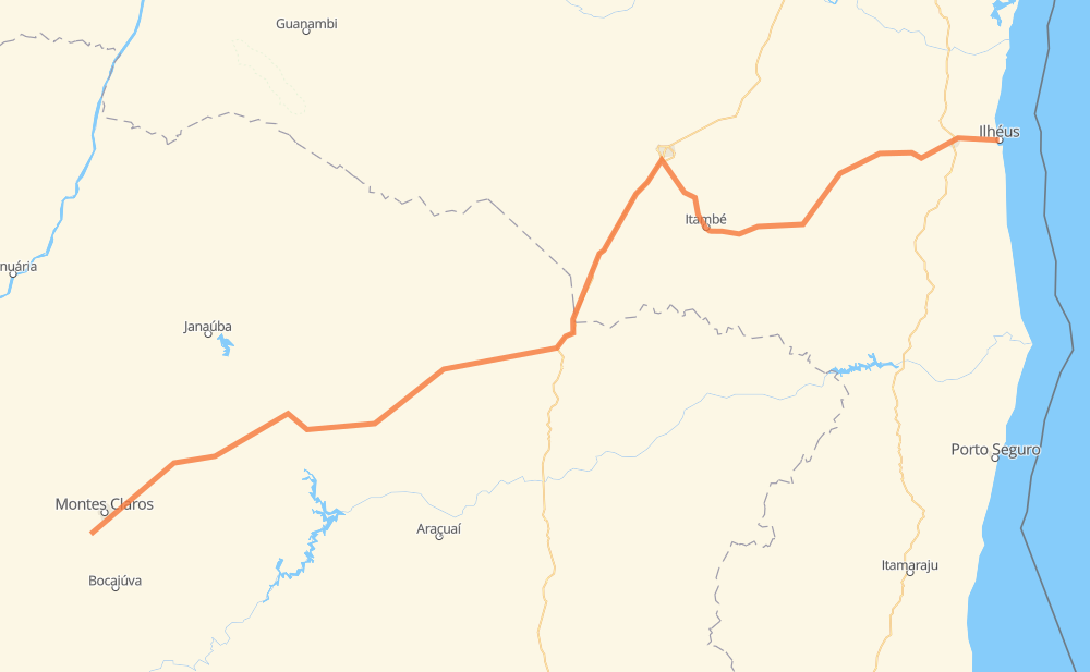
Distance between Mato Seco and Ilhéus
The distance from Mato Seco to Ilhéus is 467 miles by road. Road takes approximately 8 hours and 56 minutes and goes through Santo Amaro, Francisco Sá, Salinas, Felícia, Itambé and Quintas do Sul 1.
| Shortest distance by air | 355 mi ✈️ |
| Car route length | 467.3 mi 🚗 |
| Driving time | 8 h 56 min |
| Fuel amount | 15.9 gal |
| Fuel cost | 62.4 USD |
| Point | Distance | Time | Fuel | |
| Mato Seco | 0 mi | 00 min | 0.0 gal | |
|
BR-365 BR-251 9 mi, 10 min
|
||||
| Santo Amaro | 9 mi | 10 min | 0.3 gal | |
|
LMG-653 BR-251 42 mi, 47 min
|
||||
| Francisco Sá | 52 mi | 58 min | 1.2 gal | |
|
BR-251 46 mi, 54 min
|
||||
| Vale das Cancelas | 98 mi | 1 h 52 min | 2.7 gal | |
|
BR-251 39 mi, 45 min
|
||||
| Salinas | 137 mi | 2 h 38 min | 4.3 gal | |
|
BR-251 98 mi, 1 h 56 min
|
||||
| Divisa Alegre | 234 mi | 4 h 34 min | 7.9 gal | |
|
BR-116 56 mi, 1 h 01 min
|
||||
| Lagoa José Luiz | 290 mi | 5 h 36 min | 9.8 gal | |
|
BR-116 12 mi, 13 min
|
||||
| Felícia | 302 mi | 5 h 49 min | 10.2 gal | |
|
BR-116 BA-263 29 mi, 34 min
|
||||
| Itambé | 331 mi | 6 h 24 min | 10.8 gal | |
|
BA-263 30 mi, 34 min
|
||||
| Quintas do Sul 1 | 361 mi | 6 h 58 min | 12.3 gal | |
|
BR-415 106 mi, 1 h 57 min
|
||||
| -14.79305, -39.04602 | 467 mi | 8 h 55 min | 15.9 gal | |
Hotels of Ilhéus
Frequently Asked Questions
How much does it cost to drive from Mato Seco to Ilhéus?
Fuel cost: 62.4 USD
This fuel cost is calculated as: (Route length 467.3 mi) / (Fuel consumption 29.4 mpg) * (Fuel price 3.93 USD / gal)
You can adjust fuel consumption and fuel price here.
How long is a car ride from Mato Seco to Ilhéus?
Driving time: 8 h 56 min
This time is calculated for driving at the maximum permitted speed, taking into account traffic rules restrictions.
- 224 mi with a maximum speed 56 mph = 4 h
- 238 mi with a maximum speed 50 mph = 4 h 47 min
- 4 mi with a maximum speed 37 mph = 6 min
- 1 mi with a maximum speed 25 mph = 1 min
The calculated driving time does not take into account intermediate stops and traffic jams.
How far is Mato Seco to Ilhéus by land?
The distance between Mato Seco and Ilhéus is 467.3 mi by road.
Precise satellite coordinates of highways were used for this calculation. The start and finish points are the centers of Mato Seco and Ilhéus respectively.
How far is Mato Seco to Ilhéus by plane?
The shortest distance (air line, as the crow flies) between Mato Seco and Ilhéus is 354.8 mi.
This distance is calculated using the Haversine formula as a great-circle distance between two points on the surface of a sphere. The start and finish points are the centers of Mato Seco and Ilhéus respectively. Actual distance between airports may be different.
How many hours is Mato Seco from Ilhéus by plane?
Boeing 737 airliner needs 42 min to cover the distance of 355 mi at a cruising speed of 497 mph.
Small plane "Cessna 172" needs 2 h 35 min to flight this distance at average speed of 136 mph.
This time is approximate and do not take into account takeoff and landing times, airport location and other real world factors.
How long is a helicopter ride from Mato Seco to Ilhéus?
Fast helicopter "Eurocopter AS350" or "Hughes OH-6 Cayuse" need 2 h 22 min to cover the distance of 355 mi at a cruising speed of 149 mph.
Popular "Robinson R44" needs 2 h 43 min to flight this distance at average speed of 130 mph.
This time is approximate and do not take into account takeoff and landing times, aerodrome location and other real world factors.
What city is halfway between Mato Seco and Ilhéus?
The halfway point between Mato Seco and Ilhéus is Divisa Alegre. It is located about 1 mi from the exact midpoint by road.
The distance from Divisa Alegre to Mato Seco is 234 mi and driving will take about 4 h 34 min. The road between Divisa Alegre and Ilhéus has length 233 mi and will take approximately 4 h 21 min.
The other cities located close to halfway point:
Where is Mato Seco in relation to Ilhéus?
Mato Seco is located 355 mi south-west of Ilhéus.
Mato Seco has geographic coordinates: latitude -16.83631, longitude -43.94282.
Ilhéus has geographic coordinates: latitude -14.79305, longitude -39.04602.
Which highway goes from Mato Seco to Ilhéus?
The route from Mato Seco to Ilhéus follows BR-251, BR-116, BA-263, BR-415.
Other minor sections pass along the road:
- BA-262: 21 mi
- BR-122: 12 mi
- LMG-653: 10 mi
- BR-365: 7 mi
- MGC-251: 6 mi
- MGC-122: 6 mi
- CMG-122: 6 mi
- CMG-251: 6 mi
- CMG-135: 1 mi
- BR-135: 1 mi