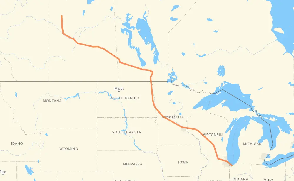
The distance from Meadow Lake to Portage is 1,568 miles by road including 854 miles on motorways. Road takes approximately 26 hours and 37 minutes and goes through North Battleford, Saskatoon, Yorkton, Portage la Prairie, Winnipeg, Grand Forks and Fargo.
You can adjust fuel consumption and fuel price here.
How long is a car ride from Meadow Lake to Portage?
Driving time:
26 h 37 min
This time is calculated for driving at the maximum permitted speed, taking into account traffic rules restrictions.
535 mi with a maximum speed 68 mph = 7 h 51 min
19 mi with a maximum speed 65 mph = 17 min
141 mi with a maximum speed 62 mph = 2 h 16 min
21 mi with a maximum speed 60 mph = 20 min
602 mi with a maximum speed 56 mph = 10 h 45 min
12 mi with a maximum speed 56 mph = 13 min
25 mi with a maximum speed 55 mph = 27 min
191 mi with a maximum speed 50 mph = 3 h 50 min
8 mi with a maximum speed 45 mph = 10 min
5 mi with a maximum speed 43 mph = 6 min
4 mi with a maximum speed 37 mph = 6 min
1 mi with a maximum speed 35 mph = 1 min
4 mi with a maximum speed 31 mph = 8 min
The calculated driving time does not take into account intermediate stops and traffic jams.
How far is Meadow Lake to Portage by land?
The distance between Meadow Lake and Portage is 1,568.3 mi by road including 853.8 mi on motorways.
Precise satellite coordinates of highways were used for this calculation. The start and finish points are the centers of Meadow Lake and Portage respectively.
How far is Meadow Lake to Portage by plane?
The shortest distance (air line, as the crow flies) between Meadow Lake and Portage is 1,304.3 mi.
This distance is calculated using the Haversine formula as a great-circle distance between two points on the surface of a sphere. The start and finish points are the centers of Meadow Lake and Portage respectively. Actual distance between airports may be different.
How many hours is Meadow Lake from Portage by plane?
Boeing 737 airliner needs 2 h 37 min to cover the distance of 1,304 mi at a cruising speed of 497 mph.
Small plane "Cessna 172" needs 9 h 32 min to flight this distance at average speed of 136 mph.
This time is approximate and do not take into account takeoff and landing times, airport location and other real world factors.
How long is a helicopter ride from Meadow Lake to Portage?
Fast helicopter "Eurocopter AS350" or "Hughes OH-6 Cayuse" need 8 h 44 min to cover the distance of 1,304 mi at a cruising speed of 149 mph.
Popular "Robinson R44" needs 9 h 59 min to flight this distance at average speed of 130 mph.
This time is approximate and do not take into account takeoff and landing times, aerodrome location and other real world factors.
What city is halfway between Meadow Lake and Portage?
The halfway point between Meadow Lake and Portage is Manvel. It is located about 16 mi from the exact midpoint by road.
The distance from Manvel to Meadow Lake is 800 mi and driving will take about 14 h 38 min. The road between Manvel and Portage has length 768 mi and will take approximately 11 h 58 min.
The other cities located close to halfway point:
Drayton is in 767 mi from Meadow Lake and 802 mi from Portage
Pittsburgh is in 759 mi from Meadow Lake and 810 mi from Portage
Grand Forks is in 811 mi from Meadow Lake and 757 mi from Portage
Where is Meadow Lake in relation to Portage?
Meadow Lake is located 1,304 mi north-west of Portage.
Meadow Lake has geographic coordinates: latitude 54.13026, longitude -108.43506.
Portage has geographic coordinates: latitude 41.57587, longitude -87.17615.
Which highway goes from Meadow Lake to Portage?
The route from Meadow Lake to Portage follows I 94, 16, I 90, PTH 16, I 29, US 81, 4, I 39.