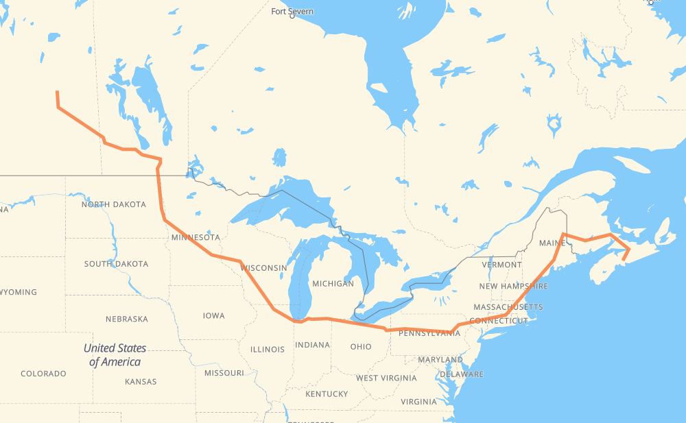
Distance between Melfort SK and Upper Sackville NS
The distance from Melfort to Upper Sackville is 2,991 miles by road including 2,475 miles on motorways. Road takes approximately 47 hours and 44 minutes and goes through Yorkton, Portage la Prairie, Winnipeg, Grand Forks, Fargo, Eau Claire and Madison.
| Shortest distance by air | 1,911 mi ✈️ |
| Car route length | 2,991.3 mi 🚗 |
| Driving time | 47 h 44 min |
| Fuel amount | 101.7 gal |
| Fuel cost | 396.8 USD |
| Point | Distance | Time | Fuel | |
| Melfort | 0 mi | 00 min | 0.0 gal | |
|
6 16 173 mi, 3 h 09 min
|
||||
| Yorkton | 173 mi | 3 h 09 min | 5.8 gal | |
|
16 PTH 16 229 mi, 4 h 14 min
|
||||
| Portage la Prairie | 403 mi | 7 h 23 min | 13.5 gal | |
|
PTH 1 53 mi, 58 min
|
||||
| Winnipeg | 456 mi | 8 h 21 min | 15.2 gal | |
|
PTH 100 I 29 142 mi, 2 h 34 min
|
||||
| Grand Forks | 598 mi | 10 h 56 min | 20.2 gal | |
|
I 29 74 mi, 1 h 17 min
|
||||
| Fargo | 672 mi | 12 h 14 min | 22.6 gal | |
|
I 29 I 94 327 mi, 5 h 03 min
|
||||
| Eau Claire | 999 mi | 17 h 17 min | 33.7 gal | |
|
I 94 175 mi, 2 h 35 min
|
||||
| Madison | 1,174 mi | 19 h 52 min | 39.7 gal | |
|
I 39 35 mi, 30 min
|
||||
| Janesville | 1,209 mi | 20 h 23 min | 41.0 gal | |
|
I 39 I 90 107 mi, 1 h 39 min
|
||||
| Chicago | 1,316 mi | 22 h 03 min | 44.3 gal | |
|
I 90 86 mi, 1 h 23 min
|
||||
| South Bend | 1,403 mi | 23 h 26 min | 47.6 gal | |
|
I 80 229 mi, 3 h 22 min
|
||||
| Elyria | 1,632 mi | 26 h 48 min | 55.4 gal | |
|
I 80 384 mi, 5 h 44 min
|
||||
| Scranton | 2,016 mi | 32 h 32 min | 68.5 gal | |
|
I 81 I 84 163 mi, 2 h 34 min
|
||||
| Waterbury | 2,179 mi | 35 h 07 min | 74.0 gal | |
|
I 84 27 mi, 27 min
|
||||
| Hartford | 2,205 mi | 35 h 34 min | 74.9 gal | |
|
I 84 64 mi, 1 h 03 min
|
||||
| Worcester | 2,269 mi | 36 h 38 min | 77.1 gal | |
|
I 290 I 495 40 mi, 38 min
|
||||
| Lowell | 2,310 mi | 37 h 16 min | 78.5 gal | |
|
I 495 I 95 96 mi, 1 h 30 min
|
||||
| Portland | 2,406 mi | 38 h 46 min | 81.8 gal | |
|
I 295 55 mi, 52 min
|
||||
| Augusta | 2,461 mi | 39 h 39 min | 83.6 gal | |
|
I 95 13 mi, 11 min
|
||||
| Waterville | 2,473 mi | 39 h 51 min | 83.8 gal | |
|
I 95 63 mi, 55 min
|
||||
| Bangor | 2,536 mi | 40 h 47 min | 86.0 gal | |
|
I 95 189 mi, 2 h 57 min
|
||||
| Fredericton | 2,725 mi | 43 h 44 min | 92.6 gal | |
|
2 106 mi, 1 h 33 min
|
||||
| Moncton | 2,830 mi | 45 h 17 min | 96.1 gal | |
|
2 NS 104 161 mi, 2 h 27 min
|
||||
| Upper Sackville | 2,991 mi | 47 h 44 min | 101.7 gal | |
Frequently Asked Questions
How much does it cost to drive from Melfort to Upper Sackville?
Fuel cost: 396.8 USD
This fuel cost is calculated as: (Route length 2,991.3 mi) / (Fuel consumption 29.4 mpg) * (Fuel price 3.9 USD / gal)
You can adjust fuel consumption and fuel price here.
How long is a car ride from Melfort to Upper Sackville?
Driving time: 47 h 44 min
This time is calculated for driving at the maximum permitted speed, taking into account traffic rules restrictions.
- 1,672 mi with a maximum speed 68 mph = 24 h 35 min
- 324 mi with a maximum speed 65 mph = 4 h 58 min
- 198 mi with a maximum speed 62 mph = 3 h 11 min
- 27 mi with a maximum speed 60 mph = 26 min
- 434 mi with a maximum speed 56 mph = 7 h 45 min
- 1 mi with a maximum speed 56 mph = 1 min
- 76 mi with a maximum speed 55 mph = 1 h 23 min
- 11 mi with a maximum speed 50 mph = 13 min
- 222 mi with a maximum speed 50 mph = 4 h 28 min
- 9 mi with a maximum speed 45 mph = 12 min
- 4 mi with a maximum speed 43 mph = 5 min
- 1 mi with a maximum speed 40 mph = 1 min
- 4 mi with a maximum speed 37 mph = 7 min
- 1 mi with a maximum speed 35 mph = 2 min
- 4 mi with a maximum speed 31 mph = 6 min
- 1 mi with a maximum speed 25 mph = 2 min
The calculated driving time does not take into account intermediate stops and traffic jams.
How far is Melfort to Upper Sackville by land?
The distance between Melfort and Upper Sackville is 2,991.3 mi by road including 2,474.9 mi on motorways.
Precise satellite coordinates of highways were used for this calculation. The start and finish points are the centers of Melfort and Upper Sackville respectively.
How far is Melfort to Upper Sackville by plane?
The shortest distance (air line, as the crow flies) between Melfort and Upper Sackville is 1,911.3 mi.
This distance is calculated using the Haversine formula as a great-circle distance between two points on the surface of a sphere. The start and finish points are the centers of Melfort and Upper Sackville respectively. Actual distance between airports may be different.
How many hours is Melfort from Upper Sackville by plane?
Boeing 737 airliner needs 3 h 50 min to cover the distance of 1,911 mi at a cruising speed of 497 mph.
Small plane "Cessna 172" needs 13 h 58 min to flight this distance at average speed of 136 mph.
This time is approximate and do not take into account takeoff and landing times, airport location and other real world factors.
How long is a helicopter ride from Melfort to Upper Sackville?
Fast helicopter "Eurocopter AS350" or "Hughes OH-6 Cayuse" need 12 h 49 min to cover the distance of 1,911 mi at a cruising speed of 149 mph.
Popular "Robinson R44" needs 14 h 38 min to flight this distance at average speed of 130 mph.
This time is approximate and do not take into account takeoff and landing times, aerodrome location and other real world factors.
What city is halfway between Melfort and Upper Sackville?
The halfway point between Melfort and Upper Sackville is Jamestown. It is located about 24 mi from the exact midpoint by road.
The distance from Jamestown to Melfort is 1,472 mi and driving will take about 24 h 26 min. The road between Jamestown and Upper Sackville has length 1,519 mi and will take approximately 23 h 18 min.
The other cities located close to halfway point:
Where is Melfort in relation to Upper Sackville?
Melfort is located 1,911 mi west of Upper Sackville.
Melfort has geographic coordinates: latitude 52.86499, longitude -104.61044.
Upper Sackville has geographic coordinates: latitude 44.80831, longitude -63.75557.
Which highway goes from Melfort to Upper Sackville?
The route from Melfort to Upper Sackville follows I 80, I 90, I 94, I 95, I 84, 2, PTH 16, I 29, 16, US 81, I 39, TCH, NS 104.
Other minor sections pass along the road:
- PTH 75: 58 mi
- I 495: 55 mi
- 6: 53 mi
- PTH 1: 53 mi
- I 295: 53 mi
- NS 102: 52 mi
- I 81: 35 mi
- 5: 34 mi
- I 694: 29 mi
- US 6: 24 mi
- PTH 83: 23 mi
- I 290: 20 mi
- US 51: 20 mi
- US 220: 17 mi
- 35: 15 mi
- PTH 100: 14 mi
- US 59: 11 mi
- 95: 9 mi
- NY 52: 7 mi
- 7: 7 mi
- 776: 6 mi
- PA 309: 5 mi
- US 10: 4 mi
- SR 11: 4 mi
- MN 95: 4 mi
- NS 101: 4 mi
- PTH 10: 4 mi
- PA 66: 4 mi
- US 1: 4 mi
- US 12: 4 mi
- US 7: 4 mi
- I 380: 4 mi
- MN 210: 3 mi
- US 202: 3 mi
- US 52: 3 mi
- 105: 3 mi
- US 220 Alternate: 2 mi
- ME 15: 2 mi
- WI 35: 2 mi
- PA 28 Truck: 2 mi
- NS 1: 2 mi
- PR 264: 2 mi
- 9: 2 mi
- 3: 2 mi
- WI 11: 2 mi
- Route 42: 1 mi
- 10: 1 mi
- PR 250: 1 mi
- 756: 1 mi
- PTH 5: 1 mi