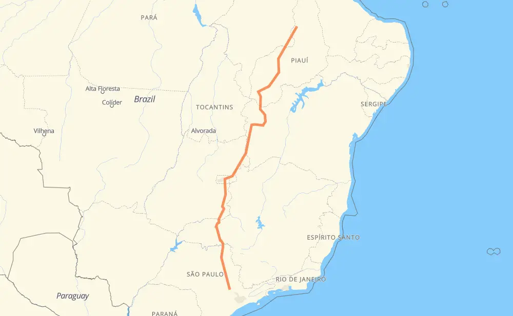
Distance between Monte Mor and Demerval Lobão
The distance from Monte Mor to Demerval Lobão is 1,583 miles by road including 344 miles on motorways. Road takes approximately 27 hours and 54 minutes and goes through Araras, Leme, São Sebastião, Chácaras Beira-rio, Pirassununga, Cravinhos and Jardim Manoel Penna.
| Shortest distance by air | 1,254 mi ✈️ |
| Car route length | 1,582.6 mi 🚗 |
| Driving time | 27 h 54 min |
| Fuel amount | 53.8 gal |
| Fuel cost | 211.6 USD |
| Point | Distance | Time | Fuel | |
| -22.94504, -47.31218 | 0 mi | 00 min | 0.0 gal | |
|
SP-348 22 mi, 22 min
|
||||
| Chácaras Beira-rio | 22 mi | 22 min | 1.4 gal | |
|
SP-348 30 mi, 27 min
|
||||
| Araras | 52 mi | 49 min | 2.3 gal | |
|
SP-330 12 mi, 11 min
|
||||
| Leme | 65 mi | 1 h 00 min | 2.7 gal | |
|
SP-330 12 mi, 10 min
|
||||
| Pirassununga | 76 mi | 1 h 11 min | 3.2 gal | |
|
SP-330 52 mi, 47 min
|
||||
| Cravinhos | 129 mi | 1 h 59 min | 4.9 gal | |
|
SP-330 8 mi, 07 min
|
||||
| Jardim Manoel Penna | 137 mi | 2 h 06 min | 5.3 gal | |
|
SP-330 9 mi, 08 min
|
||||
| Condomínio Balneário Recreativa | 145 mi | 2 h 15 min | 5.6 gal | |
|
SP-330 27 mi, 24 min
|
||||
| Orlândia | 172 mi | 2 h 39 min | 6.4 gal | |
|
SP-330 11 mi, 10 min
|
||||
| São Joaquim da Barra | 183 mi | 2 h 50 min | 6.8 gal | |
|
SP-330 BR-050 362 mi, 6 h 06 min
|
||||
| São Sebastião | 546 mi | 8 h 56 min | 19.1 gal | |
|
DF-130 BR-135 1,038 mi, 18 h 57 min
|
||||
| -5.36406, -42.67399 | 1,583 mi | 27 h 54 min | 54.5 gal | |
Frequently Asked Questions
How much does it cost to drive from Monte Mor to Demerval Lobão?
Fuel cost: 211.6 USD
This fuel cost is calculated as: (Route length 1,582.6 mi) / (Fuel consumption 29.4 mpg) * (Fuel price 3.93 USD / gal)
You can adjust fuel consumption and fuel price here.
How long is a car ride from Monte Mor to Demerval Lobão?
Driving time: 27 h 54 min
This time is calculated for driving at the maximum permitted speed, taking into account traffic rules restrictions.
- 273 mi with a maximum speed 68 mph = 4 h
- 52 mi with a maximum speed 62 mph = 50 min
- 1,041 mi with a maximum speed 56 mph = 18 h 35 min
- 11 mi with a maximum speed 56 mph = 11 min
- 199 mi with a maximum speed 50 mph = 4 h
- 1 mi with a maximum speed 37 mph = 1 min
- 1 mi with a maximum speed 31 mph = 2 min
- 5 mi with a maximum speed 25 mph = 11 min
The calculated driving time does not take into account intermediate stops and traffic jams.
How far is Monte Mor to Demerval Lobão by land?
The distance between Monte Mor and Demerval Lobão is 1,582.6 mi by road including 343.6 mi on motorways.
Precise satellite coordinates of highways were used for this calculation. The start and finish points are the centers of Monte Mor and Demerval Lobão respectively.
How far is Monte Mor to Demerval Lobão by plane?
The shortest distance (air line, as the crow flies) between Monte Mor and Demerval Lobão is 1,253.9 mi.
This distance is calculated using the Haversine formula as a great-circle distance between two points on the surface of a sphere. The start and finish points are the centers of Monte Mor and Demerval Lobão respectively. Actual distance between airports may be different.
How many hours is Monte Mor from Demerval Lobão by plane?
Boeing 737 airliner needs 2 h 31 min to cover the distance of 1,254 mi at a cruising speed of 497 mph.
Small plane "Cessna 172" needs 9 h 10 min to flight this distance at average speed of 136 mph.
This time is approximate and do not take into account takeoff and landing times, airport location and other real world factors.
How long is a helicopter ride from Monte Mor to Demerval Lobão?
Fast helicopter "Eurocopter AS350" or "Hughes OH-6 Cayuse" need 8 h 24 min to cover the distance of 1,254 mi at a cruising speed of 149 mph.
Popular "Robinson R44" needs 9 h 36 min to flight this distance at average speed of 130 mph.
This time is approximate and do not take into account takeoff and landing times, aerodrome location and other real world factors.
What city is halfway between Monte Mor and Demerval Lobão?
The halfway point between Monte Mor and Demerval Lobão is Vila Rosário. It is located about 35 mi from the exact midpoint by road.
The distance from Vila Rosário to Monte Mor is 757 mi and driving will take about 12 h 51 min. The road between Vila Rosário and Demerval Lobão has length 826 mi and will take approximately 15 h 2 min.
The other cities located close to halfway point:
Where is Monte Mor in relation to Demerval Lobão?
Monte Mor is located 1,254 mi south of Demerval Lobão.
Monte Mor has geographic coordinates: latitude -22.94504, longitude -47.31218.
Demerval Lobão has geographic coordinates: latitude -5.36406, longitude -42.67399.
Which highway goes from Monte Mor to Demerval Lobão?
The route from Monte Mor to Demerval Lobão follows BR-050, BR-135, BR-020, BR-343, SP-330, PI-250.
Other minor sections pass along the road:
- BR-242: 52 mi
- GO-436: 49 mi
- SP-348: 35 mi
- BR-316: 31 mi
- DF-130: 21 mi
- BR-479: 19 mi
- DF-250: 19 mi
- DF-100: 10 mi
- GO-108: 9 mi
- MG-223: 9 mi
- BR-230: 5 mi
- PI-394: 4 mi
- BR-262: 3 mi
- BR-251: 2 mi
- BR-040: 2 mi
- PI-140: 1 mi
- BR-267: 1 mi