Distance between Motozintla de Mendoza and Diez de Abril
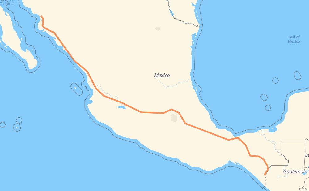
The distance from Motozintla de Mendoza to Diez de Abril is 1,636 miles by road including 1,309 miles on motorways. Road takes approximately 29 hours and goes through Comitán de Dominguez, Tuxtla Gutiérrez, Orizaba, Tonalá, Tepic, Dimas (Estación Dimas) and Gabriel Leyva Solano.
You can adjust fuel consumption and fuel price here.
Toll roads cost:
3,038 + ? MXN
How long is a car ride from Motozintla de Mendoza to Diez de Abril?
Driving time:
29 h
This time is calculated for driving at the maximum permitted speed, taking into account traffic rules restrictions.
203 mi with a maximum speed 68 mph = 2 h 58 min
651 mi with a maximum speed 62 mph = 10 h 28 min
144 mi with a maximum speed 56 mph = 2 h 34 min
14 mi with a maximum speed 56 mph = 14 min
595 mi with a maximum speed 50 mph = 11 h 57 min
15 mi with a maximum speed 43 mph = 20 min
15 mi with a maximum speed 37 mph = 23 min
1 mi with a maximum speed 31 mph = 1 min
1 mi with a maximum speed 25 mph = 1 min
The calculated driving time does not take into account intermediate stops and traffic jams.
How far is Motozintla de Mendoza to Diez de Abril by land?
The distance between Motozintla de Mendoza and Diez de Abril is 1,636.1 mi by road including 1,308.6 mi on motorways.
Precise satellite coordinates of highways were used for this calculation. The start and finish points are the centers of Motozintla de Mendoza and Diez de Abril respectively.
How far is Motozintla de Mendoza to Diez de Abril by plane?
The shortest distance (air line, as the crow flies) between Motozintla de Mendoza and Diez de Abril is 1,336.6 mi.
This distance is calculated using the Haversine formula as a great-circle distance between two points on the surface of a sphere. The start and finish points are the centers of Motozintla de Mendoza and Diez de Abril respectively. Actual distance between airports may be different.
How many hours is Motozintla de Mendoza from Diez de Abril by plane?
Boeing 737 airliner needs 2 h 41 min to cover the distance of 1,337 mi at a cruising speed of 497 mph.
Small plane "Cessna 172" needs 9 h 46 min to flight this distance at average speed of 136 mph.
This time is approximate and do not take into account takeoff and landing times, airport location and other real world factors.
How long is a helicopter ride from Motozintla de Mendoza to Diez de Abril?
Fast helicopter "Eurocopter AS350" or "Hughes OH-6 Cayuse" need 8 h 57 min to cover the distance of 1,337 mi at a cruising speed of 149 mph.
Popular "Robinson R44" needs 10 h 14 min to flight this distance at average speed of 130 mph.
This time is approximate and do not take into account takeoff and landing times, aerodrome location and other real world factors.
What city is halfway between Motozintla de Mendoza and Diez de Abril?
The halfway point between Motozintla de Mendoza and Diez de Abril is Pomoca. It is located about 3 mi from the exact midpoint by road.
The distance from Pomoca to Motozintla de Mendoza is 815 mi and driving will take about 14 h 42 min. The road between Pomoca and Diez de Abril has length 821 mi and will take approximately 14 h 17 min.
The other cities located close to halfway point:
Manto Del Rio is in 793 mi from Motozintla de Mendoza and 843 mi from Diez de Abril
Hondiga is in 780 mi from Motozintla de Mendoza and 856 mi from Diez de Abril
San Juanico Sector Dos is in 774 mi from Motozintla de Mendoza and 863 mi from Diez de Abril
Where is Motozintla de Mendoza in relation to Diez de Abril?
Motozintla de Mendoza is located 1,337 mi south-east of Diez de Abril.
Motozintla de Mendoza has geographic coordinates: latitude 15.3652, longitude -92.24775.
Diez de Abril has geographic coordinates: latitude 26.57925, longitude -109.16346.
Which highway goes from Motozintla de Mendoza to Diez de Abril?
The route from Motozintla de Mendoza to Diez de Abril follows MEX 15D, MEX 150D, MEX 180D, MEX 145D, MEX M40D, MEX 190.