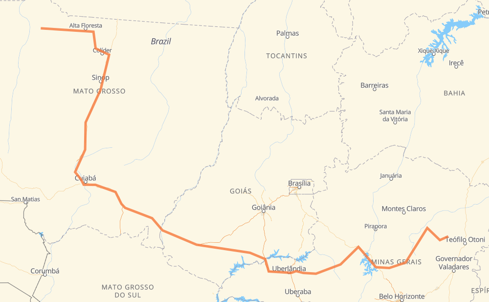
Distance between Nova Bandeirantes and Setubinha
The distance from Nova Bandeirantes to Setubinha is 1,877 miles by road including 146 miles on motorways. Road takes approximately 34 hours and 45 minutes and goes through Sorriso, Mário Raiter, Novo Mundo, Jaciara, Vila Goulart, Centralina and Monte Alegre de Minas.
| Shortest distance by air | 1,179 mi ✈️ |
| Car route length | 1,877.2 mi 🚗 |
| Driving time | 34 h 45 min |
| Fuel amount | 63.9 gal |
| Fuel cost | 251 USD |
| Point | Distance | Time | Fuel | |
| -9.84977, -57.81387 | 0 mi | 00 min | 0.0 gal | |
|
MT-208 375 mi, 6 h 58 min
|
||||
| Sorriso | 375 mi | 6 h 58 min | 25.3 gal | |
|
BR-163 248 mi, 4 h 36 min
|
||||
| Novo Mundo | 623 mi | 11 h 34 min | 33.7 gal | |
|
BR-163 99 mi, 1 h 46 min
|
||||
| Jaciara | 721 mi | 13 h 21 min | 37.1 gal | |
|
BR-163 47 mi, 53 min
|
||||
| Vila Goulart | 769 mi | 14 h 14 min | 38.8 gal | |
|
BR-364 439 mi, 7 h 58 min
|
||||
| Centralina | 1,208 mi | 22 h 13 min | 53.5 gal | |
|
BR-153 38 mi, 34 min
|
||||
| Monte Alegre de Minas | 1,246 mi | 22 h 47 min | 54.5 gal | |
|
BR-365 33 mi, 29 min
|
||||
| Tocantins | 1,279 mi | 23 h 16 min | 56.1 gal | |
|
BR-365 2 mi, 02 min
|
||||
| Dona Zulmira | 1,281 mi | 23 h 18 min | 56.2 gal | |
|
BR-365 137 mi, 2 h 29 min
|
||||
| Distrito Industrial I | 1,418 mi | 25 h 47 min | 60.9 gal | |
|
BR-365 MGC-367 460 mi, 8 h 57 min
|
||||
| Setubinha | 1,877 mi | 34 h 45 min | 76.4 gal | |
Frequently Asked Questions
How much does it cost to drive from Nova Bandeirantes to Setubinha?
Fuel cost: 251 USD
This fuel cost is calculated as: (Route length 1,877.2 mi) / (Fuel consumption 29.4 mpg) * (Fuel price 3.93 USD / gal)
You can adjust fuel consumption and fuel price here.
How long is a car ride from Nova Bandeirantes to Setubinha?
Driving time: 34 h 45 min
This time is calculated for driving at the maximum permitted speed, taking into account traffic rules restrictions.
- 112 mi with a maximum speed 68 mph = 1 h 38 min
- 29 mi with a maximum speed 62 mph = 27 min
- 1,137 mi with a maximum speed 56 mph = 20 h 18 min
- 20 mi with a maximum speed 56 mph = 21 min
- 552 mi with a maximum speed 50 mph = 11 h 7 min
- 11 mi with a maximum speed 37 mph = 17 min
- 9 mi with a maximum speed 31 mph = 17 min
- 7 mi with a maximum speed 25 mph = 16 min
The calculated driving time does not take into account intermediate stops and traffic jams.
How far is Nova Bandeirantes to Setubinha by land?
The distance between Nova Bandeirantes and Setubinha is 1,877.2 mi by road including 146 mi on motorways.
Precise satellite coordinates of highways were used for this calculation. The start and finish points are the centers of Nova Bandeirantes and Setubinha respectively.
How far is Nova Bandeirantes to Setubinha by plane?
The shortest distance (air line, as the crow flies) between Nova Bandeirantes and Setubinha is 1,178.7 mi.
This distance is calculated using the Haversine formula as a great-circle distance between two points on the surface of a sphere. The start and finish points are the centers of Nova Bandeirantes and Setubinha respectively. Actual distance between airports may be different.
How many hours is Nova Bandeirantes from Setubinha by plane?
Boeing 737 airliner needs 2 h 22 min to cover the distance of 1,179 mi at a cruising speed of 497 mph.
Small plane "Cessna 172" needs 8 h 37 min to flight this distance at average speed of 136 mph.
This time is approximate and do not take into account takeoff and landing times, airport location and other real world factors.
How long is a helicopter ride from Nova Bandeirantes to Setubinha?
Fast helicopter "Eurocopter AS350" or "Hughes OH-6 Cayuse" need 7 h 54 min to cover the distance of 1,179 mi at a cruising speed of 149 mph.
Popular "Robinson R44" needs 9 h 2 min to flight this distance at average speed of 130 mph.
This time is approximate and do not take into account takeoff and landing times, aerodrome location and other real world factors.
What city is halfway between Nova Bandeirantes and Setubinha?
The halfway point between Nova Bandeirantes and Setubinha is Lagoa do Bauzinho. It is located about 164 mi from the exact midpoint by road.
The distance from Lagoa do Bauzinho to Nova Bandeirantes is 1,102 mi and driving will take about 20 h 12 min. The road between Lagoa do Bauzinho and Setubinha has length 775 mi and will take approximately 14 h 32 min.
The other cities located close to halfway point:
Where is Nova Bandeirantes in relation to Setubinha?
Nova Bandeirantes is located 1,179 mi north-west of Setubinha.
Nova Bandeirantes has geographic coordinates: latitude -9.84977, longitude -57.81387.
Setubinha has geographic coordinates: latitude -17.59951, longitude -42.16167.
Which highway goes from Nova Bandeirantes to Setubinha?
The route from Nova Bandeirantes to Setubinha follows BR-163, BR-364, BR-365, MGC-367, BR-367, MT-208, BR-452, MT-320, BR-259, BR-040.
Other minor sections pass along the road:
- BR-060: 60 mi
- MG-308: 58 mi
- BR-070: 51 mi
- BR-153: 35 mi
- MGC-259: 27 mi
- LMG-721: 16 mi
- BR-451: 16 mi
- MGC-451: 16 mi
- MT-417: 10 mi
- MT-407: 10 mi
- BR-120: 4 mi
- MT-100: 4 mi
- BR-158: 3 mi
- MGC-120: 3 mi
- BR-050: 3 mi
- CMG-120: 1 mi