Distance between Ocozocuautla and Tierra Blanca
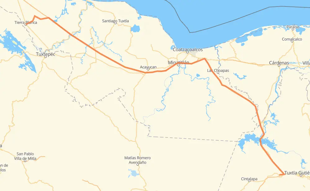
The distance from Ocozocuautla to Tierra Blanca is 289 miles by road including 133 miles on motorways. Road takes approximately 5 hours and 14 minutes and goes through Tres Valles, Ixhuatlán del Sureste, San Pedro Mártir, Novara and Colonia Adolfo Ruiz Cortines (Colonia Obrera).
| Shortest distance by air | 229 mi ✈️ |
| Car route length | 288.9 mi 🚗 |
| Driving time | 5 h 14 min |
| Fuel amount | 9.8 gal |
| Fuel cost | 38.6 USD |
| Toll roads cost | 495 + ? MXN |
| Point | Distance | Time | Fuel | |
| Ocozocuautla | 0 mi | 00 min | 0.0 gal | |
|
MEX 190 MEX 180D 92 mi, 1 h 39 min
|
||||
| Llano Verde | 92 mi | 1 h 39 min | 3.0 gal | |
|
MEX 180D 37 mi, 41 min
|
||||
| San Juan de los Reyes (Los Caimanes) | 129 mi | 2 h 20 min | 4.3 gal | |
|
MEX 180 4 mi, 04 min
|
||||
| Nuevo Teapa | 133 mi | 2 h 25 min | 4.5 gal | |
|
MEX 180D 6 mi, 06 min
|
||||
| Ixhuatlán del Sureste | 139 mi | 2 h 31 min | 4.6 gal | |
|
MEX 180D 17 mi, 18 min
|
||||
| San Pedro Mártir | 156 mi | 2 h 50 min | 5.2 gal | |
|
MEX 145D 86 mi, 1 h 24 min
|
||||
| Pichoapa | 242 mi | 4 h 14 min | 8.2 gal | |
|
MEX 145D 34 mi, 39 min
|
||||
| El Jícaro | 276 mi | 4 h 53 min | 9.0 gal | |
|
13 mi, 20 min
|
||||
| Tierra Blanca | 289 mi | 5 h 14 min | 9.8 gal | |
Frequently Asked Questions
How many toll booths are there from Ocozocuautla to Tierra Blanca?
There are 6 toll booths between Ocozocuautla and Tierra Blanca: Cosamaloapan, Acayucan, Antonio Dovali, Las Choapas, Ocozocoautla 182 and Malpasito.
How much does the toll booths cost from Ocozocuautla to Tierra Blanca?
Toll roads cost: Ocozocoautla 182 (82 MXN) + Malpasito (82 MXN) + Las Choapas (82 MXN) + Antonio Dovali (20 MXN) + Acayucan (?) + Cosamaloapan (229 MXN) = 495 + ? MXN
How much does it cost to drive from Ocozocuautla to Tierra Blanca?
Fuel cost: 38.6 USD
This fuel cost is calculated as: (Route length 288.9 mi) / (Fuel consumption 29.4 mpg) * (Fuel price 3.93 USD / gal)
You can adjust fuel consumption and fuel price here.
Toll roads cost: 495 + ? MXN
How long is a car ride from Ocozocuautla to Tierra Blanca?
Driving time: 5 h 14 min
This time is calculated for driving at the maximum permitted speed, taking into account traffic rules restrictions.
- 114 mi with a maximum speed 62 mph = 1 h 49 min
- 116 mi with a maximum speed 56 mph = 2 h 4 min
- 38 mi with a maximum speed 50 mph = 45 min
- 21 mi with a maximum speed 37 mph = 32 min
- 1 mi with a maximum speed 25 mph = 2 min
The calculated driving time does not take into account intermediate stops and traffic jams.
How far is Ocozocuautla to Tierra Blanca by land?
The distance between Ocozocuautla and Tierra Blanca is 288.9 mi by road including 133 mi on motorways.
Precise satellite coordinates of highways were used for this calculation. The start and finish points are the centers of Ocozocuautla and Tierra Blanca respectively.
How far is Ocozocuautla to Tierra Blanca by plane?
The shortest distance (air line, as the crow flies) between Ocozocuautla and Tierra Blanca is 228.7 mi.
This distance is calculated using the Haversine formula as a great-circle distance between two points on the surface of a sphere. The start and finish points are the centers of Ocozocuautla and Tierra Blanca respectively. Actual distance between airports may be different.
How many hours is Ocozocuautla from Tierra Blanca by plane?
Boeing 737 airliner needs 27 min to cover the distance of 229 mi at a cruising speed of 497 mph.
Small plane "Cessna 172" needs 1 h 40 min to flight this distance at average speed of 136 mph.
This time is approximate and do not take into account takeoff and landing times, airport location and other real world factors.
How long is a helicopter ride from Ocozocuautla to Tierra Blanca?
Fast helicopter "Eurocopter AS350" or "Hughes OH-6 Cayuse" need 1 h 32 min to cover the distance of 229 mi at a cruising speed of 149 mph.
Popular "Robinson R44" needs 1 h 45 min to flight this distance at average speed of 130 mph.
This time is approximate and do not take into account takeoff and landing times, aerodrome location and other real world factors.
What city is halfway between Ocozocuautla and Tierra Blanca?
The halfway point between Ocozocuautla and Tierra Blanca is Ixhuatlán del Sureste. It is located about 6 mi from the exact midpoint by road.
The distance from Ixhuatlán del Sureste to Ocozocuautla is 139 mi and driving will take about 2 h 31 min. The road between Ixhuatlán del Sureste and Tierra Blanca has length 150 mi and will take approximately 2 h 43 min.
The other cities located close to halfway point:
Where is Ocozocuautla in relation to Tierra Blanca?
Ocozocuautla is located 229 mi south-east of Tierra Blanca.
Ocozocuautla has geographic coordinates: latitude 16.7596, longitude -93.37388.
Tierra Blanca has geographic coordinates: latitude 18.45053, longitude -96.35498.
Which highway goes from Ocozocuautla to Tierra Blanca?
The route from Ocozocuautla to Tierra Blanca follows MEX 180D, MEX 145D.
Other minor sections pass along the road:
- MEX 180: 4 mi
- MEX 190: 4 mi
- MEX 145: 1 mi