Distance between Oriental and Ciudad Valles
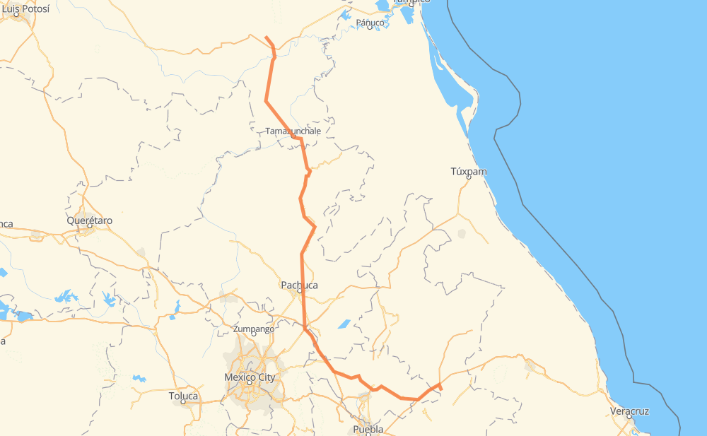
The distance from Oriental to Ciudad Valles is 314 miles by road including 31 miles on motorways. Road takes approximately 6 hours and 45 minutes and goes through Pachuca, Santiago Tolman, San Miguel Atepoxco, Fray Bernardino de Sahagún (Ciudad Sahagún), La Providencia, Tamazunchale and Matlapa.
| Shortest distance by air | 202 mi ✈️ |
| Car route length | 314.4 mi 🚗 |
| Driving time | 6 h 45 min |
| Fuel amount | 10.7 gal |
| Fuel cost | 42 USD |
| Toll roads cost | 0 + ? |
| Point | Distance | Time | Fuel | |
| Oriental | 0 mi | 00 min | 0.0 gal | |
|
MEX 129 3 mi, 03 min
|
||||
| San Antonio Virreyes | 3 mi | 03 min | 0.1 gal | |
|
MEX 129 MEX 136 80 mi, 1 h 25 min
|
||||
| José María Morelos (San José) | 83 mi | 1 h 29 min | 2.6 gal | |
|
MEX M40D 14 mi, 14 min
|
||||
| Santiago Tolman | 97 mi | 1 h 44 min | 3.3 gal | |
|
MEX 132 10 mi, 12 min
|
||||
| Zempoala | 107 mi | 1 h 56 min | 3.4 gal | |
|
18 mi, 20 min
|
||||
| Pachuca | 125 mi | 2 h 17 min | 4.1 gal | |
|
MEX 105 147 mi, 3 h 09 min
|
||||
| Tamazunchale | 272 mi | 5 h 26 min | 9.1 gal | |
|
MEX 85 10 mi, 11 min
|
||||
| Matlapa | 282 mi | 5 h 38 min | 9.4 gal | |
|
MEX 85 25 mi, 29 min
|
||||
| Tancahuitz de Santos | 306 mi | 6 h 08 min | 10.1 gal | |
|
MEX 85 29 mi, 37 min
|
||||
| Ciudad Valles | 336 mi | 6 h 45 min | 11.2 gal | |
Hotels of Ciudad Valles
Frequently Asked Questions
How many toll booths are there from Oriental to Ciudad Valles?
There are 2 toll booths between Oriental and Ciudad Valles: Tulancingo and Sanctorum.
How much does the toll booths cost from Oriental to Ciudad Valles?
Toll roads cost: Sanctorum (?) + Tulancingo (?) = 0 + ?
How much does it cost to drive from Oriental to Ciudad Valles?
Fuel cost: 42 USD
This fuel cost is calculated as: (Route length 314.4 mi) / (Fuel consumption 29.4 mpg) * (Fuel price 3.93 USD / gal)
You can adjust fuel consumption and fuel price here.
Toll roads cost: 0 + ?
How long is a car ride from Oriental to Ciudad Valles?
Driving time: 6 h 45 min
This time is calculated for driving at the maximum permitted speed, taking into account traffic rules restrictions.
- 17 mi with a maximum speed 62 mph = 16 min
- 75 mi with a maximum speed 56 mph = 1 h 20 min
- 6 mi with a maximum speed 56 mph = 6 min
- 217 mi with a maximum speed 50 mph = 4 h 22 min
- 19 mi with a maximum speed 31 mph = 35 min
- 1 mi with a maximum speed 25 mph = 3 min
The calculated driving time does not take into account intermediate stops and traffic jams.
How far is Oriental to Ciudad Valles by land?
The distance between Oriental and Ciudad Valles is 314.4 mi by road including 31.1 mi on motorways.
Precise satellite coordinates of highways were used for this calculation. The start and finish points are the centers of Oriental and Ciudad Valles respectively.
How far is Oriental to Ciudad Valles by plane?
The shortest distance (air line, as the crow flies) between Oriental and Ciudad Valles is 201.9 mi.
This distance is calculated using the Haversine formula as a great-circle distance between two points on the surface of a sphere. The start and finish points are the centers of Oriental and Ciudad Valles respectively. Actual distance between airports may be different.
How many hours is Oriental from Ciudad Valles by plane?
Boeing 737 airliner needs 24 min to cover the distance of 202 mi at a cruising speed of 497 mph.
Small plane "Cessna 172" needs 1 h 28 min to flight this distance at average speed of 136 mph.
This time is approximate and do not take into account takeoff and landing times, airport location and other real world factors.
How long is a helicopter ride from Oriental to Ciudad Valles?
Fast helicopter "Eurocopter AS350" or "Hughes OH-6 Cayuse" need 1 h 21 min to cover the distance of 202 mi at a cruising speed of 149 mph.
Popular "Robinson R44" needs 1 h 32 min to flight this distance at average speed of 130 mph.
This time is approximate and do not take into account takeoff and landing times, aerodrome location and other real world factors.
What city is halfway between Oriental and Ciudad Valles?
The halfway point between Oriental and Ciudad Valles is Cacalome (Acalome). It is located about 7 mi from the exact midpoint by road.
The distance from Cacalome (Acalome) to Oriental is 165 mi and driving will take about 3 h 4 min. The road between Cacalome (Acalome) and Ciudad Valles has length 150 mi and will take approximately 3 h 40 min.
The other cities located close to halfway point:
Where is Oriental in relation to Ciudad Valles?
Oriental is located 202 mi south-east of Ciudad Valles.
Oriental has geographic coordinates: latitude 19.37567, longitude -97.6196.
Ciudad Valles has geographic coordinates: latitude 21.99166, longitude -99.0103.
Which highway goes from Oriental to Ciudad Valles?
The route from Oriental to Ciudad Valles follows MEX 105.
Other minor sections pass along the road:
- MEX 85: 61 mi
- MEX 136: 51 mi
- MEX M40D: 27 mi
- MEX 140D: 13 mi
- MEX 102: 5 mi
- MEX 132: 4 mi
- MEX 129: 4 mi