Distance between Port Huron MI and Medicine Hat AB
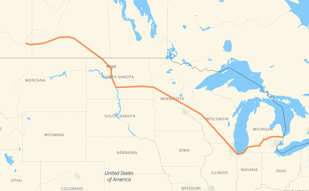
The distance from Port Huron to Medicine Hat is 1,785 miles by road including 1,163 miles on motorways. Road takes approximately 29 hours and 3 minutes and goes through Flint, Lansing, Kalamazoo, Chicago, Janesville, Madison and Eau Claire.
You can adjust fuel consumption and fuel price here.
How long is a car ride from Port Huron to Medicine Hat?
Driving time:
29 h 3 min
This time is calculated for driving at the maximum permitted speed, taking into account traffic rules restrictions.
1,026 mi with a maximum speed 68 mph = 15 h 5 min
20 mi with a maximum speed 65 mph = 18 min
53 mi with a maximum speed 62 mph = 51 min
31 mi with a maximum speed 60 mph = 31 min
399 mi with a maximum speed 56 mph = 7 h 7 min
18 mi with a maximum speed 55 mph = 19 min
233 mi with a maximum speed 50 mph = 4 h 41 min
2 mi with a maximum speed 45 mph = 2 min
4 mi with a maximum speed 31 mph = 7 min
The calculated driving time does not take into account intermediate stops and traffic jams.
How far is Port Huron to Medicine Hat by land?
The distance between Port Huron and Medicine Hat is 1,785.2 mi by road including 1,163.2 mi on motorways.
Precise satellite coordinates of highways were used for this calculation. The start and finish points are the centers of Port Huron and Medicine Hat respectively.
How far is Port Huron to Medicine Hat by plane?
The shortest distance (air line, as the crow flies) between Port Huron and Medicine Hat is 1,418.6 mi.
This distance is calculated using the Haversine formula as a great-circle distance between two points on the surface of a sphere. The start and finish points are the centers of Port Huron and Medicine Hat respectively. Actual distance between airports may be different.
How many hours is Port Huron from Medicine Hat by plane?
Boeing 737 airliner needs 2 h 51 min to cover the distance of 1,419 mi at a cruising speed of 497 mph.
Small plane "Cessna 172" needs 10 h 22 min to flight this distance at average speed of 136 mph.
This time is approximate and do not take into account takeoff and landing times, airport location and other real world factors.
How long is a helicopter ride from Port Huron to Medicine Hat?
Fast helicopter "Eurocopter AS350" or "Hughes OH-6 Cayuse" need 9 h 30 min to cover the distance of 1,419 mi at a cruising speed of 149 mph.
Popular "Robinson R44" needs 10 h 52 min to flight this distance at average speed of 130 mph.
This time is approximate and do not take into account takeoff and landing times, aerodrome location and other real world factors.
What city is halfway between Port Huron and Medicine Hat?
The halfway point between Port Huron and Medicine Hat is Alexandria. It is located about 17 mi from the exact midpoint by road.
The distance from Alexandria to Port Huron is 876 mi and driving will take about 13 h 11 min. The road between Alexandria and Medicine Hat has length 909 mi and will take approximately 15 h 51 min.
The other cities located close to halfway point:
Fergus Falls is in 923 mi from Port Huron and 862 mi from Medicine Hat
Melrose is in 844 mi from Port Huron and 941 mi from Medicine Hat
Freeport is in 836 mi from Port Huron and 949 mi from Medicine Hat
Where is Port Huron in relation to Medicine Hat?
Port Huron is located 1,419 mi east of Medicine Hat.
Port Huron has geographic coordinates: latitude 42.98159, longitude -82.44048.
Medicine Hat has geographic coordinates: latitude 50.04303, longitude -110.67902.
Which highway goes from Port Huron to Medicine Hat?
The route from Port Huron to Medicine Hat follows I 94, I 90, 1, US 52, I 69, 39, US 83, I 39.