Distance between Porto Grande and Sacramento
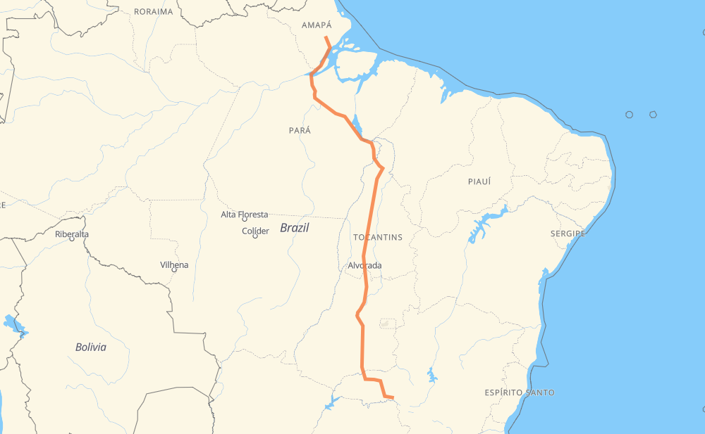
The distance from Porto Grande to Sacramento is 1,834 miles by road including 290 miles on motorways. Road takes approximately 48 hours and 7 minutes and goes through Maraba, Goiânia, Uberlândia, Picarreira, Vila Residencial Belo Monte, Serrano II and Santana.
| Shortest distance by air | 1,447 mi ✈️ |
| Car route length | 1,833.7 mi 🚗 |
| Driving time | 48 h 7 min |
| Fuel amount | 62.4 gal |
| Fuel cost | 245.1 USD |
| Point | Distance | Time | Fuel | |
| 0.70284, -51.40416 | 0 mi | 00 min | 0.0 gal | |
|
BR-210 72 mi, 1 h 18 min
|
||||
| Picarreira | 72 mi | 1 h 18 min | 4.8 gal | |
|
AP-010 BR-230 274 mi, 19 h 53 min
|
||||
| Vila Residencial Belo Monte | 346 mi | 21 h 11 min | 14.1 gal | |
|
BR-230 277 mi, 5 h 13 min
|
||||
| Maraba | 623 mi | 26 h 25 min | 23.4 gal | |
|
BR-230 BR-153 391 mi, 7 h 16 min
|
||||
| Serrano II | 1,014 mi | 33 h 41 min | 36.8 gal | |
|
BR-153 11 mi, 12 min
|
||||
| Santana | 1,025 mi | 33 h 53 min | 37.0 gal | |
|
BR-153 216 mi, 3 h 55 min
|
||||
| Setor Galiléia | 1,241 mi | 37 h 48 min | 44.3 gal | |
|
BR-153 247 mi, 4 h 38 min
|
||||
| Chácara Bom Retiro | 1,488 mi | 42 h 26 min | 52.8 gal | |
|
GO-080 13 mi, 15 min
|
||||
| Goiânia | 1,501 mi | 42 h 42 min | 53.4 gal | |
|
BR-153 221 mi, 3 h 30 min
|
||||
| Uberlândia | 1,722 mi | 46 h 12 min | 60.9 gal | |
|
BR-050 114 mi, 1 h 54 min
|
||||
| Sacramento | 1,836 mi | 48 h 07 min | 64.4 gal | |
Frequently Asked Questions
How much does it cost to drive from Porto Grande to Sacramento?
Fuel cost: 245.1 USD
This fuel cost is calculated as: (Route length 1,833.7 mi) / (Fuel consumption 29.4 mpg) * (Fuel price 3.93 USD / gal)
You can adjust fuel consumption and fuel price here.
How long is a car ride from Porto Grande to Sacramento?
Driving time: 48 h 7 min
This time is calculated for driving at the maximum permitted speed, taking into account traffic rules restrictions.
- 229 mi with a maximum speed 68 mph = 3 h 21 min
- 22 mi with a maximum speed 62 mph = 21 min
- 906 mi with a maximum speed 56 mph = 16 h 10 min
- 430 mi with a maximum speed 50 mph = 8 h 38 min
- 5 mi with a maximum speed 37 mph = 8 min
- 1 mi with a maximum speed 31 mph = 1 min
- 4 mi with a maximum speed 25 mph = 8 min
- 240 mi with a maximum speed 12 mph = 19 h 16 min
The calculated driving time does not take into account intermediate stops and traffic jams.
How far is Porto Grande to Sacramento by land?
The distance between Porto Grande and Sacramento is 1,833.7 mi by road including 289.6 mi on motorways.
Precise satellite coordinates of highways were used for this calculation. The start and finish points are the centers of Porto Grande and Sacramento respectively.
How far is Porto Grande to Sacramento by plane?
The shortest distance (air line, as the crow flies) between Porto Grande and Sacramento is 1,446.6 mi.
This distance is calculated using the Haversine formula as a great-circle distance between two points on the surface of a sphere. The start and finish points are the centers of Porto Grande and Sacramento respectively. Actual distance between airports may be different.
How many hours is Porto Grande from Sacramento by plane?
Boeing 737 airliner needs 2 h 54 min to cover the distance of 1,447 mi at a cruising speed of 497 mph.
Small plane "Cessna 172" needs 10 h 34 min to flight this distance at average speed of 136 mph.
This time is approximate and do not take into account takeoff and landing times, airport location and other real world factors.
How long is a helicopter ride from Porto Grande to Sacramento?
Fast helicopter "Eurocopter AS350" or "Hughes OH-6 Cayuse" need 9 h 42 min to cover the distance of 1,447 mi at a cruising speed of 149 mph.
Popular "Robinson R44" needs 11 h 5 min to flight this distance at average speed of 130 mph.
This time is approximate and do not take into account takeoff and landing times, aerodrome location and other real world factors.
What city is halfway between Porto Grande and Sacramento?
The halfway point between Porto Grande and Sacramento is Serrano II. It is located about 98 mi from the exact midpoint by road.
The distance from Serrano II to Porto Grande is 1,014 mi and driving will take about 33 h 40 min. The road between Serrano II and Sacramento has length 819 mi and will take approximately 14 h 26 min.
The other cities located close to halfway point:
Where is Porto Grande in relation to Sacramento?
Porto Grande is located 1,447 mi north of Sacramento.
Porto Grande has geographic coordinates: latitude 0.70284, longitude -51.40416.
Sacramento has geographic coordinates: latitude -19.8653, longitude -47.44027.
Which highway goes from Porto Grande to Sacramento?
The route from Porto Grande to Sacramento follows BR-153, BR-230, BR-050, GO-080.
Other minor sections pass along the road:
- BR-210: 60 mi
- BR-156: 57 mi
- BR-365: 52 mi
- BR-464: 32 mi
- TO-420: 24 mi
- BR-414: 22 mi
- BR-452: 19 mi
- AP-440: 5 mi
- AP-020: 4 mi
- AP-010: 3 mi
- BR-262: 3 mi
- BR-222: 1 mi