Distance between Porto Seguro and São Paulo
The distance from Porto Seguro to São Paulo is 944 miles by road including 354 miles on motorways. Road takes approximately 17 hours and 49 minutes and goes through Teixeira de Freitas, Teófilo Otoni, Coronel Fabriciano, Contagem, Betim and Atibaia.
| Shortest distance by air | 695 mi ✈️ |
| Car route length | 944.5 mi 🚗 |
| Driving time | 17 h 49 min |
| Fuel amount | 32.1 gal |
| Fuel cost | 126.3 USD |
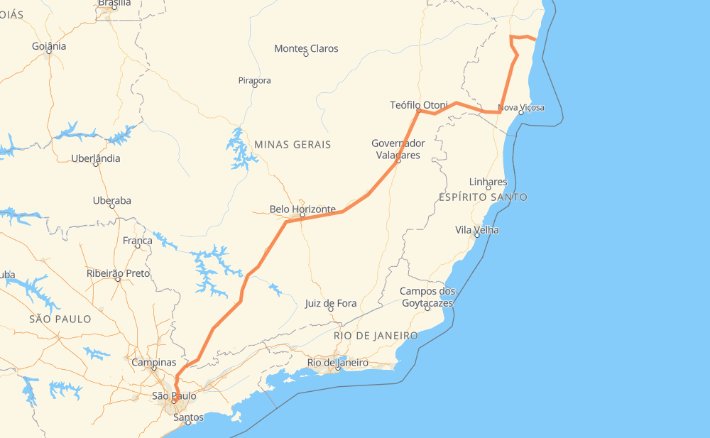
| Point | Distance | Time | Fuel | |
| Porto Seguro | 0 mi | 00 min | 0.0 gal | |
|
BR-367 BR-101 95 mi, 1 h 48 min
|
||||
| Itamaraju | 95 mi | 1 h 48 min | 3.1 gal | |
|
BR-101 44 mi, 49 min
|
||||
| Teixeira de Freitas | 139 mi | 2 h 37 min | 4.6 gal | |
|
BR-101 BR-418 68 mi, 1 h 21 min
|
||||
| Nanuque | 207 mi | 3 h 58 min | 6.8 gal | |
|
BR-418 96 mi, 1 h 57 min
|
||||
| Teófilo Otoni | 303 mi | 5 h 56 min | 10.3 gal | |
|
BR-116 154 mi, 3 h 06 min
|
||||
| Coronel Fabriciano | 457 mi | 9 h 02 min | 15.5 gal | |
|
BR-381 137 mi, 2 h 54 min
|
||||
| Contagem | 593 mi | 11 h 57 min | 20.1 gal | |
|
BR-381 10 mi, 10 min
|
||||
| Betim | 603 mi | 12 h 08 min | 20.4 gal | |
|
BR-381 305 mi, 4 h 53 min
|
||||
| Atibaia | 908 mi | 17 h 01 min | 30.6 gal | |
|
SP-010 BR-381 39 mi, 47 min
|
||||
| São Paulo | 947 mi | 17 h 48 min | 32.2 gal | |
Hotels of São Paulo
Frequently Asked Questions
How much does it cost to drive from Porto Seguro to São Paulo?
Fuel cost: 126.3 USD
This fuel cost is calculated as: (Route length 944.5 mi) / (Fuel consumption 29.4 mpg) * (Fuel price 3.93 USD / gal)
You can adjust fuel consumption and fuel price here.
How long is a car ride from Porto Seguro to São Paulo?
Driving time: 17 h 49 min
This time is calculated for driving at the maximum permitted speed, taking into account traffic rules restrictions.
- 186 mi with a maximum speed 68 mph = 2 h 43 min
- 70 mi with a maximum speed 62 mph = 1 h 7 min
- 230 mi with a maximum speed 56 mph = 4 h 6 min
- 31 mi with a maximum speed 56 mph = 33 min
- 365 mi with a maximum speed 50 mph = 7 h 21 min
- 4 mi with a maximum speed 43 mph = 5 min
- 42 mi with a maximum speed 37 mph = 1 h 6 min
- 4 mi with a maximum speed 31 mph = 8 min
- 14 mi with a maximum speed 25 mph = 34 min
The calculated driving time does not take into account intermediate stops and traffic jams.
How far is Porto Seguro to São Paulo by land?
The distance between Porto Seguro and São Paulo is 944.5 mi by road including 353.6 mi on motorways.
Precise satellite coordinates of highways were used for this calculation. The start and finish points are the centers of Porto Seguro and São Paulo respectively.
How far is Porto Seguro to São Paulo by plane?
The shortest distance (air line, as the crow flies) between Porto Seguro and São Paulo is 694.7 mi.
This distance is calculated using the Haversine formula as a great-circle distance between two points on the surface of a sphere. The start and finish points are the centers of Porto Seguro and São Paulo respectively. Actual distance between airports may be different.
How many hours is Porto Seguro from São Paulo by plane?
Boeing 737 airliner needs 1 h 23 min to cover the distance of 695 mi at a cruising speed of 497 mph.
Small plane "Cessna 172" needs 5 h 4 min to flight this distance at average speed of 136 mph.
This time is approximate and do not take into account takeoff and landing times, airport location and other real world factors.
How long is a helicopter ride from Porto Seguro to São Paulo?
Fast helicopter "Eurocopter AS350" or "Hughes OH-6 Cayuse" need 4 h 39 min to cover the distance of 695 mi at a cruising speed of 149 mph.
Popular "Robinson R44" needs 5 h 19 min to flight this distance at average speed of 130 mph.
This time is approximate and do not take into account takeoff and landing times, aerodrome location and other real world factors.
What city is halfway between Porto Seguro and São Paulo?
The halfway point between Porto Seguro and São Paulo is Severo. It is located about 4 mi from the exact midpoint by road.
The distance from Severo to Porto Seguro is 477 mi and driving will take about 9 h 25 min. The road between Severo and São Paulo has length 469 mi and will take approximately 8 h 23 min.
The other cities located close to halfway point:
Where is Porto Seguro in relation to São Paulo?
Porto Seguro is located 695 mi north-east of São Paulo.
Porto Seguro has geographic coordinates: latitude -16.44348, longitude -39.06425.
São Paulo has geographic coordinates: latitude -23.55065, longitude -46.63338.
Which highway goes from Porto Seguro to São Paulo?
The route from Porto Seguro to São Paulo follows BR-381, BR-418, BR-101, BR-116.
Other minor sections pass along the road:
- SP-010: 55 mi
- BR-367: 39 mi
- MGC-418: 19 mi
- BR-262: 12 mi
- LMG-776: 2 mi
- SP-060: 2 mi
- BR-494: 2 mi
- BR-342: 1 mi
- MG-434: 1 mi
- SP-015: 1 mi
- BR-050: 1 mi
- MG-129: 1 mi