Distance between Pozo Almonte and Asuncion
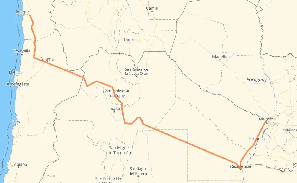
The distance from Pozo Almonte to Asuncion is 1,270 miles by road including 25 miles on motorways. Road takes approximately 24 hours and 22 minutes and goes through Calama, San Salvador de Jujuy, Presidencia Roque Sáenz Peña, Resistencia, Formosa and Lambaré.
| Shortest distance by air | 849 mi ✈️ |
| Car route length | 1,270.1 mi 🚗 |
| Driving time | 24 h 22 min |
| Fuel amount | 43.2 gal |
| Fuel cost | 169.8 USD |
| Point | Distance | Time | Fuel | |
| Pozo Almonte | 0 mi | 00 min | 0.0 gal | |
|
5 150 mi, 2 h 47 min
|
||||
| María Elena | 150 mi | 2 h 47 min | 3.5 gal | |
|
5 56 mi, 1 h 07 min
|
||||
| Calama | 206 mi | 3 h 54 min | 6.7 gal | |
|
23-CH 84 mi, 1 h 37 min
|
||||
| San Pedro de Atacama | 290 mi | 5 h 32 min | 7.3 gal | |
|
27-CH RN52 272 mi, 5 h 14 min
|
||||
| San Salvador de Jujuy | 562 mi | 10 h 46 min | 19.0 gal | |
|
RN9 RN16 426 mi, 8 h 14 min
|
||||
| Presidencia Roque Sáenz Peña | 988 mi | 19 h 01 min | 32.9 gal | |
|
RN16 93 mi, 1 h 45 min
|
||||
| Resistencia | 1,080 mi | 20 h 46 min | 36.6 gal | |
|
RN16 RN11 109 mi, 1 h 59 min
|
||||
| Formosa | 1,189 mi | 22 h 46 min | 40.3 gal | |
|
RN11 78 mi, 1 h 32 min
|
||||
| Lambaré | 1,267 mi | 24 h 18 min | 43.1 gal | |
|
3 mi, 04 min
|
||||
| Asuncion | 1,270 mi | 24 h 22 min | 43.1 gal | |
Hotels of Asuncion
Frequently Asked Questions
How much does it cost to drive from Pozo Almonte to Asuncion?
Fuel cost: 169.8 USD
This fuel cost is calculated as: (Route length 1,270.1 mi) / (Fuel consumption 29.4 mpg) * (Fuel price 3.93 USD / gal)
You can adjust fuel consumption and fuel price here.
How long is a car ride from Pozo Almonte to Asuncion?
Driving time: 24 h 22 min
This time is calculated for driving at the maximum permitted speed, taking into account traffic rules restrictions.
- 17 mi with a maximum speed 62 mph = 16 min
- 575 mi with a maximum speed 56 mph = 10 h 15 min
- 662 mi with a maximum speed 50 mph = 13 h 18 min
- 14 mi with a maximum speed 37 mph = 21 min
- 1 mi with a maximum speed 25 mph = 2 min
- 1 mi with a maximum speed 12 mph = 6 min
The calculated driving time does not take into account intermediate stops and traffic jams.
How far is Pozo Almonte to Asuncion by land?
The distance between Pozo Almonte and Asuncion is 1,270.1 mi by road including 25.5 mi on motorways.
Precise satellite coordinates of highways were used for this calculation. The start and finish points are the centers of Pozo Almonte and Asuncion respectively.
How far is Pozo Almonte to Asuncion by plane?
The shortest distance (air line, as the crow flies) between Pozo Almonte and Asuncion is 848.8 mi.
This distance is calculated using the Haversine formula as a great-circle distance between two points on the surface of a sphere. The start and finish points are the centers of Pozo Almonte and Asuncion respectively. Actual distance between airports may be different.
How many hours is Pozo Almonte from Asuncion by plane?
Boeing 737 airliner needs 1 h 42 min to cover the distance of 849 mi at a cruising speed of 497 mph.
Small plane "Cessna 172" needs 6 h 12 min to flight this distance at average speed of 136 mph.
This time is approximate and do not take into account takeoff and landing times, airport location and other real world factors.
How long is a helicopter ride from Pozo Almonte to Asuncion?
Fast helicopter "Eurocopter AS350" or "Hughes OH-6 Cayuse" need 5 h 41 min to cover the distance of 849 mi at a cruising speed of 149 mph.
Popular "Robinson R44" needs 6 h 30 min to flight this distance at average speed of 130 mph.
This time is approximate and do not take into account takeoff and landing times, aerodrome location and other real world factors.
What city is halfway between Pozo Almonte and Asuncion?
The halfway point between Pozo Almonte and Asuncion is Cabeza de Buey. It is located about 23 mi from the exact midpoint by road.
The distance from Cabeza de Buey to Pozo Almonte is 612 mi and driving will take about 11 h 40 min. The road between Cabeza de Buey and Asuncion has length 658 mi and will take approximately 12 h 42 min.
The other cities located close to halfway point:
Where is Pozo Almonte in relation to Asuncion?
Pozo Almonte is located 849 mi north-west of Asuncion.
Pozo Almonte has geographic coordinates: latitude -20.25971, longitude -69.78614.
Asuncion has geographic coordinates: latitude -25.29599, longitude -57.63112.
Which highway goes from Pozo Almonte to Asuncion?
The route from Pozo Almonte to Asuncion follows RN16, RN11, RN52, 5, 27-CH, RN9, RN34.
Other minor sections pass along the road:
- 23-CH: 58 mi
- 24: 52 mi
- RN66: 16 mi
- RN1V66: 7 mi
- RNA011: 7 mi
- 25: 3 mi
- B-241: 1 mi