Distance between Ricardo Flores Magón and Los Chinos
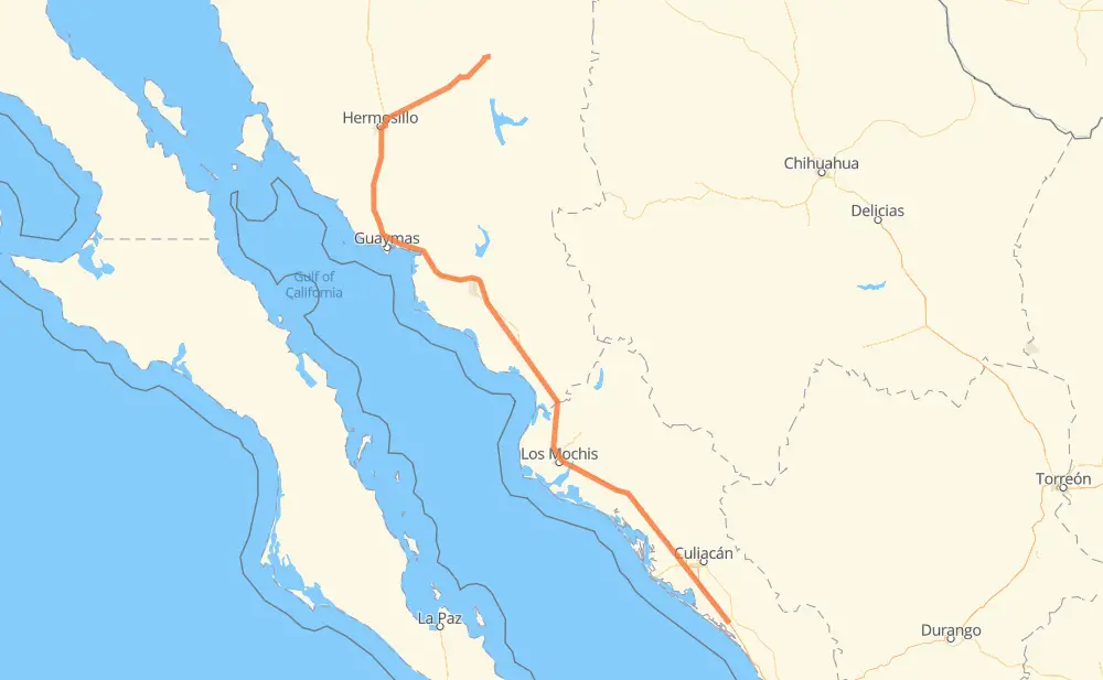
The distance from Ricardo Flores Magón to Los Chinos is 574 miles by road including 418 miles on motorways. Road takes approximately 10 hours and 34 minutes and goes through Gabriel Leyva Solano, Los Mochis, Navojoa, Hermosillo and Heroica Ciudad de Ures.
You can adjust fuel consumption and fuel price here.
Toll roads cost:
646 + ? MXN
How long is a car ride from Ricardo Flores Magón to Los Chinos?
Driving time:
10 h 34 min
This time is calculated for driving at the maximum permitted speed, taking into account traffic rules restrictions.
101 mi with a maximum speed 68 mph = 1 h 28 min
126 mi with a maximum speed 62 mph = 2 h 2 min
11 mi with a maximum speed 56 mph = 12 min
40 mi with a maximum speed 56 mph = 42 min
274 mi with a maximum speed 50 mph = 5 h 30 min
17 mi with a maximum speed 37 mph = 26 min
3 mi with a maximum speed 31 mph = 5 min
1 mi with a maximum speed 25 mph = 2 min
1 mi with a maximum speed 12 mph = 3 min
The calculated driving time does not take into account intermediate stops and traffic jams.
How far is Ricardo Flores Magón to Los Chinos by land?
The distance between Ricardo Flores Magón and Los Chinos is 573.5 mi by road including 418.2 mi on motorways.
Precise satellite coordinates of highways were used for this calculation. The start and finish points are the centers of Ricardo Flores Magón and Los Chinos respectively.
How far is Ricardo Flores Magón to Los Chinos by plane?
The shortest distance (air line, as the crow flies) between Ricardo Flores Magón and Los Chinos is 419.4 mi.
This distance is calculated using the Haversine formula as a great-circle distance between two points on the surface of a sphere. The start and finish points are the centers of Ricardo Flores Magón and Los Chinos respectively. Actual distance between airports may be different.
How many hours is Ricardo Flores Magón from Los Chinos by plane?
Boeing 737 airliner needs 50 min to cover the distance of 419 mi at a cruising speed of 497 mph.
Small plane "Cessna 172" needs 3 h 4 min to flight this distance at average speed of 136 mph.
This time is approximate and do not take into account takeoff and landing times, airport location and other real world factors.
How long is a helicopter ride from Ricardo Flores Magón to Los Chinos?
Fast helicopter "Eurocopter AS350" or "Hughes OH-6 Cayuse" need 2 h 48 min to cover the distance of 419 mi at a cruising speed of 149 mph.
Popular "Robinson R44" needs 3 h 12 min to flight this distance at average speed of 130 mph.
This time is approximate and do not take into account takeoff and landing times, aerodrome location and other real world factors.
What city is halfway between Ricardo Flores Magón and Los Chinos?
The halfway point between Ricardo Flores Magón and Los Chinos is Buenos Aires. It is located about 2 mi from the exact midpoint by road.
The distance from Buenos Aires to Ricardo Flores Magón is 285 mi and driving will take about 5 h 14 min. The road between Buenos Aires and Los Chinos has length 288 mi and will take approximately 5 h 20 min.
The other cities located close to halfway point:
Alinsumos is in 291 mi from Ricardo Flores Magón and 283 mi from Los Chinos
Agiabampo is in 281 mi from Ricardo Flores Magón and 292 mi from Los Chinos
Empaque de Juan Carlos Cuevas is in 280 mi from Ricardo Flores Magón and 294 mi from Los Chinos
Where is Ricardo Flores Magón in relation to Los Chinos?
Ricardo Flores Magón is located 419 mi south-east of Los Chinos.
Ricardo Flores Magón has geographic coordinates: latitude 24.17939, longitude -107.1056.
Los Chinos has geographic coordinates: latitude 29.76783, longitude -109.75067.
Which highway goes from Ricardo Flores Magón to Los Chinos?
The route from Ricardo Flores Magón to Los Chinos follows MEX 15D, MEX 14.