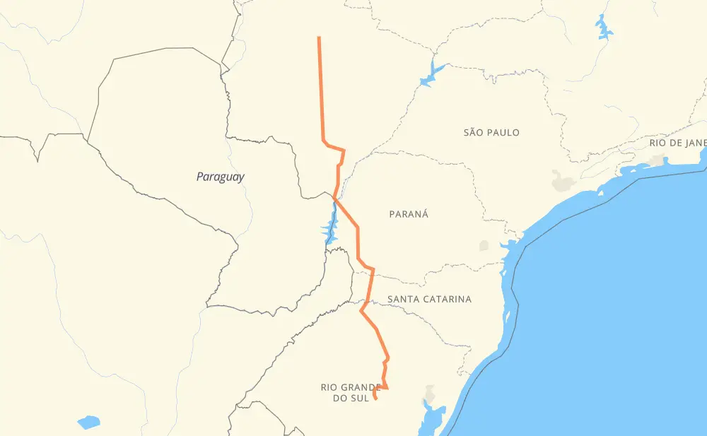
Distance between Rio Verde de Mato Grosso and Cachoeira do Sul
The distance from Rio Verde de Mato Grosso to Cachoeira do Sul is 1,006 miles by road including 50 miles on motorways. Road takes approximately 19 hours and 6 minutes and goes through São Gabriel do Oeste, Nova Lima, Moradia do Sol, Chácara das Mansões, Nova Alvorada do Sul, Rio Brilhante and Naviraí.
| Shortest distance by air | 779 mi ✈️ |
| Car route length | 1,006 mi 🚗 |
| Driving time | 19 h 6 min |
| Fuel amount | 34.2 gal |
| Fuel cost | 134.5 USD |
| Point | Distance | Time | Fuel | |
| Rio Verde de Mato Grosso | 0 mi | 00 min | 0.0 gal | |
|
BR-163 42 mi, 45 min
|
||||
| São Gabriel do Oeste | 42 mi | 45 min | 1.3 gal | |
|
BR-163 78 mi, 1 h 27 min
|
||||
| Nova Lima | 119 mi | 2 h 13 min | 4.0 gal | |
|
BR-163 15 mi, 18 min
|
||||
| Moradia do Sol | 134 mi | 2 h 32 min | 4.5 gal | |
|
BR-163 12 mi, 14 min
|
||||
| Chácara das Mansões | 146 mi | 2 h 46 min | 4.7 gal | |
|
BR-163 56 mi, 1 h 02 min
|
||||
| Nova Alvorada do Sul | 203 mi | 3 h 49 min | 6.6 gal | |
|
BR-163 22 mi, 24 min
|
||||
| Rio Brilhante | 225 mi | 4 h 13 min | 7.6 gal | |
|
BR-163 MS-141 127 mi, 2 h 17 min
|
||||
| Naviraí | 352 mi | 6 h 30 min | 11.8 gal | |
|
MS-141 BR-163 27 mi, 31 min
|
||||
| Itaquiraí | 380 mi | 7 h 02 min | 12.8 gal | |
|
BR-163 38 mi, 43 min
|
||||
| Mundo Novo | 418 mi | 7 h 46 min | 14.1 gal | |
|
BR-163 591 mi, 11 h 20 min
|
||||
| -30.04808, -52.89015 | 1,008 mi | 19 h 06 min | 34.3 gal | |
Hotels of Cachoeira do Sul
Frequently Asked Questions
How much does it cost to drive from Rio Verde de Mato Grosso to Cachoeira do Sul?
Fuel cost: 134.5 USD
This fuel cost is calculated as: (Route length 1,006 mi) / (Fuel consumption 29.4 mpg) * (Fuel price 3.93 USD / gal)
You can adjust fuel consumption and fuel price here.
How long is a car ride from Rio Verde de Mato Grosso to Cachoeira do Sul?
Driving time: 19 h 6 min
This time is calculated for driving at the maximum permitted speed, taking into account traffic rules restrictions.
- 45 mi with a maximum speed 68 mph = 39 min
- 646 mi with a maximum speed 56 mph = 11 h 31 min
- 7 mi with a maximum speed 56 mph = 8 min
- 254 mi with a maximum speed 50 mph = 5 h 6 min
- 42 mi with a maximum speed 37 mph = 1 h 6 min
- 6 mi with a maximum speed 31 mph = 10 min
- 9 mi with a maximum speed 25 mph = 22 min
The calculated driving time does not take into account intermediate stops and traffic jams.
How far is Rio Verde de Mato Grosso to Cachoeira do Sul by land?
The distance between Rio Verde de Mato Grosso and Cachoeira do Sul is 1,006 mi by road including 50.3 mi on motorways.
Precise satellite coordinates of highways were used for this calculation. The start and finish points are the centers of Rio Verde de Mato Grosso and Cachoeira do Sul respectively.
How far is Rio Verde de Mato Grosso to Cachoeira do Sul by plane?
The shortest distance (air line, as the crow flies) between Rio Verde de Mato Grosso and Cachoeira do Sul is 779.2 mi.
This distance is calculated using the Haversine formula as a great-circle distance between two points on the surface of a sphere. The start and finish points are the centers of Rio Verde de Mato Grosso and Cachoeira do Sul respectively. Actual distance between airports may be different.
How many hours is Rio Verde de Mato Grosso from Cachoeira do Sul by plane?
Boeing 737 airliner needs 1 h 34 min to cover the distance of 779 mi at a cruising speed of 497 mph.
Small plane "Cessna 172" needs 5 h 42 min to flight this distance at average speed of 136 mph.
This time is approximate and do not take into account takeoff and landing times, airport location and other real world factors.
How long is a helicopter ride from Rio Verde de Mato Grosso to Cachoeira do Sul?
Fast helicopter "Eurocopter AS350" or "Hughes OH-6 Cayuse" need 5 h 13 min to cover the distance of 779 mi at a cruising speed of 149 mph.
Popular "Robinson R44" needs 5 h 58 min to flight this distance at average speed of 130 mph.
This time is approximate and do not take into account takeoff and landing times, aerodrome location and other real world factors.
What city is halfway between Rio Verde de Mato Grosso and Cachoeira do Sul?
The halfway point between Rio Verde de Mato Grosso and Cachoeira do Sul is Vista Alegre.
The distance from Vista Alegre to Rio Verde de Mato Grosso is 503 mi and driving will take about 9 h 17 min. The road between Vista Alegre and Cachoeira do Sul has length 503 mi and will take approximately 9 h 48 min.
The other cities located close to halfway point:
Where is Rio Verde de Mato Grosso in relation to Cachoeira do Sul?
Rio Verde de Mato Grosso is located 779 mi north of Cachoeira do Sul.
Rio Verde de Mato Grosso has geographic coordinates: latitude -18.91692, longitude -54.84107.
Cachoeira do Sul has geographic coordinates: latitude -30.04808, longitude -52.89015.
Which highway goes from Rio Verde de Mato Grosso to Cachoeira do Sul?
The route from Rio Verde de Mato Grosso to Cachoeira do Sul follows BR-163, BR-386, RSC-153, BR-060.
Other minor sections pass along the road:
- MS-141: 47 mi
- PR-182: 47 mi
- BR-467: 42 mi
- BR-153: 40 mi
- BR-376: 37 mi
- BR-158: 30 mi
- RSC-287: 26 mi
- RSC-471: 25 mi
- PR-180: 23 mi
- BR-267: 22 mi
- MS-475: 19 mi
- PR-483: 16 mi
- SC-160: 13 mi
- SC-492: 10 mi
- BR-262: 9 mi
- BR-487: 9 mi
- MS-147: 3 mi
- PR-317: 3 mi
- BR-282: 2 mi