Distance between Saint Joseph MN and Saint-Tite-des-Caps QC
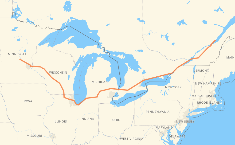
The distance from Saint Joseph to Saint-Tite-des-Caps is 1,518 miles by road including 1,493 miles on motorways. Road takes approximately 24 hours and goes through Eau Claire, Madison, Janesville, Chicago, Kalamazoo, Lansing and Flint.
You can adjust fuel consumption and fuel price here.
How long is a car ride from Saint Joseph to Saint-Tite-des-Caps?
Driving time:
24 h
This time is calculated for driving at the maximum permitted speed, taking into account traffic rules restrictions.
727 mi with a maximum speed 68 mph = 10 h 41 min
17 mi with a maximum speed 65 mph = 15 min
659 mi with a maximum speed 62 mph = 10 h 35 min
21 mi with a maximum speed 60 mph = 20 min
23 mi with a maximum speed 56 mph = 24 min
14 mi with a maximum speed 55 mph = 15 min
28 mi with a maximum speed 50 mph = 33 min
8 mi with a maximum speed 45 mph = 10 min
21 mi with a maximum speed 43 mph = 29 min
2 mi with a maximum speed 40 mph = 2 min
1 mi with a maximum speed 35 mph = 1 min
2 mi with a maximum speed 31 mph = 4 min
1 mi with a maximum speed 25 mph = 2 min
The calculated driving time does not take into account intermediate stops and traffic jams.
How far is Saint Joseph to Saint-Tite-des-Caps by land?
The distance between Saint Joseph and Saint-Tite-des-Caps is 1,518 mi by road including 1,492.5 mi on motorways.
Precise satellite coordinates of highways were used for this calculation. The start and finish points are the centers of Saint Joseph and Saint-Tite-des-Caps respectively.
How far is Saint Joseph to Saint-Tite-des-Caps by plane?
The shortest distance (air line, as the crow flies) between Saint Joseph and Saint-Tite-des-Caps is 1,124.1 mi.
This distance is calculated using the Haversine formula as a great-circle distance between two points on the surface of a sphere. The start and finish points are the centers of Saint Joseph and Saint-Tite-des-Caps respectively. Actual distance between airports may be different.
How many hours is Saint Joseph from Saint-Tite-des-Caps by plane?
Boeing 737 airliner needs 2 h 15 min to cover the distance of 1,124 mi at a cruising speed of 497 mph.
Small plane "Cessna 172" needs 8 h 13 min to flight this distance at average speed of 136 mph.
This time is approximate and do not take into account takeoff and landing times, airport location and other real world factors.
How long is a helicopter ride from Saint Joseph to Saint-Tite-des-Caps?
Fast helicopter "Eurocopter AS350" or "Hughes OH-6 Cayuse" need 7 h 32 min to cover the distance of 1,124 mi at a cruising speed of 149 mph.
Popular "Robinson R44" needs 8 h 36 min to flight this distance at average speed of 130 mph.
This time is approximate and do not take into account takeoff and landing times, aerodrome location and other real world factors.
What city is halfway between Saint Joseph and Saint-Tite-des-Caps?
The halfway point between Saint Joseph and Saint-Tite-des-Caps is Burton. It is located about 2 mi from the exact midpoint by road.
The distance from Burton to Saint Joseph is 757 mi and driving will take about 11 h 26 min. The road between Burton and Saint-Tite-des-Caps has length 761 mi and will take approximately 12 h 33 min.
The other cities located close to halfway point:
Flint is in 751 mi from Saint Joseph and 767 mi from Saint-Tite-des-Caps
Swartz Creek is in 742 mi from Saint Joseph and 776 mi from Saint-Tite-des-Caps
Gunnisonville is in 705 mi from Saint Joseph and 813 mi from Saint-Tite-des-Caps
Where is Saint Joseph in relation to Saint-Tite-des-Caps?
Saint Joseph is located 1,124 mi west of Saint-Tite-des-Caps.
Saint Joseph has geographic coordinates: latitude 45.56496, longitude -94.31832.
Saint-Tite-des-Caps has geographic coordinates: latitude 47.14163, longitude -70.77118.
Which highway goes from Saint Joseph to Saint-Tite-des-Caps?
The route from Saint Joseph to Saint-Tite-des-Caps follows I 94, 401, I 90, I 69, 20, I 39, 402.