Distance between Sainte Agathe MB and Wiarton ON

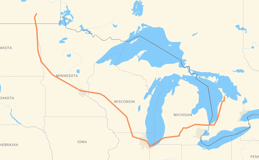
The distance from Sainte Agathe to Wiarton is 1,348 miles by road including 1,156 miles on motorways. Road takes approximately 21 hours and 42 minutes and goes through Grand Forks, Fargo, Eau Claire, Madison, Janesville, Chicago and Kalamazoo.

There are tolls on the route.
Shortest distance by air 823 mi ✈️
Car route length 1,348.4 mi 🚗
Driving time 21 h 42 min
Fuel amount 45.9 gal
Fuel cost 180.2 USD
Click here to load the interactive map
Compare this route in other services:
City
Town
Village
Hamlet
Motorway
Primary
Secondary
Unclassified
Point Distance Time Fuel
Sainte Agathe 0 mi 0:00 00 min 0.0 gal
PTH 75 I 29 121 mi, 2 h 11 min
Grand Forks 121 mi 2:11 2 h 11 min 3.9 gal
I 29 74 mi, 1 h 17 min
Fargo 194 mi 3:29 3 h 29 min 6.4 gal
I 29 I 94 327 mi, 5 h 03 min
Eau Claire 521 mi 8:32 8 h 32 min 17.5 gal
I 94 175 mi, 2 h 35 min
Madison 697 mi 11:07 11 h 07 min 23.5 gal
I 39 35 mi, 30 min
Janesville 731 mi 11:38 11 h 38 min 24.8 gal
I 39 I 90 107 mi, 1 h 39 min
Chicago 839 mi 13:18 13 h 18 min 28.0 gal
I 90 I 94 144 mi, 2 h 12 min
Kalamazoo 983 mi 15:30 15 h 30 min 33.4 gal
I 94 I 69 65 mi, 56 min
Lansing 1,048 mi 16:27 16 h 27 min 35.6 gal
I 69 62 mi, 54 min
Flint 1,109 mi 17:22 17 h 22 min 37.6 gal
I 69 76 mi, 1 h 14 min
Sarnia 1,185 mi 18:37 18 h 37 min 40.1 gal
402 21 163 mi, 3 h 05 min
Wiarton 1,348 mi 21:42 21 h 42 min 45.7 gal
City
Town
Village
Hamlet
Motorway
Primary
Secondary
Unclassified
Point Distance Time Fuel
Sainte Agathe 0 mi 0:00 00 min 0.0 gal
PTH 75 17 mi, 19 min
Morris 17 mi 0:19 19 min 0.6 gal
PTH 75 5 mi, 06 min
St. Jean-Baptiste 23 mi 0:25 25 min 0.6 gal
PTH 75 11 mi, 11 min
Letellier 34 mi 0:36 36 min 1.0 gal
PTH 75 11 mi, 12 min
Pembina 45 mi 0:49 49 min 1.5 gal
I 29 7 mi, 08 min
Joliette 52 mi 0:57 57 min 1.6 gal
I 29 9 mi, 11 min
Fleece 62 mi 1:09 1 h 09 min 2.0 gal
I 29 7 mi, 08 min
Pittsburgh 68 mi 1:17 1 h 17 min 2.2 gal
I 29 8 mi, 09 min
Drayton 76 mi 1:27 1 h 27 min 2.4 gal
I 29 34 mi, 33 min
Manvel 110 mi 2:00 2 h 00 min 3.6 gal
I 29 11 mi, 10 min
Grand Forks 121 mi 2:11 2 h 11 min 3.9 gal
I 29 38 mi, 37 min
Hillsboro 158 mi 2:48 2 h 48 min 5.3 gal
I 29 20 mi, 21 min
Brooktree Park 178 mi 3:10 3 h 10 min 5.7 gal
I 29 16 mi, 18 min
Fargo 194 mi 3:28 3 h 28 min 6.4 gal
I 29 8 mi, 08 min
Moorhead 203 mi 3:37 3 h 37 min 6.8 gal
I 94 53 mi, 50 min
Fergus Falls 255 mi 4:28 4 h 28 min 8.6 gal
I 94 47 mi, 44 min
Alexandria 303 mi 5:12 5 h 12 min 10.2 gal
I 94 32 mi, 28 min
Melrose 335 mi 5:41 5 h 41 min 11.3 gal
I 94 6 mi, 04 min
Freeport 341 mi 5:46 5 h 46 min 11.5 gal
I 94 11 mi, 09 min
Avon 352 mi 5:55 5 h 55 min 11.8 gal
I 94 6 mi, 05 min
Collegeville 357 mi 6:01 6 h 01 min 12.1 gal
I 94 3 mi, 02 min
Saint Joseph 360 mi 6:03 6 h 03 min 12.2 gal
I 94 23 mi, 20 min
Enfield 383 mi 6:24 6 h 24 min 12.9 gal
I 94 11 mi, 09 min
Monticello 395 mi 6:33 6 h 33 min 13.2 gal
I 94 9 mi, 08 min
Albertville 404 mi 6:42 6 h 42 min 13.7 gal
I 94 5 mi, 04 min
Rogers 409 mi 6:46 6 h 46 min 13.9 gal
I 94 6 mi, 05 min
Maple Grove 414 mi 6:51 6 h 51 min 13.9 gal
I 94 6 mi, 05 min
Brooklyn Park 421 mi 6:57 6 h 57 min 14.3 gal
I 94 3 mi, 02 min
Brooklyn Center 423 mi 7:00 7 h 00 min 14.3 gal
I 694 4 mi, 04 min
Fridley 428 mi 7:05 7 h 05 min 14.5 gal
I 694 3 mi, 03 min
Arden Hills 431 mi 7:09 7 h 09 min 14.6 gal
US 10 2 mi, 02 min
Shoreview 433 mi 7:11 7 h 11 min 14.7 gal
I 694 4 mi, 03 min
Vadnais Heights 437 mi 7:15 7 h 15 min 14.8 gal
I 694 2 mi, 02 min
White Bear Lake 439 mi 7:18 7 h 18 min 14.9 gal
I 694 4 mi, 04 min
Oakdale 444 mi 7:22 7 h 22 min 14.9 gal
I 694 7 mi, 06 min
Woodbury 450 mi 7:28 7 h 28 min 15.2 gal
I 94 9 mi, 07 min
Hudson 459 mi 7:36 7 h 36 min 15.6 gal
I 94 44 mi, 38 min
Menomonie 503 mi 8:15 8 h 15 min 17.0 gal
I 94 9 mi, 07 min
Elk Mound 511 mi 8:23 8 h 23 min 17.3 gal
I 94 10 mi, 08 min
Eau Claire 521 mi 8:31 8 h 31 min 17.5 gal
I 94 34 mi, 29 min
Northfield 555 mi 9:01 9 h 01 min 18.8 gal
I 94 9 mi, 08 min
Hixton 564 mi 9:09 9 h 09 min 19.1 gal
I 94 19 mi, 17 min
Millston 583 mi 9:26 9 h 26 min 19.7 gal
I 94 24 mi, 21 min
Oakdale 608 mi 9:48 9 h 48 min 20.6 gal
I 90 5 mi, 04 min
Camp Douglas 613 mi 9:52 9 h 52 min 20.8 gal
I 90 25 mi, 21 min
Wisconsin Dells 638 mi 10:14 10 h 14 min 21.4 gal
I 90 51 mi, 44 min
DeForest 688 mi 10:59 10 h 59 min 23.4 gal
I 39 9 mi, 07 min
Madison 697 mi 11:06 11 h 06 min 23.5 gal
I 39 21 mi, 18 min
Albion 718 mi 11:25 11 h 25 min 24.3 gal
I 39 14 mi, 12 min
Janesville 731 mi 11:37 11 h 37 min 24.8 gal
I 39 22 mi, 19 min
Machesney Park 754 mi 11:57 11 h 57 min 25.6 gal
I 39 11 mi, 09 min
Cherry Valley 764 mi 12:06 12 h 06 min 26.0 gal
I 90 4 mi, 03 min
Belvidere 768 mi 12:09 12 h 09 min 26.0 gal
I 90 11 mi, 09 min
Riley 779 mi 12:19 12 h 19 min 26.3 gal
I 90 14 mi, 12 min
Rutland Township 792 mi 12:31 12 h 31 min 26.8 gal
I 90 5 mi, 04 min
Wedgewood Acres 797 mi 12:35 12 h 35 min 27.1 gal
I 90 14 mi, 12 min
Schaumburg 812 mi 12:48 12 h 48 min 27.5 gal
I 90 4 mi, 03 min
Rolling Meadows 816 mi 12:52 12 h 52 min 27.7 gal
I 90 2 mi, 02 min
Mount Prospect 818 mi 12:54 12 h 54 min 27.8 gal
I 90 3 mi, 02 min
Des Plaines 821 mi 12:56 12 h 56 min 27.8 gal
I 90 2 mi, 02 min
Rosemont 823 mi 12:58 12 h 58 min 28.0 gal
I 90 16 mi, 18 min
Chicago 839 mi 13:17 13 h 17 min 28.0 gal
I 90 19 mi, 22 min
Hammond 859 mi 13:39 13 h 39 min 29.0 gal
I 90 10 mi, 09 min
Gary 869 mi 13:48 13 h 48 min 29.4 gal
I 90 6 mi, 05 min
Lake Station 875 mi 13:54 13 h 54 min 29.7 gal
I 90 4 mi, 03 min
Portage 879 mi 13:57 13 h 57 min 29.8 gal
I 94 18 mi, 16 min
Waterford 897 mi 14:13 14 h 13 min 30.4 gal
I 94 17 mi, 14 min
Hooks Corner 913 mi 14:28 14 h 28 min 31.0 gal
I 94 8 mi, 07 min
Bridgman 922 mi 14:36 14 h 36 min 31.3 gal
I 94 16 mi, 13 min
Benton Center 937 mi 14:49 14 h 49 min 31.8 gal
I 94 16 mi, 13 min
Watervliet 953 mi 15:03 15 h 03 min 32.1 gal
I 94 27 mi, 23 min
Portage 980 mi 15:27 15 h 27 min 33.3 gal
I 94 3 mi, 02 min
Kalamazoo 983 mi 15:29 15 h 29 min 33.4 gal
I 94 11 mi, 09 min
Battle Creek 994 mi 15:39 15 h 39 min 33.5 gal
I 94 16 mi, 14 min
Marshall 1,010 mi 15:53 15 h 53 min 34.3 gal
I 94 I 69 32 mi, 28 min
Potterville 1,042 mi 16:21 16 h 21 min 35.4 gal
I 69 2 mi, 02 min
West Windsor 1,044 mi 16:23 16 h 23 min 35.4 gal
I 69 3 mi, 02 min
Lansing 1,048 mi 16:26 16 h 26 min 35.6 gal
I 69 16 mi, 13 min
Gunnisonville 1,063 mi 16:40 16 h 40 min 36.1 gal
I 69 37 mi, 32 min
Swartz Creek 1,100 mi 17:13 17 h 13 min 37.3 gal
I 69 9 mi, 07 min
Flint 1,109 mi 17:21 17 h 21 min 37.6 gal
I 69 6 mi, 05 min
Burton 1,115 mi 17:27 17 h 27 min 37.9 gal
I 69 62 mi, 1 h 00 min
Port Huron 1,177 mi 18:27 18 h 27 min 40.0 gal
I 69 402 8 mi, 08 min
Sarnia 1,185 mi 18:36 18 h 36 min 40.1 gal
402 22 mi, 21 min
Forest 1,207 mi 18:57 18 h 57 min 41.0 gal
21 21 mi, 24 min
Grand Bend 1,228 mi 19:22 19 h 22 min 41.8 gal
21 11 mi, 13 min
Bayfield 1,239 mi 19:35 19 h 35 min 41.9 gal
21 16 mi, 18 min
Goderich 1,255 mi 19:54 19 h 54 min 42.4 gal
21 CR 1 26 mi, 29 min
Lucknow 1,281 mi 20:23 20 h 23 min 43.5 gal
CR 1 28 mi, 30 min
Paisley 1,309 mi 20:54 20 h 54 min 44.4 gal
CR 1 CR 17 19 mi, 22 min
Tara 1,328 mi 21:17 21 h 17 min 45.1 gal
CR 17 CR 10 13 mi, 15 min
Hepworth 1,341 mi 21:32 21 h 32 min 45.6 gal
6 2 mi, 03 min
Clavering 1,343 mi 21:35 21 h 35 min 45.6 gal
6 4 mi, 05 min
Wiarton 1,348 mi 21:41 21 h 41 min 45.7 gal

Frequently Asked Questions

How much does it cost to drive from Sainte Agathe to Wiarton?

Fuel cost: 180.2 USD

This fuel cost is calculated as: (Route length 1,348.4 mi) / (Fuel consumption 29.4 mpg) * (Fuel price 3.93 USD / gal)

You can adjust fuel consumption and fuel price here.

How long is a car ride from Sainte Agathe to Wiarton?

Driving time: 21 h 42 min

This time is calculated for driving at the maximum permitted speed, taking into account traffic rules restrictions.

  • 789 mi with a maximum speed 68 mph = 11 h 35 min
  • 17 mi with a maximum speed 65 mph = 15 min
  • 200 mi with a maximum speed 62 mph = 3 h 12 min
  • 21 mi with a maximum speed 60 mph = 20 min
  • 116 mi with a maximum speed 56 mph = 2 h 4 min
  • 25 mi with a maximum speed 55 mph = 27 min
  • 163 mi with a maximum speed 50 mph = 3 h 17 min
  • 8 mi with a maximum speed 45 mph = 10 min
  • 1 mi with a maximum speed 43 mph = 1 min
  • 1 mi with a maximum speed 37 mph = 1 min
  • 1 mi with a maximum speed 35 mph = 1 min
  • 6 mi with a maximum speed 31 mph = 10 min
  • 1 mi with a maximum speed 25 mph = 2 min

The calculated driving time does not take into account intermediate stops and traffic jams.

How far is Sainte Agathe to Wiarton by land?

The distance between Sainte Agathe and Wiarton is 1,348.4 mi by road including 1,156.4 mi on motorways.

Precise satellite coordinates of highways were used for this calculation. The start and finish points are the centers of Sainte Agathe and Wiarton respectively.

How far is Sainte Agathe to Wiarton by plane?

The shortest distance (air line, as the crow flies) between Sainte Agathe and Wiarton is 822.7 mi.

This distance is calculated using the Haversine formula as a great-circle distance between two points on the surface of a sphere. The start and finish points are the centers of Sainte Agathe and Wiarton respectively. Actual distance between airports may be different.

How many hours is Sainte Agathe from Wiarton by plane?

Boeing 737 airliner needs 1 h 39 min to cover the distance of 823 mi at a cruising speed of 497 mph.

Small plane "Cessna 172" needs 6 h 1 min to flight this distance at average speed of 136 mph.

This time is approximate and do not take into account takeoff and landing times, airport location and other real world factors.

How long is a helicopter ride from Sainte Agathe to Wiarton?

Fast helicopter "Eurocopter AS350" or "Hughes OH-6 Cayuse" need 5 h 31 min to cover the distance of 823 mi at a cruising speed of 149 mph.

Popular "Robinson R44" needs 6 h 18 min to flight this distance at average speed of 130 mph.

This time is approximate and do not take into account takeoff and landing times, aerodrome location and other real world factors.

What city is halfway between Sainte Agathe and Wiarton?

The halfway point between Sainte Agathe and Wiarton is DeForest. It is located about 14 mi from the exact midpoint by road.

The distance from DeForest to Sainte Agathe is 688 mi and driving will take about 10 h 59 min. The road between DeForest and Wiarton has length 660 mi and will take approximately 10 h 43 min.

The other cities located close to halfway point:

  • Madison is in 697 mi from Sainte Agathe and 651 mi from Wiarton
  • Wisconsin Dells is in 638 mi from Sainte Agathe and 711 mi from Wiarton
  • Albion is in 718 mi from Sainte Agathe and 631 mi from Wiarton

Where is Sainte Agathe in relation to Wiarton?

Sainte Agathe is located 823 mi north-west of Wiarton.

Sainte Agathe has geographic coordinates: latitude 49.56682, longitude -97.18204.

Wiarton has geographic coordinates: latitude 44.74074, longitude -81.13324.

Which highway goes from Sainte Agathe to Wiarton?

The route from Sainte Agathe to Wiarton follows I 94, I 90, I 69, I 29, US 81, I 39, 21.

Other minor sections pass along the road:

  • PTH 75: 43 mi
  • CR 1: 42 mi
  • I 694: 29 mi
  • 402: 21 mi
  • US 51: 20 mi
  • US 59: 11 mi
  • CR 3: 9 mi
  • CR 17: 9 mi
  • 6: 7 mi
  • CR 10: 6 mi
  • I 96: 4 mi
  • US 10: 4 mi
  • MN 95: 4 mi
  • US 12: 4 mi
  • 25: 4 mi
  • MN 210: 3 mi
  • US 52: 3 mi
  • US 31: 3 mi
  • WI 35: 2 mi
  • WI 11: 2 mi
Have any questions? Contact us!