Distance between San Buenaventura Nealtican and Campeche
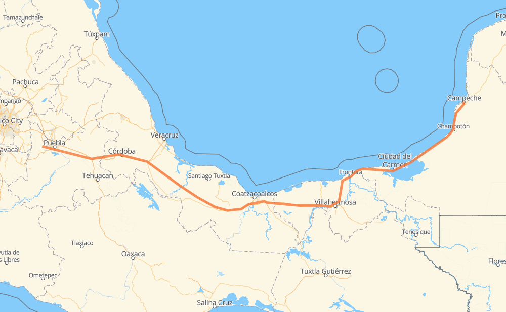
The distance from San Buenaventura Nealtican to Campeche is 644 miles by road including 367 miles on motorways. Road takes approximately 11 hours and 33 minutes and goes through Puebla, Orizaba, San Andrés Cholula, Acatzingo de Hidalgo, Palmarito Tochapan, Cuacnopalan and Maltrata.
| Shortest distance by air | 517 mi ✈️ |
| Car route length | 644.4 mi 🚗 |
| Driving time | 11 h 33 min |
| Fuel amount | 21.9 gal |
| Fuel cost | 85.5 USD |
| Toll roads cost | 919 + ? MXN |
| Point | Distance | Time | Fuel | |
| San Buenaventura Nealtican | 0 mi | 00 min | 0.0 gal | |
|
10 mi, 15 min
|
||||
| San Andrés Cholula | 10 mi | 15 min | 0.3 gal | |
|
Fed 190 7 mi, 09 min
|
||||
| Puebla | 17 mi | 25 min | 0.5 gal | |
|
MEX 150D 34 mi, 33 min
|
||||
| Acatzingo de Hidalgo | 50 mi | 59 min | 1.6 gal | |
|
MEX 150D 9 mi, 09 min
|
||||
| Palmarito Tochapan | 59 mi | 1 h 08 min | 1.9 gal | |
|
MEX 150D 8 mi, 09 min
|
||||
| Cuacnopalan | 67 mi | 1 h 17 min | 2.1 gal | |
|
MEX 150D 19 mi, 22 min
|
||||
| Maltrata | 86 mi | 1 h 40 min | 2.9 gal | |
|
MEX 150D 16 mi, 18 min
|
||||
| Nogales | 102 mi | 1 h 58 min | 3.4 gal | |
|
MEX 150D 4 mi, 05 min
|
||||
| Orizaba | 106 mi | 2 h 03 min | 3.5 gal | |
|
MEX 150D MEX 180 541 mi, 9 h 29 min
|
||||
| Campeche | 646 mi | 11 h 33 min | 21.9 gal | |
Hotels of Campeche
Frequently Asked Questions
How many toll booths are there from San Buenaventura Nealtican to Campeche?
There are 12 toll booths between San Buenaventura Nealtican and Campeche: Fortín, Cuitláhuac, Cosamaloapan, Acayucan, Antonio Dovali, Amozoc, Esperanza 27, Sánchez Magallanes, Villahermosa Nacajuca, Zacatal, Unidad and Seybaplaya.
How much does the toll booths cost from San Buenaventura Nealtican to Campeche?
Toll roads cost: Amozoc (72 MXN) + Esperanza 27 (140 MXN) + Fortín (33 MXN) + Cuitláhuac (114 MXN) + Cosamaloapan (229 MXN) + Acayucan (?) + Antonio Dovali (20 MXN) + Sánchez Magallanes (82 MXN) + Villahermosa Nacajuca (62 MXN) + Zacatal (90 MXN) + Unidad (?) + Seybaplaya (77 MXN) = 919 + ? MXN
How much does it cost to drive from San Buenaventura Nealtican to Campeche?
Fuel cost: 85.5 USD
This fuel cost is calculated as: (Route length 644.4 mi) / (Fuel consumption 29.4 mpg) * (Fuel price 3.9 USD / gal)
You can adjust fuel consumption and fuel price here.
Toll roads cost: 919 + ? MXN
How long is a car ride from San Buenaventura Nealtican to Campeche?
Driving time: 11 h 33 min
This time is calculated for driving at the maximum permitted speed, taking into account traffic rules restrictions.
- 78 mi with a maximum speed 68 mph = 1 h 9 min
- 202 mi with a maximum speed 62 mph = 3 h 15 min
- 77 mi with a maximum speed 56 mph = 1 h 22 min
- 54 mi with a maximum speed 56 mph = 57 min
- 225 mi with a maximum speed 50 mph = 4 h 31 min
- 7 mi with a maximum speed 37 mph = 12 min
- 2 mi with a maximum speed 31 mph = 4 min
The calculated driving time does not take into account intermediate stops and traffic jams.
How far is San Buenaventura Nealtican to Campeche by land?
The distance between San Buenaventura Nealtican and Campeche is 644.4 mi by road including 367.2 mi on motorways.
Precise satellite coordinates of highways were used for this calculation. The start and finish points are the centers of San Buenaventura Nealtican and Campeche respectively.
How far is San Buenaventura Nealtican to Campeche by plane?
The shortest distance (air line, as the crow flies) between San Buenaventura Nealtican and Campeche is 517 mi.
This distance is calculated using the Haversine formula as a great-circle distance between two points on the surface of a sphere. The start and finish points are the centers of San Buenaventura Nealtican and Campeche respectively. Actual distance between airports may be different.
How many hours is San Buenaventura Nealtican from Campeche by plane?
Boeing 737 airliner needs 1 h 2 min to cover the distance of 517 mi at a cruising speed of 497 mph.
Small plane "Cessna 172" needs 3 h 46 min to flight this distance at average speed of 136 mph.
This time is approximate and do not take into account takeoff and landing times, airport location and other real world factors.
How long is a helicopter ride from San Buenaventura Nealtican to Campeche?
Fast helicopter "Eurocopter AS350" or "Hughes OH-6 Cayuse" need 3 h 28 min to cover the distance of 517 mi at a cruising speed of 149 mph.
Popular "Robinson R44" needs 3 h 57 min to flight this distance at average speed of 130 mph.
This time is approximate and do not take into account takeoff and landing times, aerodrome location and other real world factors.
What city is halfway between San Buenaventura Nealtican and Campeche?
The halfway point between San Buenaventura Nealtican and Campeche is Nuevo Teapa (Santa Cecilia). It is located about 5 mi from the exact midpoint by road.
The distance from Nuevo Teapa (Santa Cecilia) to San Buenaventura Nealtican is 318 mi and driving will take about 5 h 31 min. The road between Nuevo Teapa (Santa Cecilia) and Campeche has length 327 mi and will take approximately 6 h 1 min.
The other cities located close to halfway point:
Where is San Buenaventura Nealtican in relation to Campeche?
San Buenaventura Nealtican is located 517 mi west of Campeche.
San Buenaventura Nealtican has geographic coordinates: latitude 19.05167, longitude -98.42889.
Campeche has geographic coordinates: latitude 19.84427, longitude -90.53621.
Which highway goes from San Buenaventura Nealtican to Campeche?
The route from San Buenaventura Nealtican to Campeche follows MEX 180, MEX 145D, MEX 150D, MEX 180D.
Other minor sections pass along the road:
- Fed 190: 2 mi