Distance between San Cayetano de Vacas and Benito Juárez (Chicalote)
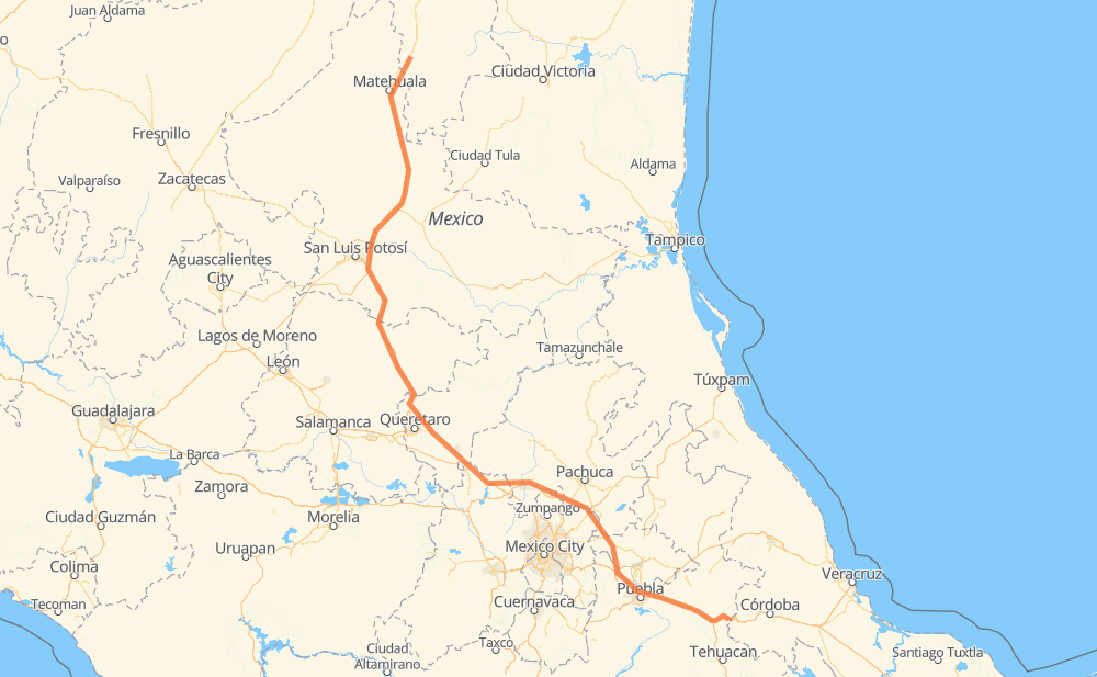
The distance from San Cayetano de Vacas to Benito Juárez (Chicalote) is 525 miles by road including 520 miles on motorways. Road takes approximately 9 hours and 8 minutes and goes through San Juan del Rio, Ejido La Yerba, Villa Hidalgo, Cerro de San Pedro, Delegación de La Pila, Santa María del Río and Parque Industrial Queretaro.
| Shortest distance by air | 406 mi ✈️ |
| Car route length | 525.1 mi 🚗 |
| Driving time | 9 h 8 min |
| Fuel amount | 17.9 gal |
| Fuel cost | 70.2 USD |
| Toll roads cost | 396 + ? MXN |
| Point | Distance | Time | Fuel | |
| San Cayetano de Vacas | 0 mi | 00 min | 0.0 gal | |
|
MEX 57 147 mi, 2 h 32 min
|
||||
| Delegación de La Pila | 147 mi | 2 h 32 min | 4.6 gal | |
|
MEX 57D MEX 57 99 mi, 1 h 40 min
|
||||
| Parque Industrial Queretaro | 247 mi | 4 h 12 min | 8.3 gal | |
|
MEX 57 MEX 57D 45 mi, 48 min
|
||||
| San Juan del Rio | 291 mi | 5 h 01 min | 9.8 gal | |
|
MEX 57 MEX M40D 152 mi, 2 h 31 min
|
||||
| Santa María Moyotzingo | 443 mi | 7 h 32 min | 15.0 gal | |
|
MEX 150D 7 mi, 07 min
|
||||
| San Miguel Xoxtla | 450 mi | 7 h 40 min | 15.2 gal | |
|
MEX 150D 5 mi, 05 min
|
||||
| San Francisco Ocotlán (Ocotlán) | 455 mi | 7 h 45 min | 15.5 gal | |
|
MEX 150D 39 mi, 40 min
|
||||
| Acatzingo de Hidalgo | 494 mi | 8 h 25 min | 16.7 gal | |
|
MEX 150D 9 mi, 09 min
|
||||
| Palmarito Tochapan | 503 mi | 8 h 35 min | 17.0 gal | |
|
MEX 150D 25 mi, 32 min
|
||||
| Benito Juárez (Chicalote) | 527 mi | 9 h 07 min | 17.9 gal | |
Frequently Asked Questions
How many toll booths are there from San Cayetano de Vacas to Benito Juárez (Chicalote)?
There are 10 toll booths between San Cayetano de Vacas and Benito Juárez (Chicalote): Matehuala Omega, Libramiento Oriente De SLP, Chichimequillas, Queretaro, Palmillas, San Martin Texmelucan, San Martín, Viaducto Elevado de Puebla, Amozoc and Esperanza 27.
How much does the toll booths cost from San Cayetano de Vacas to Benito Juárez (Chicalote)?
Toll roads cost: Matehuala Omega (?) + Libramiento Oriente De SLP (70 MXN) + Chichimequillas (51 MXN) + Palmillas (89 MXN) + Queretaro (?) + San Martin Texmelucan (?) + San Martín (42 MXN) + Viaducto Elevado de Puebla (?) + Amozoc (72 MXN) + Esperanza 27 (72 MXN) = 396 + ? MXN
How much does it cost to drive from San Cayetano de Vacas to Benito Juárez (Chicalote)?
Fuel cost: 70.2 USD
This fuel cost is calculated as: (Route length 525.1 mi) / (Fuel consumption 29.4 mpg) * (Fuel price 3.93 USD / gal)
You can adjust fuel consumption and fuel price here.
Toll roads cost: 396 + ? MXN
How long is a car ride from San Cayetano de Vacas to Benito Juárez (Chicalote)?
Driving time: 9 h 8 min
This time is calculated for driving at the maximum permitted speed, taking into account traffic rules restrictions.
- 47 mi with a maximum speed 68 mph = 40 min
- 263 mi with a maximum speed 62 mph = 4 h 14 min
- 108 mi with a maximum speed 56 mph = 1 h 56 min
- 99 mi with a maximum speed 50 mph = 1 h 59 min
- 3 mi with a maximum speed 43 mph = 3 min
- 6 mi with a maximum speed 31 mph = 12 min
The calculated driving time does not take into account intermediate stops and traffic jams.
How far is San Cayetano de Vacas to Benito Juárez (Chicalote) by land?
The distance between San Cayetano de Vacas and Benito Juárez (Chicalote) is 525.1 mi by road including 520.1 mi on motorways.
Precise satellite coordinates of highways were used for this calculation. The start and finish points are the centers of San Cayetano de Vacas and Benito Juárez (Chicalote) respectively.
How far is San Cayetano de Vacas to Benito Juárez (Chicalote) by plane?
The shortest distance (air line, as the crow flies) between San Cayetano de Vacas and Benito Juárez (Chicalote) is 405.8 mi.
This distance is calculated using the Haversine formula as a great-circle distance between two points on the surface of a sphere. The start and finish points are the centers of San Cayetano de Vacas and Benito Juárez (Chicalote) respectively. Actual distance between airports may be different.
How many hours is San Cayetano de Vacas from Benito Juárez (Chicalote) by plane?
Boeing 737 airliner needs 48 min to cover the distance of 406 mi at a cruising speed of 497 mph.
Small plane "Cessna 172" needs 2 h 58 min to flight this distance at average speed of 136 mph.
This time is approximate and do not take into account takeoff and landing times, airport location and other real world factors.
How long is a helicopter ride from San Cayetano de Vacas to Benito Juárez (Chicalote)?
Fast helicopter "Eurocopter AS350" or "Hughes OH-6 Cayuse" need 2 h 43 min to cover the distance of 406 mi at a cruising speed of 149 mph.
Popular "Robinson R44" needs 3 h 6 min to flight this distance at average speed of 130 mph.
This time is approximate and do not take into account takeoff and landing times, aerodrome location and other real world factors.
What city is halfway between San Cayetano de Vacas and Benito Juárez (Chicalote)?
The halfway point between San Cayetano de Vacas and Benito Juárez (Chicalote) is Ampliación Jesús María. It is located about 5 mi from the exact midpoint by road.
The distance from Ampliación Jesús María to San Cayetano de Vacas is 267 mi and driving will take about 4 h 36 min. The road between Ampliación Jesús María and Benito Juárez (Chicalote) has length 258 mi and will take approximately 4 h 31 min.
The other cities located close to halfway point:
Where is San Cayetano de Vacas in relation to Benito Juárez (Chicalote)?
San Cayetano de Vacas is located 406 mi north-west of Benito Juárez (Chicalote).
San Cayetano de Vacas has geographic coordinates: latitude 23.94736, longitude -100.4352.
Benito Juárez (Chicalote) has geographic coordinates: latitude 18.8338, longitude -97.3389.
Which highway goes from San Cayetano de Vacas to Benito Juárez (Chicalote)?
The route from San Cayetano de Vacas to Benito Juárez (Chicalote) follows MEX 57, MEX M40D, MEX 57D, MEX 150D.
Other minor sections pass along the road:
- MEX 80: 51 mi
- MEX 45: 25 mi
- MEX 120: 7 mi