Distance between San Francisco Pujiltic and Puerto Morelos
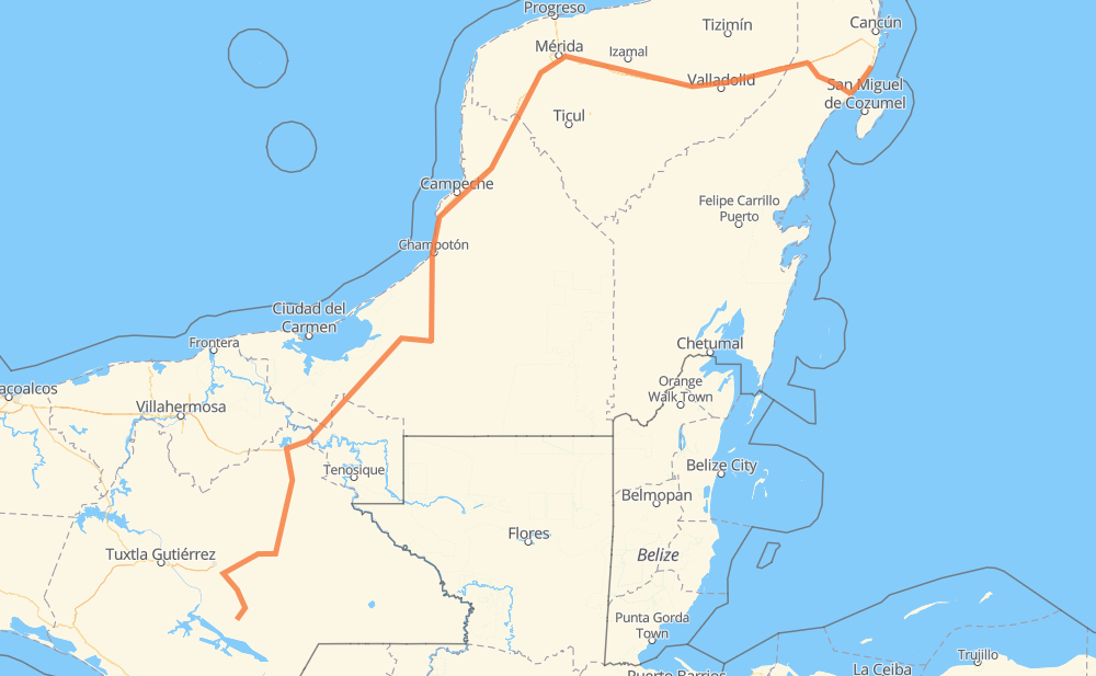
The distance from San Francisco Pujiltic to Puerto Morelos is 692 miles by road including 130 miles on motorways. Road takes approximately 12 hours and 37 minutes and goes through Mérida, Kanasín, Playa del Carmen, Las Rosas, Benito Juárez, Ocosingo and Palenque.
| Shortest distance by air | 483 mi ✈️ |
| Car route length | 691.6 mi 🚗 |
| Driving time | 12 h 37 min |
| Fuel amount | 23.5 gal |
| Fuel cost | 92.5 USD |
| Toll roads cost | 101 + ? MXN |
| Point | Distance | Time | Fuel | |
| San Francisco Pujiltic | 0 mi | 00 min | 0.0 gal | |
|
CHIS 101 MEX 190 35 mi, 42 min
|
||||
| Benito Juárez | 35 mi | 42 min | 1.0 gal | |
|
MEX 190 50 mi, 56 min
|
||||
| Ocosingo | 86 mi | 1 h 38 min | 2.6 gal | |
|
199 MEX 199 80 mi, 1 h 34 min
|
||||
| Palenque | 166 mi | 3 h 12 min | 5.6 gal | |
|
MEX 199 MEX 186 140 mi, 2 h 34 min
|
||||
| Francisco Escarcega | 306 mi | 5 h 46 min | 9.6 gal | |
|
MEX 261 47 mi, 54 min
|
||||
| Champotón | 354 mi | 6 h 41 min | 11.8 gal | |
|
MEX 180 139 mi, 2 h 32 min
|
||||
| Mérida | 492 mi | 9 h 14 min | 16.6 gal | |
|
15 mi, 17 min
|
||||
| Kanasín | 507 mi | 9 h 31 min | 16.8 gal | |
|
MEX 180 MEX 180D 166 mi, 2 h 41 min
|
||||
| Playa del Carmen | 673 mi | 12 h 13 min | 22.7 gal | |
|
MEX 307 19 mi, 23 min
|
||||
| Puerto Morelos | 692 mi | 12 h 37 min | 23.4 gal | |
Hotels of Puerto Morelos
Frequently Asked Questions
How many toll booths are there from San Francisco Pujiltic to Puerto Morelos?
There are 5 toll booths between San Francisco Pujiltic and Puerto Morelos: Usumacinta, Seybaplaya, Pisté, El Tintal and El Tintal Zona 3.
How much does the toll booths cost from San Francisco Pujiltic to Puerto Morelos?
Toll roads cost: Usumacinta (24 MXN) + Seybaplaya (77 MXN) + Pisté (?) + El Tintal (?) + El Tintal Zona 3 (?) = 101 + ? MXN
How much does it cost to drive from San Francisco Pujiltic to Puerto Morelos?
Fuel cost: 92.5 USD
This fuel cost is calculated as: (Route length 691.6 mi) / (Fuel consumption 29.4 mpg) * (Fuel price 3.93 USD / gal)
You can adjust fuel consumption and fuel price here.
Toll roads cost: 101 + ? MXN
How long is a car ride from San Francisco Pujiltic to Puerto Morelos?
Driving time: 12 h 37 min
This time is calculated for driving at the maximum permitted speed, taking into account traffic rules restrictions.
- 129 mi with a maximum speed 68 mph = 1 h 53 min
- 193 mi with a maximum speed 56 mph = 3 h 26 min
- 88 mi with a maximum speed 56 mph = 1 h 34 min
- 278 mi with a maximum speed 50 mph = 5 h 36 min
- 2 mi with a maximum speed 31 mph = 5 min
The calculated driving time does not take into account intermediate stops and traffic jams.
How far is San Francisco Pujiltic to Puerto Morelos by land?
The distance between San Francisco Pujiltic and Puerto Morelos is 691.6 mi by road including 130.5 mi on motorways.
Precise satellite coordinates of highways were used for this calculation. The start and finish points are the centers of San Francisco Pujiltic and Puerto Morelos respectively.
How far is San Francisco Pujiltic to Puerto Morelos by plane?
The shortest distance (air line, as the crow flies) between San Francisco Pujiltic and Puerto Morelos is 482.8 mi.
This distance is calculated using the Haversine formula as a great-circle distance between two points on the surface of a sphere. The start and finish points are the centers of San Francisco Pujiltic and Puerto Morelos respectively. Actual distance between airports may be different.
How many hours is San Francisco Pujiltic from Puerto Morelos by plane?
Boeing 737 airliner needs 58 min to cover the distance of 483 mi at a cruising speed of 497 mph.
Small plane "Cessna 172" needs 3 h 31 min to flight this distance at average speed of 136 mph.
This time is approximate and do not take into account takeoff and landing times, airport location and other real world factors.
How long is a helicopter ride from San Francisco Pujiltic to Puerto Morelos?
Fast helicopter "Eurocopter AS350" or "Hughes OH-6 Cayuse" need 3 h 14 min to cover the distance of 483 mi at a cruising speed of 149 mph.
Popular "Robinson R44" needs 3 h 42 min to flight this distance at average speed of 130 mph.
This time is approximate and do not take into account takeoff and landing times, aerodrome location and other real world factors.
What city is halfway between San Francisco Pujiltic and Puerto Morelos?
The halfway point between San Francisco Pujiltic and Puerto Morelos is José María Morelos y Pavón. It is located about 6 mi from the exact midpoint by road.
The distance from José María Morelos y Pavón to San Francisco Pujiltic is 339 mi and driving will take about 6 h 25 min. The road between José María Morelos y Pavón and Puerto Morelos has length 352 mi and will take approximately 6 h 12 min.
The other cities located close to halfway point:
Where is San Francisco Pujiltic in relation to Puerto Morelos?
San Francisco Pujiltic is located 483 mi south-west of Puerto Morelos.
San Francisco Pujiltic has geographic coordinates: latitude 16.2778, longitude -92.44925.
Puerto Morelos has geographic coordinates: latitude 20.84866, longitude -86.87624.
Which highway goes from San Francisco Pujiltic to Puerto Morelos?
The route from San Francisco Pujiltic to Puerto Morelos follows MEX 180, MEX 180D, MEX 186, MEX 199.
Other minor sections pass along the road:
- MEX 261: 50 mi
- MEX 305D: 27 mi
- CHIS 101: 25 mi
- 199: 17 mi
- MEX 307: 16 mi
- MEX 190: 14 mi
- 186: 1 mi