Distance between San Germán and Campo Gallo
The distance from San Germán to Campo Gallo is 958 miles by road including 15 miles on motorways. Road takes approximately 18 hours and 11 minutes and goes through Santa Rosa, Río Cuarto, Córdoba and Santiago del Estero.
| Shortest distance by air | 810 mi ✈️ |
| Car route length | 957.5 mi 🚗 |
| Driving time | 18 h 11 min |
| Fuel amount | 32.6 gal |
| Fuel cost | 128 USD |
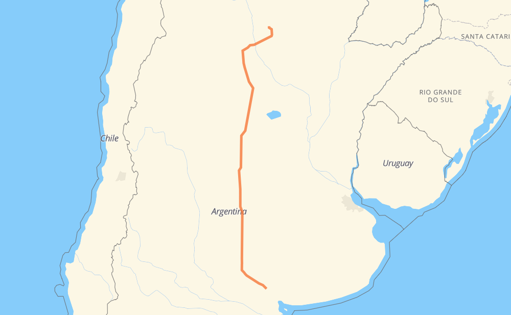
| Point | Distance | Time | Fuel | |
| San Germán | 0 mi | 00 min | 0.0 gal | |
|
RN35 145 mi, 2 h 48 min
|
||||
| La Cuesta del Sur | 145 mi | 2 h 48 min | 4.8 gal | |
|
RN35 9 mi, 10 min
|
||||
| Santa Rosa | 153 mi | 2 h 58 min | 5.1 gal | |
|
RN35 43 mi, 48 min
|
||||
| Eduardo Castex | 196 mi | 3 h 47 min | 6.2 gal | |
|
RN35 148 mi, 2 h 43 min
|
||||
| Vicuña Mackenna | 344 mi | 6 h 31 min | 10.9 gal | |
|
RN35 55 mi, 1 h 01 min
|
||||
| Río Cuarto | 399 mi | 7 h 32 min | 13.4 gal | |
|
RNA005 RN36 138 mi, 2 h 29 min
|
||||
| Córdoba | 537 mi | 10 h 02 min | 17.8 gal | |
|
RNA019 RN9 27 mi, 31 min
|
||||
| Colonia Caroya | 564 mi | 10 h 33 min | 19.0 gal | |
|
RN9 235 mi, 4 h 37 min
|
||||
| Santiago del Estero | 799 mi | 15 h 10 min | 26.8 gal | |
|
RN9 RP5 159 mi, 3 h 00 min
|
||||
| Campo Gallo | 958 mi | 18 h 11 min | 32.6 gal | |
Frequently Asked Questions
How much does it cost to drive from San Germán to Campo Gallo?
Fuel cost: 128 USD
This fuel cost is calculated as: (Route length 957.5 mi) / (Fuel consumption 29.4 mpg) * (Fuel price 3.93 USD / gal)
You can adjust fuel consumption and fuel price here.
How long is a car ride from San Germán to Campo Gallo?
Driving time: 18 h 11 min
This time is calculated for driving at the maximum permitted speed, taking into account traffic rules restrictions.
- 14 mi with a maximum speed 68 mph = 12 min
- 498 mi with a maximum speed 56 mph = 8 h 53 min
- 432 mi with a maximum speed 50 mph = 8 h 42 min
- 10 mi with a maximum speed 37 mph = 15 min
- 1 mi with a maximum speed 31 mph = 1 min
- 2 mi with a maximum speed 25 mph = 4 min
The calculated driving time does not take into account intermediate stops and traffic jams.
How far is San Germán to Campo Gallo by land?
The distance between San Germán and Campo Gallo is 957.5 mi by road including 14.9 mi on motorways.
Precise satellite coordinates of highways were used for this calculation. The start and finish points are the centers of San Germán and Campo Gallo respectively.
How far is San Germán to Campo Gallo by plane?
The shortest distance (air line, as the crow flies) between San Germán and Campo Gallo is 809.6 mi.
This distance is calculated using the Haversine formula as a great-circle distance between two points on the surface of a sphere. The start and finish points are the centers of San Germán and Campo Gallo respectively. Actual distance between airports may be different.
How many hours is San Germán from Campo Gallo by plane?
Boeing 737 airliner needs 1 h 37 min to cover the distance of 810 mi at a cruising speed of 497 mph.
Small plane "Cessna 172" needs 5 h 55 min to flight this distance at average speed of 136 mph.
This time is approximate and do not take into account takeoff and landing times, airport location and other real world factors.
How long is a helicopter ride from San Germán to Campo Gallo?
Fast helicopter "Eurocopter AS350" or "Hughes OH-6 Cayuse" need 5 h 25 min to cover the distance of 810 mi at a cruising speed of 149 mph.
Popular "Robinson R44" needs 6 h 12 min to flight this distance at average speed of 130 mph.
This time is approximate and do not take into account takeoff and landing times, aerodrome location and other real world factors.
What city is halfway between San Germán and Campo Gallo?
The halfway point between San Germán and Campo Gallo is Las Bajadas. It is located about 1 mi from the exact midpoint by road.
The distance from Las Bajadas to San Germán is 479 mi and driving will take about 8 h 59 min. The road between Las Bajadas and Campo Gallo has length 478 mi and will take approximately 9 h 11 min.
The other cities located close to halfway point:
Where is San Germán in relation to Campo Gallo?
San Germán is located 810 mi south of Campo Gallo.
San Germán has geographic coordinates: latitude -38.3, longitude -62.98333.
Campo Gallo has geographic coordinates: latitude -26.58485, longitude -62.8482.
Which highway goes from San Germán to Campo Gallo?
The route from San Germán to Campo Gallo follows RN35, RN9, RN36, RP5.
Other minor sections pass along the road:
- RP92: 36 mi
- RNA019: 14 mi
- RN2V9: 9 mi
- RNA005: 7 mi
- RN8: 5 mi