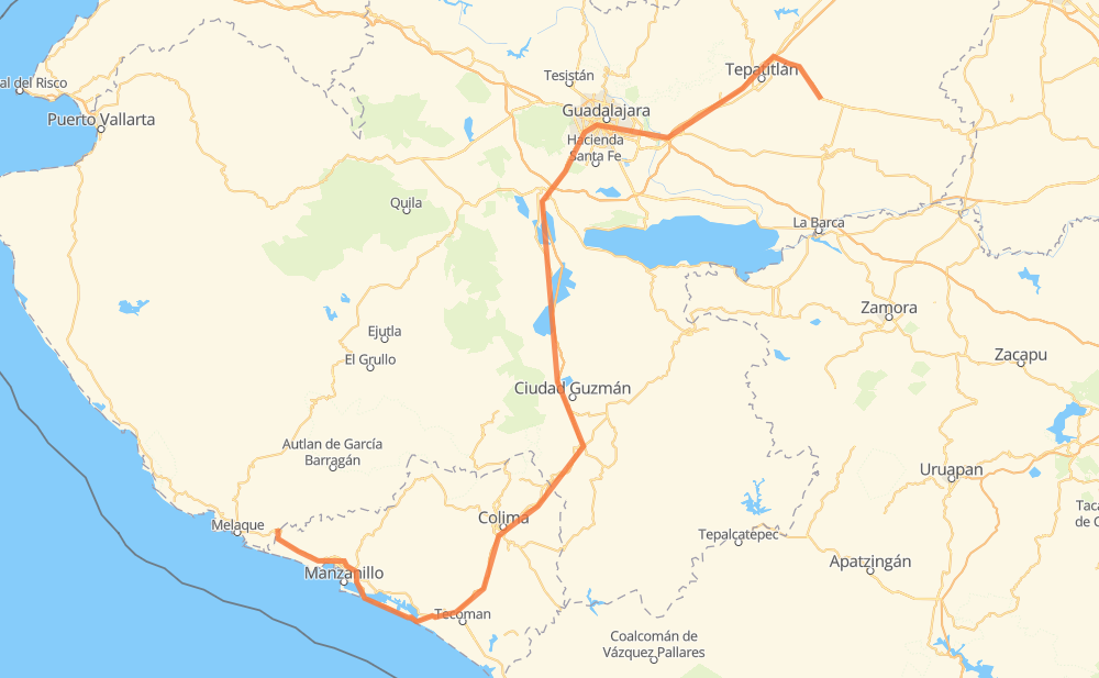
Distance between San Ignacio Cerro Gordo and Cihuatlán
The distance from San Ignacio Cerro Gordo to Cihuatlán is 271 miles by road including 224 miles on motorways. Road takes approximately 4 hours and 48 minutes and goes through Tonalá, Colima, Capilla de Guadalupe, Lomas de Santa Anita, Cuauhtémoc, Queseria and Ciudad de Armería.
| Shortest distance by air | 168 mi ✈️ |
| Car route length | 270.9 mi 🚗 |
| Driving time | 4 h 48 min |
| Fuel amount | 9.2 gal |
| Fuel cost | 36.2 USD |
| Toll roads cost | 214 + ? MXN |
| Point | Distance | Time | Fuel | |
| San Ignacio Cerro Gordo | 0 mi | 00 min | 0.0 gal | |
|
MEX 84 MEX 80D 57 mi, 1 h 00 min
|
||||
| Tonalá | 57 mi | 1 h 00 min | 1.8 gal | |
|
MEX 15D MEX 80 25 mi, 29 min
|
||||
| Lomas de Santa Anita | 82 mi | 1 h 30 min | 2.7 gal | |
|
MEX 15 5 mi, 06 min
|
||||
| Buenavista | 87 mi | 1 h 36 min | 2.9 gal | |
|
MEX 15 MEX 54D 19 mi, 19 min
|
||||
| San José de los Pozos | 106 mi | 1 h 55 min | 3.0 gal | |
|
MEX 54D 68 mi, 1 h 06 min
|
||||
| Cuauhtémoc | 175 mi | 3 h 02 min | 5.8 gal | |
|
MEX 54D 11 mi, 11 min
|
||||
| Colima | 185 mi | 3 h 13 min | 6.3 gal | |
|
MEX 54D MEX 110D 32 mi, 35 min
|
||||
| Ciudad de Armería | 217 mi | 3 h 49 min | 7.3 gal | |
|
MEX 200D 11 mi, 13 min
|
||||
| Cuyutlán | 229 mi | 4 h 02 min | 7.5 gal | |
|
MEX 200D 42 mi, 45 min
|
||||
| Cihuatlán | 271 mi | 4 h 48 min | 9.1 gal | |
Hotels of Cihuatlán
Frequently Asked Questions
How many toll booths are there from San Ignacio Cerro Gordo to Cihuatlán?
There are 4 toll booths between San Ignacio Cerro Gordo and Cihuatlán: Tepatitlan, Sayula, La Joya and Cuyutlan.
How much does the toll booths cost from San Ignacio Cerro Gordo to Cihuatlán?
Toll roads cost: Tepatitlan (214 MXN) + La Joya (?) + Sayula (?) + Cuyutlan (?) = 214 + ? MXN
How much does it cost to drive from San Ignacio Cerro Gordo to Cihuatlán?
Fuel cost: 36.2 USD
This fuel cost is calculated as: (Route length 270.9 mi) / (Fuel consumption 29.4 mpg) * (Fuel price 3.93 USD / gal)
You can adjust fuel consumption and fuel price here.
Toll roads cost: 214 + ? MXN
How long is a car ride from San Ignacio Cerro Gordo to Cihuatlán?
Driving time: 4 h 48 min
This time is calculated for driving at the maximum permitted speed, taking into account traffic rules restrictions.
- 24 mi with a maximum speed 68 mph = 21 min
- 129 mi with a maximum speed 62 mph = 2 h 3 min
- 12 mi with a maximum speed 56 mph = 13 min
- 2 mi with a maximum speed 56 mph = 2 min
- 96 mi with a maximum speed 50 mph = 1 h 55 min
- 4 mi with a maximum speed 43 mph = 6 min
- 1 mi with a maximum speed 37 mph = 1 min
- 1 mi with a maximum speed 31 mph = 2 min
- 1 mi with a maximum speed 25 mph = 1 min
The calculated driving time does not take into account intermediate stops and traffic jams.
How far is San Ignacio Cerro Gordo to Cihuatlán by land?
The distance between San Ignacio Cerro Gordo and Cihuatlán is 270.9 mi by road including 223.7 mi on motorways.
Precise satellite coordinates of highways were used for this calculation. The start and finish points are the centers of San Ignacio Cerro Gordo and Cihuatlán respectively.
How far is San Ignacio Cerro Gordo to Cihuatlán by plane?
The shortest distance (air line, as the crow flies) between San Ignacio Cerro Gordo and Cihuatlán is 167.8 mi.
This distance is calculated using the Haversine formula as a great-circle distance between two points on the surface of a sphere. The start and finish points are the centers of San Ignacio Cerro Gordo and Cihuatlán respectively. Actual distance between airports may be different.
How many hours is San Ignacio Cerro Gordo from Cihuatlán by plane?
Boeing 737 airliner needs 20 min to cover the distance of 168 mi at a cruising speed of 497 mph.
Small plane "Cessna 172" needs 1 h 13 min to flight this distance at average speed of 136 mph.
This time is approximate and do not take into account takeoff and landing times, airport location and other real world factors.
How long is a helicopter ride from San Ignacio Cerro Gordo to Cihuatlán?
Fast helicopter "Eurocopter AS350" or "Hughes OH-6 Cayuse" need 1 h 7 min to cover the distance of 168 mi at a cruising speed of 149 mph.
Popular "Robinson R44" needs 1 h 17 min to flight this distance at average speed of 130 mph.
This time is approximate and do not take into account takeoff and landing times, aerodrome location and other real world factors.
What city is halfway between San Ignacio Cerro Gordo and Cihuatlán?
The halfway point between San Ignacio Cerro Gordo and Cihuatlán is San José de los Pozos. It is located about 29 mi from the exact midpoint by road.
The distance from San José de los Pozos to San Ignacio Cerro Gordo is 106 mi and driving will take about 1 h 55 min. The road between San José de los Pozos and Cihuatlán has length 164 mi and will take approximately 2 h 52 min.
The other cities located close to halfway point:
Where is San Ignacio Cerro Gordo in relation to Cihuatlán?
San Ignacio Cerro Gordo is located 168 mi north-east of Cihuatlán.
San Ignacio Cerro Gordo has geographic coordinates: latitude 20.74333, longitude -102.53716.
Cihuatlán has geographic coordinates: latitude 19.23904, longitude -104.56185.
Which highway goes from San Ignacio Cerro Gordo to Cihuatlán?
The route from San Ignacio Cerro Gordo to Cihuatlán follows MEX 54D.
Other minor sections pass along the road:
- MEX 80D: 45 mi
- MEX 200D: 43 mi
- MEX 110D: 25 mi
- MEX 80: 22 mi
- MEX 15D: 16 mi
- MEX 15: 16 mi
- MEX 84: 16 mi
- MEX 200: 12 mi
- MEX 70: 6 mi
- MEX 90: 6 mi
- MEX 23: 3 mi
- MEX 90D: 2 mi