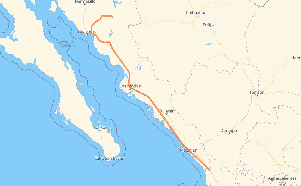
Distance between San Javier and El Tigre
The distance from San Javier to El Tigre is 643 miles by road including 503 miles on motorways. Road takes approximately 12 hours and 6 minutes and goes through Navojoa, Los Mochis, Gabriel Leyva Solano and Dimas (Estación Dimas).
| Shortest distance by air | 498 mi ✈️ |
| Car route length | 643.1 mi 🚗 |
| Driving time | 12 h 6 min |
| Fuel amount | 21.9 gal |
| Fuel cost | 85.3 USD |
| Toll roads cost | 879 + ? MXN |
| Point | Distance | Time | Fuel | |
| San Javier | 0 mi | 00 min | 0.0 gal | |
|
SON 85 134 mi, 2 h 46 min
|
||||
| Vicam | 134 mi | 2 h 46 min | 4.5 gal | |
|
MEX 15D 75 mi, 1 h 27 min
|
||||
| Navojoa | 208 mi | 4 h 13 min | 7.0 gal | |
|
MEX 15D 65 mi, 1 h 14 min
|
||||
| Gustavo Díaz Ordaz | 273 mi | 5 h 28 min | 9.2 gal | |
|
MEX 15D 8 mi, 09 min
|
||||
| Chihuahuita | 281 mi | 5 h 37 min | 9.5 gal | |
|
MEX 15D 7 mi, 09 min
|
||||
| Alfonso G. Calderon | 288 mi | 5 h 46 min | 9.6 gal | |
|
MEX 15D 19 mi, 22 min
|
||||
| Los Mochis | 307 mi | 6 h 08 min | 10.4 gal | |
|
MEX 15D 27 mi, 31 min
|
||||
| Gabriel Leyva Solano | 334 mi | 6 h 40 min | 11.1 gal | |
|
MEX 15D 180 mi, 3 h 09 min
|
||||
| Dimas (Estación Dimas) | 514 mi | 9 h 50 min | 17.2 gal | |
|
MEX 15D 129 mi, 2 h 15 min
|
||||
| El Tigre | 643 mi | 12 h 05 min | 21.8 gal | |
Frequently Asked Questions
How many toll booths are there from San Javier to El Tigre?
There are 11 toll booths between San Javier and El Tigre: Libramiento Cd Obregon, Fundicion, Estacion Don La Jaula, San Miguel, Sinaloa, Las Brisas, San Pedro km 197+100, Costa Rica, Marmol, El Rosario and El Pisal.
How much does the toll booths cost from San Javier to El Tigre?
Toll roads cost: Libramiento Cd Obregon (?) + Fundicion (90 MXN) + Estacion Don La Jaula (90 MXN) + San Miguel (69 MXN) + Sinaloa (24 MXN) + Las Brisas (76 MXN) + El Pisal (73 MXN) + San Pedro km 197+100 (34 MXN) + Costa Rica (152 MXN) + Marmol (131 MXN) + El Rosario (140 MXN) = 879 + ? MXN
How much does it cost to drive from San Javier to El Tigre?
Fuel cost: 85.3 USD
This fuel cost is calculated as: (Route length 643.1 mi) / (Fuel consumption 29.4 mpg) * (Fuel price 3.9 USD / gal)
You can adjust fuel consumption and fuel price here.
Toll roads cost: 879 + ? MXN
How long is a car ride from San Javier to El Tigre?
Driving time: 12 h 6 min
This time is calculated for driving at the maximum permitted speed, taking into account traffic rules restrictions.
- 41 mi with a maximum speed 68 mph = 36 min
- 213 mi with a maximum speed 62 mph = 3 h 25 min
- 10 mi with a maximum speed 56 mph = 10 min
- 37 mi with a maximum speed 56 mph = 39 min
- 305 mi with a maximum speed 50 mph = 6 h 8 min
- 33 mi with a maximum speed 37 mph = 53 min
- 4 mi with a maximum speed 31 mph = 6 min
- 1 mi with a maximum speed 6 mph = 6 min
The calculated driving time does not take into account intermediate stops and traffic jams.
How far is San Javier to El Tigre by land?
The distance between San Javier and El Tigre is 643.1 mi by road including 503.3 mi on motorways.
Precise satellite coordinates of highways were used for this calculation. The start and finish points are the centers of San Javier and El Tigre respectively.
How far is San Javier to El Tigre by plane?
The shortest distance (air line, as the crow flies) between San Javier and El Tigre is 498.3 mi.
This distance is calculated using the Haversine formula as a great-circle distance between two points on the surface of a sphere. The start and finish points are the centers of San Javier and El Tigre respectively. Actual distance between airports may be different.
How many hours is San Javier from El Tigre by plane?
Boeing 737 airliner needs 1 h to cover the distance of 498 mi at a cruising speed of 497 mph.
Small plane "Cessna 172" needs 3 h 38 min to flight this distance at average speed of 136 mph.
This time is approximate and do not take into account takeoff and landing times, airport location and other real world factors.
How long is a helicopter ride from San Javier to El Tigre?
Fast helicopter "Eurocopter AS350" or "Hughes OH-6 Cayuse" need 3 h 20 min to cover the distance of 498 mi at a cruising speed of 149 mph.
Popular "Robinson R44" needs 3 h 49 min to flight this distance at average speed of 130 mph.
This time is approximate and do not take into account takeoff and landing times, aerodrome location and other real world factors.
What city is halfway between San Javier and El Tigre?
The halfway point between San Javier and El Tigre is Guayparime. It is located about 1 mi from the exact midpoint by road.
The distance from Guayparime to San Javier is 321 mi and driving will take about 6 h 23 min. The road between Guayparime and El Tigre has length 322 mi and will take approximately 5 h 43 min.
The other cities located close to halfway point:
Where is San Javier in relation to El Tigre?
San Javier is located 498 mi north-west of El Tigre.
San Javier has geographic coordinates: latitude 28.59564, longitude -109.73942.
El Tigre has geographic coordinates: latitude 22.50251, longitude -105.46234.
Which highway goes from San Javier to El Tigre?
The route from San Javier to El Tigre follows MEX 15D, SON 85.
Other minor sections pass along the road:
- MEX 16: 32 mi
- SON 129: 3 mi