Distance between San Salvador el Seco and FRACC. PLAYA PALMAS
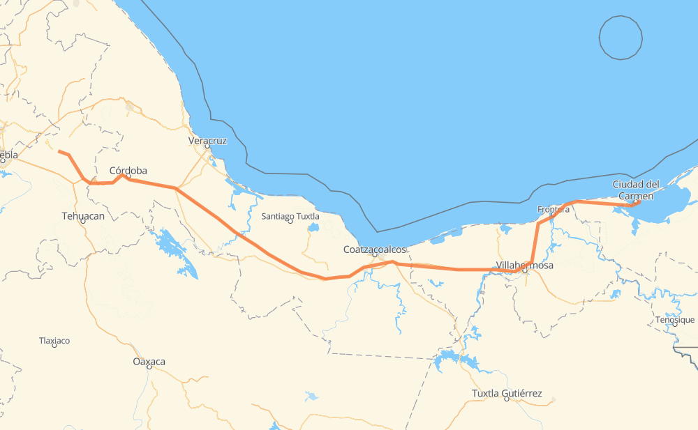
The distance from San Salvador el Seco to FRACC. PLAYA PALMAS is 472 miles by road including 285 miles on motorways. Road takes approximately 8 hours and 19 minutes and goes through Orizaba, Maltrata, Nogales, Ixtaczoquitlán, Heroica Cárdenas and Frontera.
| Shortest distance by air | 385 mi ✈️ |
| Car route length | 472.2 mi 🚗 |
| Driving time | 8 h 19 min |
| Fuel amount | 16.1 gal |
| Fuel cost | 62.6 USD |
| Toll roads cost | 702 + ? MXN |
| Point | Distance | Time | Fuel | |
| San Salvador el Seco | 0 mi | 00 min | 0.0 gal | |
|
MEX 144 4 mi, 04 min
|
||||
| Santa María Coatepec | 4 mi | 04 min | 0.1 gal | |
|
MEX 144 5 mi, 05 min
|
||||
| San Juan Atenco | 9 mi | 10 min | 0.3 gal | |
|
MEX 144 21 mi, 22 min
|
||||
| Esperanza | 30 mi | 32 min | 1.0 gal | |
|
MEX 150D 7 mi, 08 min
|
||||
| Maltrata | 37 mi | 41 min | 1.2 gal | |
|
MEX 150D 16 mi, 18 min
|
||||
| Nogales | 52 mi | 59 min | 1.7 gal | |
|
MEX 150D 4 mi, 05 min
|
||||
| Orizaba | 57 mi | 1 h 04 min | 1.8 gal | |
|
MEX 150D 3 mi, 03 min
|
||||
| Ixtaczoquitlán | 60 mi | 1 h 08 min | 2.0 gal | |
|
MEX 150D MEX 145D 267 mi, 4 h 25 min
|
||||
| Heroica Cárdenas | 327 mi | 5 h 33 min | 10.8 gal | |
|
MEX 180 86 mi, 1 h 33 min
|
||||
| Frontera | 413 mi | 7 h 07 min | 13.7 gal | |
|
MEX 180 60 mi, 1 h 11 min
|
||||
| 18.66639, -91.77704 | 472 mi | 8 h 19 min | 16.1 gal | |
Frequently Asked Questions
How many toll booths are there from San Salvador el Seco to FRACC. PLAYA PALMAS?
There are 9 toll booths between San Salvador el Seco and FRACC. PLAYA PALMAS: Fortín, Cuitláhuac, Cosamaloapan, Acayucan, Antonio Dovali, Esperanza 27, Sánchez Magallanes, Villahermosa Nacajuca and Zacatal.
How much does the toll booths cost from San Salvador el Seco to FRACC. PLAYA PALMAS?
Toll roads cost: Esperanza 27 (72 MXN) + Fortín (33 MXN) + Cuitláhuac (114 MXN) + Cosamaloapan (229 MXN) + Acayucan (?) + Antonio Dovali (20 MXN) + Sánchez Magallanes (82 MXN) + Villahermosa Nacajuca (62 MXN) + Zacatal (90 MXN) = 702 + ? MXN
How much does it cost to drive from San Salvador el Seco to FRACC. PLAYA PALMAS?
Fuel cost: 62.6 USD
This fuel cost is calculated as: (Route length 472.2 mi) / (Fuel consumption 29.4 mpg) * (Fuel price 3.9 USD / gal)
You can adjust fuel consumption and fuel price here.
Toll roads cost: 702 + ? MXN
How long is a car ride from San Salvador el Seco to FRACC. PLAYA PALMAS?
Driving time: 8 h 19 min
This time is calculated for driving at the maximum permitted speed, taking into account traffic rules restrictions.
- 38 mi with a maximum speed 68 mph = 33 min
- 191 mi with a maximum speed 62 mph = 3 h 4 min
- 74 mi with a maximum speed 56 mph = 1 h 19 min
- 16 mi with a maximum speed 56 mph = 17 min
- 152 mi with a maximum speed 50 mph = 3 h 3 min
- 1 mi with a maximum speed 31 mph = 1 min
The calculated driving time does not take into account intermediate stops and traffic jams.
How far is San Salvador el Seco to FRACC. PLAYA PALMAS by land?
The distance between San Salvador el Seco and FRACC. PLAYA PALMAS is 472.2 mi by road including 285.2 mi on motorways.
Precise satellite coordinates of highways were used for this calculation. The start and finish points are the centers of San Salvador el Seco and FRACC. PLAYA PALMAS respectively.
How far is San Salvador el Seco to FRACC. PLAYA PALMAS by plane?
The shortest distance (air line, as the crow flies) between San Salvador el Seco and FRACC. PLAYA PALMAS is 384.6 mi.
This distance is calculated using the Haversine formula as a great-circle distance between two points on the surface of a sphere. The start and finish points are the centers of San Salvador el Seco and FRACC. PLAYA PALMAS respectively. Actual distance between airports may be different.
How many hours is San Salvador el Seco from FRACC. PLAYA PALMAS by plane?
Boeing 737 airliner needs 46 min to cover the distance of 385 mi at a cruising speed of 497 mph.
Small plane "Cessna 172" needs 2 h 48 min to flight this distance at average speed of 136 mph.
This time is approximate and do not take into account takeoff and landing times, airport location and other real world factors.
How long is a helicopter ride from San Salvador el Seco to FRACC. PLAYA PALMAS?
Fast helicopter "Eurocopter AS350" or "Hughes OH-6 Cayuse" need 2 h 34 min to cover the distance of 385 mi at a cruising speed of 149 mph.
Popular "Robinson R44" needs 2 h 56 min to flight this distance at average speed of 130 mph.
This time is approximate and do not take into account takeoff and landing times, aerodrome location and other real world factors.
What city is halfway between San Salvador el Seco and FRACC. PLAYA PALMAS?
The halfway point between San Salvador el Seco and FRACC. PLAYA PALMAS is San Pedro Mártir. It is located about 5 mi from the exact midpoint by road.
The distance from San Pedro Mártir to San Salvador el Seco is 241 mi and driving will take about 4 h 3 min. The road between San Pedro Mártir and FRACC. PLAYA PALMAS has length 231 mi and will take approximately 4 h 16 min.
The other cities located close to halfway point:
Where is San Salvador el Seco in relation to FRACC. PLAYA PALMAS?
San Salvador el Seco is located 385 mi west of FRACC. PLAYA PALMAS.
San Salvador el Seco has geographic coordinates: latitude 19.13465, longitude -97.64181.
FRACC. PLAYA PALMAS has geographic coordinates: latitude 18.66639, longitude -91.77704.
Which highway goes from San Salvador el Seco to FRACC. PLAYA PALMAS?
The route from San Salvador el Seco to FRACC. PLAYA PALMAS follows MEX 180, MEX 145D, MEX 150D.
Other minor sections pass along the road:
- MEX 180D: 54 mi
- MEX 144: 29 mi