Distance between San Salvador el Seco and Ixtlan del Río
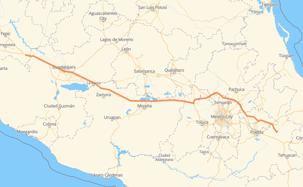
The distance from San Salvador el Seco to Ixtlan del Río is 520 miles by road including 446 miles on motorways. Road takes approximately 9 hours and 10 minutes and goes through Tonalá, Jilotepec de Molina Enriquez, Pastores, Huaniqueo de Morales, Panindicuaro, Ecuandureo and Vista Hermosa de Negrete.
| Shortest distance by air | 456 mi ✈️ |
| Car route length | 520.1 mi 🚗 |
| Driving time | 9 h 10 min |
| Fuel amount | 17.7 gal |
| Fuel cost | 69.5 USD |
| Toll roads cost | 874 + ? MXN |
| Point | Distance | Time | Fuel | |
| San Salvador el Seco | 0 mi | 00 min | 0.0 gal | |
|
MEX 140 MEX M40D 163 mi, 2 h 51 min
|
||||
| Jilotepec de Molina Enriquez | 163 mi | 2 h 51 min | 5.4 gal | |
|
MEX M40D MEX 15D 142 mi, 2 h 24 min
|
||||
| Huaniqueo de Morales | 305 mi | 5 h 15 min | 10.3 gal | |
|
MEX 15D 19 mi, 19 min
|
||||
| Panindicuaro | 324 mi | 5 h 35 min | 10.9 gal | |
|
MEX 15D 33 mi, 36 min
|
||||
| Ecuandureo | 357 mi | 6 h 11 min | 12.1 gal | |
|
MEX 15D 17 mi, 18 min
|
||||
| Vista Hermosa de Negrete | 374 mi | 6 h 29 min | 12.6 gal | |
|
MEX 15D 58 mi, 1 h 09 min
|
||||
| Tonalá | 433 mi | 7 h 39 min | 14.6 gal | |
|
MEX 15D 24 mi, 28 min
|
||||
| Campestre Agronomia | 456 mi | 8 h 07 min | 15.4 gal | |
|
MEX 15D 14 mi, 13 min
|
||||
| El Arenal | 470 mi | 8 h 20 min | 15.7 gal | |
|
MEX 15D 50 mi, 49 min
|
||||
| Ixtlan del Río | 520 mi | 9 h 10 min | 17.7 gal | |
Frequently Asked Questions
How many toll booths are there from San Salvador el Seco to Ixtlan del Río?
There are 11 toll booths between San Salvador el Seco and Ixtlan del Río: Plan de Barrancas, La Joya, Ocotlán, Zinapecuaro, Contepec, Panindicuaro, Ecuandureo, Sanctorum, Atlacomulco — Maravatio, Atlacomulco 2 and Arenal.
How much does the toll booths cost from San Salvador el Seco to Ixtlan del Río?
Toll roads cost: Sanctorum (?) + Atlacomulco 2 (?) + Atlacomulco — Maravatio (50 MXN) + Contepec (?) + Zinapecuaro (161 MXN) + Panindicuaro (?) + Ecuandureo (111 MXN) + Ocotlán (226 MXN) + La Joya (?) + Arenal (131 MXN) + Plan de Barrancas (195 MXN) = 874 + ? MXN
How much does it cost to drive from San Salvador el Seco to Ixtlan del Río?
Fuel cost: 69.5 USD
This fuel cost is calculated as: (Route length 520.1 mi) / (Fuel consumption 29.4 mpg) * (Fuel price 3.93 USD / gal)
You can adjust fuel consumption and fuel price here.
Toll roads cost: 874 + ? MXN
How long is a car ride from San Salvador el Seco to Ixtlan del Río?
Driving time: 9 h 10 min
This time is calculated for driving at the maximum permitted speed, taking into account traffic rules restrictions.
- 47 mi with a maximum speed 68 mph = 41 min
- 227 mi with a maximum speed 62 mph = 3 h 39 min
- 69 mi with a maximum speed 56 mph = 1 h 14 min
- 174 mi with a maximum speed 50 mph = 3 h 30 min
- 2 mi with a maximum speed 37 mph = 4 min
- 1 mi with a maximum speed 31 mph = 1 min
The calculated driving time does not take into account intermediate stops and traffic jams.
How far is San Salvador el Seco to Ixtlan del Río by land?
The distance between San Salvador el Seco and Ixtlan del Río is 520.1 mi by road including 445.5 mi on motorways.
Precise satellite coordinates of highways were used for this calculation. The start and finish points are the centers of San Salvador el Seco and Ixtlan del Río respectively.
How far is San Salvador el Seco to Ixtlan del Río by plane?
The shortest distance (air line, as the crow flies) between San Salvador el Seco and Ixtlan del Río is 456.1 mi.
This distance is calculated using the Haversine formula as a great-circle distance between two points on the surface of a sphere. The start and finish points are the centers of San Salvador el Seco and Ixtlan del Río respectively. Actual distance between airports may be different.
How many hours is San Salvador el Seco from Ixtlan del Río by plane?
Boeing 737 airliner needs 55 min to cover the distance of 456 mi at a cruising speed of 497 mph.
Small plane "Cessna 172" needs 3 h 20 min to flight this distance at average speed of 136 mph.
This time is approximate and do not take into account takeoff and landing times, airport location and other real world factors.
How long is a helicopter ride from San Salvador el Seco to Ixtlan del Río?
Fast helicopter "Eurocopter AS350" or "Hughes OH-6 Cayuse" need 3 h 3 min to cover the distance of 456 mi at a cruising speed of 149 mph.
Popular "Robinson R44" needs 3 h 29 min to flight this distance at average speed of 130 mph.
This time is approximate and do not take into account takeoff and landing times, aerodrome location and other real world factors.
What city is halfway between San Salvador el Seco and Ixtlan del Río?
The halfway point between San Salvador el Seco and Ixtlan del Río is Santa Rita. It is located about 27 mi from the exact midpoint by road.
The distance from Santa Rita to San Salvador el Seco is 288 mi and driving will take about 4 h 56 min. The road between Santa Rita and Ixtlan del Río has length 233 mi and will take approximately 4 h 14 min.
The other cities located close to halfway point:
Where is San Salvador el Seco in relation to Ixtlan del Río?
San Salvador el Seco is located 456 mi south-east of Ixtlan del Río.
San Salvador el Seco has geographic coordinates: latitude 19.13465, longitude -97.64181.
Ixtlan del Río has geographic coordinates: latitude 21.03586, longitude -104.36988.
Which highway goes from San Salvador el Seco to Ixtlan del Río?
The route from San Salvador el Seco to Ixtlan del Río follows MEX 15D, MEX M40D.
Other minor sections pass along the road:
- MEX 136: 52 mi
- MEX 70: 21 mi
- MEX 90: 21 mi
- MEX 80D: 11 mi
- MEX 80: 7 mi
- MEX 23: 5 mi
- MEX 040D: 4 mi
- MEX 140: 2 mi