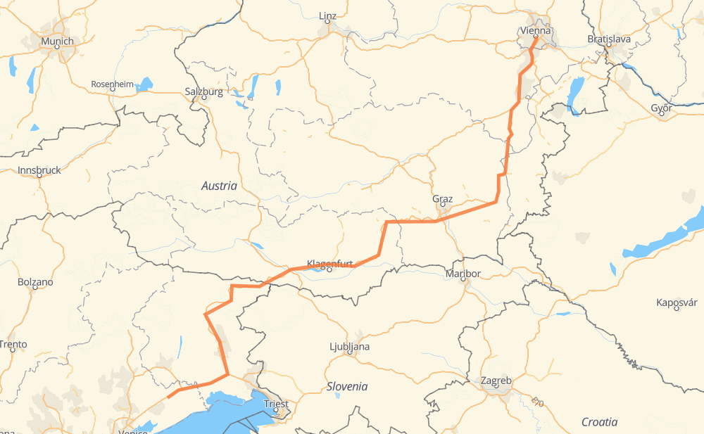
The distance from San Stino di Livenza to Vienna is 342 miles by road including 336 miles on motorways. Road takes approximately 5 hours and 21 minutes and goes through Udine, Graz, Portogruaro, San Michele al Tagliamento, Klemaun, Villach and Velden am Wörther See.
You can adjust fuel consumption and fuel price here.
How long is a car ride from San Stino di Livenza to Vienna?
Driving time:
5 h 21 min
This time is calculated for driving at the maximum permitted speed, taking into account traffic rules restrictions.
250 mi with a maximum speed 68 mph = 3 h 40 min
57 mi with a maximum speed 62 mph = 55 min
27 mi with a maximum speed 50 mph = 33 min
1 mi with a maximum speed 43 mph = 2 min
4 mi with a maximum speed 31 mph = 8 min
1 mi with a maximum speed 19 mph = 1 min
The calculated driving time does not take into account intermediate stops and traffic jams.
How far is San Stino di Livenza to Vienna by land?
The distance between San Stino di Livenza and Vienna is 341.8 mi by road including 335.5 mi on motorways.
Precise satellite coordinates of highways were used for this calculation. The start and finish points are the centers of San Stino di Livenza and Vienna respectively.
How far is San Stino di Livenza to Vienna by plane?
The shortest distance (air line, as the crow flies) between San Stino di Livenza and Vienna is 244.2 mi.
This distance is calculated using the Haversine formula as a great-circle distance between two points on the surface of a sphere. The start and finish points are the centers of San Stino di Livenza and Vienna respectively. Actual distance between airports may be different.
How many hours is San Stino di Livenza from Vienna by plane?
Boeing 737 airliner needs 29 min to cover the distance of 244 mi at a cruising speed of 497 mph.
Small plane "Cessna 172" needs 1 h 47 min to flight this distance at average speed of 136 mph.
This time is approximate and do not take into account takeoff and landing times, airport location and other real world factors.
How long is a helicopter ride from San Stino di Livenza to Vienna?
Fast helicopter "Eurocopter AS350" or "Hughes OH-6 Cayuse" need 1 h 38 min to cover the distance of 244 mi at a cruising speed of 149 mph.
Popular "Robinson R44" needs 1 h 52 min to flight this distance at average speed of 130 mph.
This time is approximate and do not take into account takeoff and landing times, aerodrome location and other real world factors.
What city is halfway between San Stino di Livenza and Vienna?
The halfway point between San Stino di Livenza and Vienna is Gönitz. It is located about 1 mi from the exact midpoint by road.
The distance from Gönitz to San Stino di Livenza is 170 mi and driving will take about 2 h 36 min. The road between Gönitz and Vienna has length 171 mi and will take approximately 2 h 45 min.
The other cities located close to halfway point:
Sankt Andrä is in 173 mi from San Stino di Livenza and 168 mi from Vienna
Wallersberg is in 166 mi from San Stino di Livenza and 175 mi from Vienna
Sankt Jakob is in 164 mi from San Stino di Livenza and 177 mi from Vienna
Where is San Stino di Livenza in relation to Vienna?
San Stino di Livenza is located 244 mi south-west of Vienna.
San Stino di Livenza has geographic coordinates: latitude 45.7314, longitude 12.68053.
Vienna has geographic coordinates: latitude 48.20835, longitude 16.37249.
Which highway goes from San Stino di Livenza to Vienna?
The route from San Stino di Livenza to Vienna follows A2, A23.