Distance between Santa Helena and Malacacheta
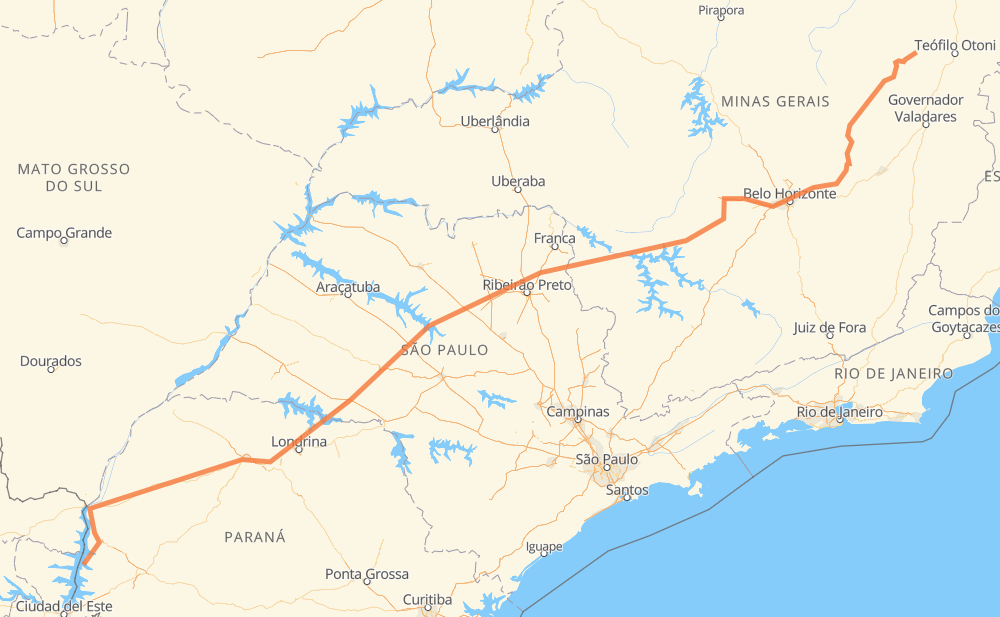
The distance from Santa Helena to Malacacheta is 1,182 miles by road including 185 miles on motorways. Road takes approximately 22 hours and 9 minutes and goes through Assis, Betim, Itabira, Tarumã, Parque das Oliveiras, Condomínio Balneário Recreativa and Itaú de Minas.
| Shortest distance by air | 925 mi ✈️ |
| Car route length | 1,181.8 mi 🚗 |
| Driving time | 22 h 9 min |
| Fuel amount | 40.2 gal |
| Fuel cost | 158 USD |
| Point | Distance | Time | Fuel | |
| -24.85917, -54.33288 | 0 mi | 00 min | 0.0 gal | |
|
PR-323 355 mi, 6 h 39 min
|
||||
| Tarumã | 355 mi | 6 h 39 min | 24.0 gal | |
|
SP-333 18 mi, 21 min
|
||||
| Assis | 373 mi | 7 h 01 min | 24.2 gal | |
|
SP-333 206 mi, 3 h 39 min
|
||||
| Parque das Oliveiras | 579 mi | 10 h 40 min | 31.7 gal | |
|
SP-328 3 mi, 02 min
|
||||
| Condomínio Balneário Recreativa | 582 mi | 10 h 43 min | 31.8 gal | |
|
SP-330 BR-265 92 mi, 1 h 37 min
|
||||
| Itaú de Minas | 674 mi | 12 h 20 min | 34.8 gal | |
|
MG-050 27 mi, 29 min
|
||||
| Cancã | 701 mi | 12 h 50 min | 35.8 gal | |
|
MG-050 36 mi, 39 min
|
||||
| Piumhi | 737 mi | 13 h 29 min | 37.0 gal | |
|
MG-050 158 mi, 2 h 44 min
|
||||
| Betim | 895 mi | 16 h 14 min | 42.3 gal | |
|
BR-262 BR-381 85 mi, 2 h 01 min
|
||||
| Itabira | 979 mi | 18 h 15 min | 45.2 gal | |
|
MG-462 BR-120 203 mi, 3 h 52 min
|
||||
| Malacacheta | 1,182 mi | 22 h 08 min | 52.1 gal | |
Frequently Asked Questions
How much does it cost to drive from Santa Helena to Malacacheta?
Fuel cost: 158 USD
This fuel cost is calculated as: (Route length 1,181.8 mi) / (Fuel consumption 29.4 mpg) * (Fuel price 3.93 USD / gal)
You can adjust fuel consumption and fuel price here.
How long is a car ride from Santa Helena to Malacacheta?
Driving time: 22 h 9 min
This time is calculated for driving at the maximum permitted speed, taking into account traffic rules restrictions.
- 117 mi with a maximum speed 68 mph = 1 h 43 min
- 19 mi with a maximum speed 62 mph = 18 min
- 723 mi with a maximum speed 56 mph = 12 h 54 min
- 245 mi with a maximum speed 50 mph = 4 h 56 min
- 8 mi with a maximum speed 43 mph = 10 min
- 42 mi with a maximum speed 37 mph = 1 h 7 min
- 17 mi with a maximum speed 31 mph = 32 min
- 10 mi with a maximum speed 25 mph = 24 min
The calculated driving time does not take into account intermediate stops and traffic jams.
How far is Santa Helena to Malacacheta by land?
The distance between Santa Helena and Malacacheta is 1,181.8 mi by road including 184.5 mi on motorways.
Precise satellite coordinates of highways were used for this calculation. The start and finish points are the centers of Santa Helena and Malacacheta respectively.
How far is Santa Helena to Malacacheta by plane?
The shortest distance (air line, as the crow flies) between Santa Helena and Malacacheta is 925.2 mi.
This distance is calculated using the Haversine formula as a great-circle distance between two points on the surface of a sphere. The start and finish points are the centers of Santa Helena and Malacacheta respectively. Actual distance between airports may be different.
How many hours is Santa Helena from Malacacheta by plane?
Boeing 737 airliner needs 1 h 51 min to cover the distance of 925 mi at a cruising speed of 497 mph.
Small plane "Cessna 172" needs 6 h 46 min to flight this distance at average speed of 136 mph.
This time is approximate and do not take into account takeoff and landing times, airport location and other real world factors.
How long is a helicopter ride from Santa Helena to Malacacheta?
Fast helicopter "Eurocopter AS350" or "Hughes OH-6 Cayuse" need 6 h 12 min to cover the distance of 925 mi at a cruising speed of 149 mph.
Popular "Robinson R44" needs 7 h 5 min to flight this distance at average speed of 130 mph.
This time is approximate and do not take into account takeoff and landing times, aerodrome location and other real world factors.
What city is halfway between Santa Helena and Malacacheta?
The halfway point between Santa Helena and Malacacheta is Condomínio Balneário Recreativa. It is located about 9 mi from the exact midpoint by road.
The distance from Condomínio Balneário Recreativa to Santa Helena is 582 mi and driving will take about 10 h 43 min. The road between Condomínio Balneário Recreativa and Malacacheta has length 600 mi and will take approximately 11 h 25 min.
The other cities located close to halfway point:
Where is Santa Helena in relation to Malacacheta?
Santa Helena is located 925 mi south-west of Malacacheta.
Santa Helena has geographic coordinates: latitude -24.85917, longitude -54.33288.
Malacacheta has geographic coordinates: latitude -17.84307, longitude -42.07778.
Which highway goes from Santa Helena to Malacacheta?
The route from Santa Helena to Malacacheta follows SP-333, MG-050, PR-323, BR-120, MGC-120, BR-262.
Other minor sections pass along the road:
- BR-381: 55 mi
- BR-265: 46 mi
- BR-272: 34 mi
- BR-163: 32 mi
- SP-351: 32 mi
- MG-217: 31 mi
- PR-495: 25 mi
- PR-444: 24 mi
- BR-494: 21 mi
- SP-334: 18 mi
- BR-376: 13 mi
- MG-434: 12 mi
- PR-317: 9 mi
- PR-445: 9 mi
- SP-328: 8 mi
- BR-369: 8 mi
- MG-462: 7 mi
- BR-467: 7 mi
- PRC-467: 7 mi
- PR-986: 6 mi
- AMG-1210: 6 mi
- SP-322: 6 mi
- BR-153: 4 mi
- MG-129: 3 mi
- MG-170: 2 mi
- BR-374: 2 mi
- SP-270: 2 mi
- BR-040: 2 mi
- SP-330: 1 mi
- BR-050: 1 mi
- SPA 348/334: 1 mi
- SP-294: 1 mi