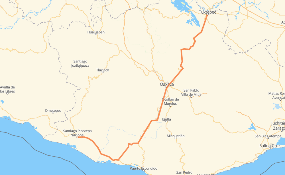
Distance between Santiago Pinotepa Nacional and San Juan Bautista Tuxtepec
The distance from Santiago Pinotepa Nacional to San Juan Bautista Tuxtepec is 341 miles by road. Road takes approximately 7 hours and 3 minutes and goes through Oaxaca, Zimatlán de Álvarez, Villa de Zaachila and Santa Cruz Xoxocotlán.
| Shortest distance by air | 175 mi ✈️ |
| Car route length | 340.5 mi 🚗 |
| Driving time | 7 h 3 min |
| Fuel amount | 11.6 gal |
| Fuel cost | 45.5 USD |
| Point | Distance | Time | Fuel | |
| Santiago Pinotepa Nacional | 0 mi | 00 min | 0.0 gal | |
|
MEX 200 15 mi, 17 min
|
||||
| Santiago Jamiltepec | 15 mi | 17 min | 0.2 gal | |
|
MEX 200 23 mi, 27 min
|
||||
| San José del Progreso | 38 mi | 45 min | 1.1 gal | |
|
MEX 200 37 mi, 41 min
|
||||
| Santa Catarina Juquila | 75 mi | 1 h 27 min | 2.2 gal | |
|
22 mi, 25 min
|
||||
| Santa María Yolotepec | 97 mi | 1 h 53 min | 3.1 gal | |
|
MEX 131 104 mi, 2 h 04 min
|
||||
| Zimatlán de Álvarez | 201 mi | 3 h 57 min | 6.8 gal | |
|
MEX 131 7 mi, 07 min
|
||||
| Villa de Zaachila | 208 mi | 4 h 05 min | 7.0 gal | |
|
6 mi, 08 min
|
||||
| Santa Cruz Xoxocotlán | 214 mi | 4 h 14 min | 7.3 gal | |
|
2 mi, 03 min
|
||||
| Oaxaca | 216 mi | 4 h 17 min | 7.3 gal | |
|
MEX 190 MEX 175 137 mi, 2 h 45 min
|
||||
| San Juan Bautista Tuxtepec | 354 mi | 7 h 03 min | 11.9 gal | |
Hotels of San Juan Bautista Tuxtepec
Frequently Asked Questions
How much does it cost to drive from Santiago Pinotepa Nacional to San Juan Bautista Tuxtepec?
Fuel cost: 45.5 USD
This fuel cost is calculated as: (Route length 340.5 mi) / (Fuel consumption 29.4 mpg) * (Fuel price 3.93 USD / gal)
You can adjust fuel consumption and fuel price here.
How long is a car ride from Santiago Pinotepa Nacional to San Juan Bautista Tuxtepec?
Driving time: 7 h 3 min
This time is calculated for driving at the maximum permitted speed, taking into account traffic rules restrictions.
- 58 mi with a maximum speed 56 mph = 1 h 2 min
- 25 mi with a maximum speed 56 mph = 26 min
- 258 mi with a maximum speed 50 mph = 5 h 11 min
- 7 mi with a maximum speed 37 mph = 11 min
- 2 mi with a maximum speed 31 mph = 4 min
- 3 mi with a maximum speed 25 mph = 7 min
The calculated driving time does not take into account intermediate stops and traffic jams.
How far is Santiago Pinotepa Nacional to San Juan Bautista Tuxtepec by land?
The distance between Santiago Pinotepa Nacional and San Juan Bautista Tuxtepec is 340.5 mi by road.
Precise satellite coordinates of highways were used for this calculation. The start and finish points are the centers of Santiago Pinotepa Nacional and San Juan Bautista Tuxtepec respectively.
How far is Santiago Pinotepa Nacional to San Juan Bautista Tuxtepec by plane?
The shortest distance (air line, as the crow flies) between Santiago Pinotepa Nacional and San Juan Bautista Tuxtepec is 175.2 mi.
This distance is calculated using the Haversine formula as a great-circle distance between two points on the surface of a sphere. The start and finish points are the centers of Santiago Pinotepa Nacional and San Juan Bautista Tuxtepec respectively. Actual distance between airports may be different.
How many hours is Santiago Pinotepa Nacional from San Juan Bautista Tuxtepec by plane?
Boeing 737 airliner needs 21 min to cover the distance of 175 mi at a cruising speed of 497 mph.
Small plane "Cessna 172" needs 1 h 16 min to flight this distance at average speed of 136 mph.
This time is approximate and do not take into account takeoff and landing times, airport location and other real world factors.
How long is a helicopter ride from Santiago Pinotepa Nacional to San Juan Bautista Tuxtepec?
Fast helicopter "Eurocopter AS350" or "Hughes OH-6 Cayuse" need 1 h 10 min to cover the distance of 175 mi at a cruising speed of 149 mph.
Popular "Robinson R44" needs 1 h 20 min to flight this distance at average speed of 130 mph.
This time is approximate and do not take into account takeoff and landing times, aerodrome location and other real world factors.
What city is halfway between Santiago Pinotepa Nacional and San Juan Bautista Tuxtepec?
The halfway point between Santiago Pinotepa Nacional and San Juan Bautista Tuxtepec is El Vado. It is located about 6 mi from the exact midpoint by road.
The distance from El Vado to Santiago Pinotepa Nacional is 176 mi and driving will take about 3 h 27 min. The road between El Vado and San Juan Bautista Tuxtepec has length 165 mi and will take approximately 3 h 35 min.
The other cities located close to halfway point:
- Villa Sola de Vega is in 163 mi from Santiago Pinotepa Nacional and 177 mi from San Juan Bautista Tuxtepec
- Ayoquezco de Aldama is in 183 mi from Santiago Pinotepa Nacional and 157 mi from San Juan Bautista Tuxtepec
- Santos Reyes Sola is in 156 mi from Santiago Pinotepa Nacional and 185 mi from San Juan Bautista Tuxtepec
Where is Santiago Pinotepa Nacional in relation to San Juan Bautista Tuxtepec?
Santiago Pinotepa Nacional is located 175 mi south-west of San Juan Bautista Tuxtepec.
Santiago Pinotepa Nacional has geographic coordinates: latitude 16.33805, longitude -98.05028.
San Juan Bautista Tuxtepec has geographic coordinates: latitude 18.08611, longitude -96.12389.
Which highway goes from Santiago Pinotepa Nacional to San Juan Bautista Tuxtepec?
The route from Santiago Pinotepa Nacional to San Juan Bautista Tuxtepec follows MEX 175, MEX 131.
Other minor sections pass along the road:
- MEX 200: 56 mi
- MEX 190: 2 mi