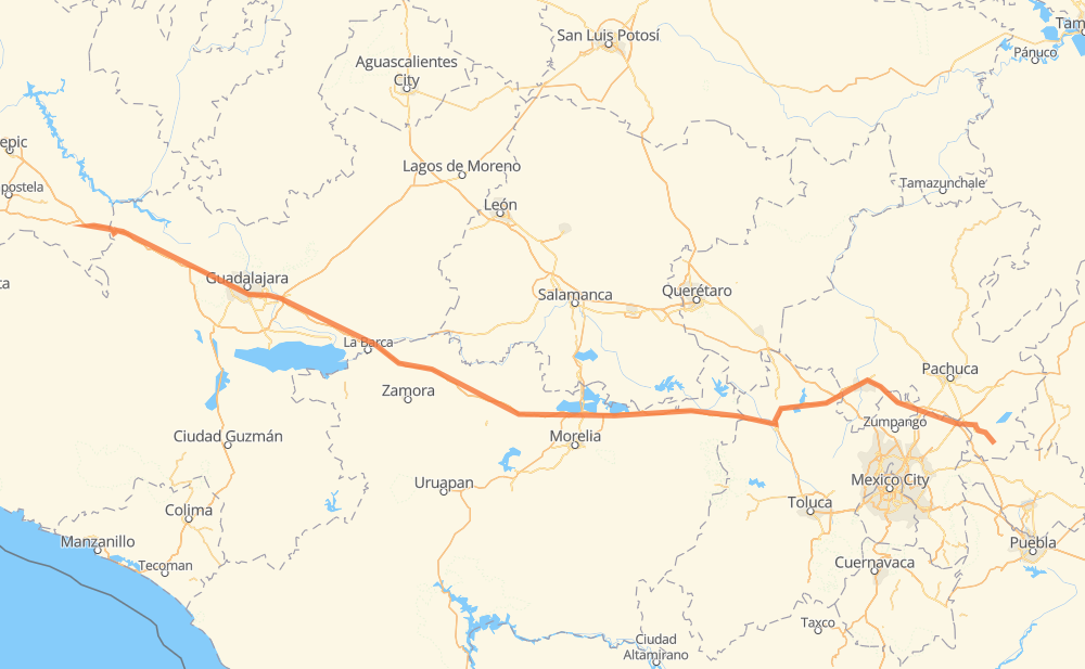
Distance between Santo Tomás and Apan
The distance from Santo Tomás to Apan is 462 miles by road including 440 miles on motorways. Road takes approximately 8 hours and 7 minutes and goes through Tonalá, El Arenal, Campestre Agronomia, Vista Hermosa de Negrete, Ecuandureo, Panindicuaro and Huaniqueo de Morales.
| Shortest distance by air | 378 mi ✈️ |
| Car route length | 462.3 mi 🚗 |
| Driving time | 8 h 7 min |
| Fuel amount | 15.7 gal |
| Fuel cost | 61.8 USD |
| Toll roads cost | 874 + ? MXN |
| Point | Distance | Time | Fuel | |
| Santo Tomás | 0 mi | 00 min | 0.0 gal | |
|
MEX 15D 69 mi, 1 h 08 min
|
||||
| El Arenal | 69 mi | 1 h 08 min | 2.0 gal | |
|
MEX 15D 14 mi, 13 min
|
||||
| Campestre Agronomia | 83 mi | 1 h 21 min | 2.8 gal | |
|
MEX 15D 23 mi, 28 min
|
||||
| Tonalá | 106 mi | 1 h 49 min | 3.5 gal | |
|
MEX 15D 58 mi, 1 h 09 min
|
||||
| Vista Hermosa de Negrete | 165 mi | 2 h 59 min | 5.5 gal | |
|
MEX 15D 17 mi, 18 min
|
||||
| Ecuandureo | 182 mi | 3 h 17 min | 6.1 gal | |
|
MEX 15D 33 mi, 36 min
|
||||
| Panindicuaro | 215 mi | 3 h 53 min | 7.2 gal | |
|
MEX 15D 19 mi, 19 min
|
||||
| Huaniqueo de Morales | 234 mi | 4 h 13 min | 7.9 gal | |
|
MEX 15D 70 mi, 1 h 08 min
|
||||
| Maravatio | 304 mi | 5 h 21 min | 10.2 gal | |
|
MEX 15D MEX M40D 158 mi, 2 h 46 min
|
||||
| Apan | 462 mi | 8 h 07 min | 15.7 gal | |
Frequently Asked Questions
How many toll booths are there from Santo Tomás to Apan?
There are 11 toll booths between Santo Tomás and Apan: Plan de Barrancas, La Joya, Ocotlán, Zinapecuaro, Contepec, Panindicuaro, Ecuandureo, Tulancingo, Atlacomulco — Maravatio, Atlacomulco 2 and Arenal.
How much does the toll booths cost from Santo Tomás to Apan?
Toll roads cost: Plan de Barrancas (195 MXN) + Arenal (131 MXN) + La Joya (?) + Ocotlán (226 MXN) + Ecuandureo (111 MXN) + Panindicuaro (?) + Zinapecuaro (161 MXN) + Contepec (?) + Atlacomulco — Maravatio (50 MXN) + Atlacomulco 2 (?) + Tulancingo (?) = 874 + ? MXN
How much does it cost to drive from Santo Tomás to Apan?
Fuel cost: 61.8 USD
This fuel cost is calculated as: (Route length 462.3 mi) / (Fuel consumption 29.4 mpg) * (Fuel price 3.93 USD / gal)
You can adjust fuel consumption and fuel price here.
Toll roads cost: 874 + ? MXN
How long is a car ride from Santo Tomás to Apan?
Driving time: 8 h 7 min
This time is calculated for driving at the maximum permitted speed, taking into account traffic rules restrictions.
- 54 mi with a maximum speed 68 mph = 47 min
- 222 mi with a maximum speed 62 mph = 3 h 34 min
- 4 mi with a maximum speed 56 mph = 3 min
- 178 mi with a maximum speed 50 mph = 3 h 35 min
- 2 mi with a maximum speed 37 mph = 4 min
- 1 mi with a maximum speed 31 mph = 1 min
The calculated driving time does not take into account intermediate stops and traffic jams.
How far is Santo Tomás to Apan by land?
The distance between Santo Tomás and Apan is 462.3 mi by road including 439.9 mi on motorways.
Precise satellite coordinates of highways were used for this calculation. The start and finish points are the centers of Santo Tomás and Apan respectively.
How far is Santo Tomás to Apan by plane?
The shortest distance (air line, as the crow flies) between Santo Tomás and Apan is 377.8 mi.
This distance is calculated using the Haversine formula as a great-circle distance between two points on the surface of a sphere. The start and finish points are the centers of Santo Tomás and Apan respectively. Actual distance between airports may be different.
How many hours is Santo Tomás from Apan by plane?
Boeing 737 airliner needs 45 min to cover the distance of 378 mi at a cruising speed of 497 mph.
Small plane "Cessna 172" needs 2 h 45 min to flight this distance at average speed of 136 mph.
This time is approximate and do not take into account takeoff and landing times, airport location and other real world factors.
How long is a helicopter ride from Santo Tomás to Apan?
Fast helicopter "Eurocopter AS350" or "Hughes OH-6 Cayuse" need 2 h 32 min to cover the distance of 378 mi at a cruising speed of 149 mph.
Popular "Robinson R44" needs 2 h 53 min to flight this distance at average speed of 130 mph.
This time is approximate and do not take into account takeoff and landing times, aerodrome location and other real world factors.
What city is halfway between Santo Tomás and Apan?
The halfway point between Santo Tomás and Apan is Huaniqueo de Morales. It is located about 3 mi from the exact midpoint by road.
The distance from Huaniqueo de Morales to Santo Tomás is 234 mi and driving will take about 4 h 13 min. The road between Huaniqueo de Morales and Apan has length 228 mi and will take approximately 3 h 54 min.
The other cities located close to halfway point:
Where is Santo Tomás in relation to Apan?
Santo Tomás is located 378 mi west of Apan.
Santo Tomás has geographic coordinates: latitude 20.99549, longitude -104.11537.
Apan has geographic coordinates: latitude 19.70944, longitude -98.45.
Which highway goes from Santo Tomás to Apan?
The route from Santo Tomás to Apan follows MEX 15D, MEX M40D.
Other minor sections pass along the road:
- MEX 70: 19 mi
- MEX 90: 19 mi
- MEX 80D: 11 mi
- 115: 9 mi
- MEX 80: 7 mi
- MEX 23: 5 mi
- MEX 040D: 4 mi
- MEX 132: 1 mi