Distance between Santo Tomás and El Porvenir (El Porvenir Cumuripa)
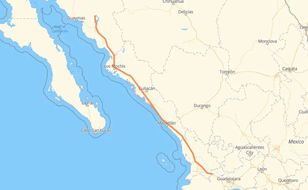
The distance from Santo Tomás to El Porvenir (El Porvenir Cumuripa) is 681 miles by road including 603 miles on motorways. Road takes approximately 12 hours and 23 minutes and goes through Tepic, Dimas (Estación Dimas), Gabriel Leyva Solano, Los Mochis and Navojoa.
| Shortest distance by air | 611 mi ✈️ |
| Car route length | 681 mi 🚗 |
| Driving time | 12 h 23 min |
| Fuel amount | 23.2 gal |
| Fuel cost | 91 USD |
| Toll roads cost | 1,404 + ? MXN |
| Point | Distance | Time | Fuel | |
| Santo Tomás | 0 mi | 00 min | 0.0 gal | |
|
MEX 15D 71 mi, 1 h 08 min
|
||||
| Tepic | 71 mi | 1 h 08 min | 2.3 gal | |
|
MEX 15D 124 mi, 1 h 59 min
|
||||
| El Rosario | 195 mi | 3 h 08 min | 6.5 gal | |
|
MEX 15D 7 mi, 06 min
|
||||
| Otates | 202 mi | 3 h 14 min | 6.8 gal | |
|
MEX 15D 9 mi, 08 min
|
||||
| El Huajote | 211 mi | 3 h 22 min | 6.9 gal | |
|
MEX 15D 68 mi, 1 h 08 min
|
||||
| Dimas (Estación Dimas) | 278 mi | 4 h 30 min | 9.2 gal | |
|
MEX 15D 180 mi, 3 h 10 min
|
||||
| Gabriel Leyva Solano | 459 mi | 7 h 41 min | 15.3 gal | |
|
MEX 15D 27 mi, 31 min
|
||||
| Los Mochis | 485 mi | 8 h 12 min | 16.5 gal | |
|
MEX 15D 99 mi, 1 h 55 min
|
||||
| Navojoa | 584 mi | 10 h 07 min | 19.8 gal | |
|
MEX 15D 97 mi, 2 h 15 min
|
||||
| El Porvenir (El Porvenir Cumuripa) | 681 mi | 12 h 22 min | 23.0 gal | |
Frequently Asked Questions
How many toll booths are there from Santo Tomás to El Porvenir (El Porvenir Cumuripa)?
There are 15 toll booths between Santo Tomás and El Porvenir (El Porvenir Cumuripa): Libramiento Cd Obregon, Fundicion, Estacion Don La Jaula, San Miguel, Sinaloa, Las Brisas, San Pedro km 197+100, Costa Rica, Marmol, El Rosario, Acaponeta, Ruiz, Trapichillo, Santa Maria del Oro and El Pisal.
How much does the toll booths cost from Santo Tomás to El Porvenir (El Porvenir Cumuripa)?
Toll roads cost: Santa Maria del Oro (115 MXN) + Trapichillo (80 MXN) + Ruiz (?) + Acaponeta (240 MXN) + El Rosario (140 MXN) + Marmol (131 MXN) + Costa Rica (152 MXN) + San Pedro km 197+100 (34 MXN) + El Pisal (73 MXN) + Las Brisas (76 MXN) + Sinaloa (24 MXN) + San Miguel (69 MXN) + Estacion Don La Jaula (90 MXN) + Fundicion (90 MXN) + Libramiento Cd Obregon (90 MXN) = 1,404 + ? MXN
How much does it cost to drive from Santo Tomás to El Porvenir (El Porvenir Cumuripa)?
Fuel cost: 91 USD
This fuel cost is calculated as: (Route length 681 mi) / (Fuel consumption 29.4 mpg) * (Fuel price 3.93 USD / gal)
You can adjust fuel consumption and fuel price here.
Toll roads cost: 1,404 + ? MXN
How long is a car ride from Santo Tomás to El Porvenir (El Porvenir Cumuripa)?
Driving time: 12 h 23 min
This time is calculated for driving at the maximum permitted speed, taking into account traffic rules restrictions.
- 106 mi with a maximum speed 68 mph = 1 h 33 min
- 273 mi with a maximum speed 62 mph = 4 h 23 min
- 6 mi with a maximum speed 56 mph = 5 min
- 26 mi with a maximum speed 56 mph = 28 min
- 229 mi with a maximum speed 50 mph = 4 h 36 min
- 7 mi with a maximum speed 43 mph = 10 min
- 1 mi with a maximum speed 37 mph = 1 min
- 33 mi with a maximum speed 31 mph = 1 h 3 min
The calculated driving time does not take into account intermediate stops and traffic jams.
How far is Santo Tomás to El Porvenir (El Porvenir Cumuripa) by land?
The distance between Santo Tomás and El Porvenir (El Porvenir Cumuripa) is 681 mi by road including 602.7 mi on motorways.
Precise satellite coordinates of highways were used for this calculation. The start and finish points are the centers of Santo Tomás and El Porvenir (El Porvenir Cumuripa) respectively.
How far is Santo Tomás to El Porvenir (El Porvenir Cumuripa) by plane?
The shortest distance (air line, as the crow flies) between Santo Tomás and El Porvenir (El Porvenir Cumuripa) is 611.4 mi.
This distance is calculated using the Haversine formula as a great-circle distance between two points on the surface of a sphere. The start and finish points are the centers of Santo Tomás and El Porvenir (El Porvenir Cumuripa) respectively. Actual distance between airports may be different.
How many hours is Santo Tomás from El Porvenir (El Porvenir Cumuripa) by plane?
Boeing 737 airliner needs 1 h 13 min to cover the distance of 611 mi at a cruising speed of 497 mph.
Small plane "Cessna 172" needs 4 h 28 min to flight this distance at average speed of 136 mph.
This time is approximate and do not take into account takeoff and landing times, airport location and other real world factors.
How long is a helicopter ride from Santo Tomás to El Porvenir (El Porvenir Cumuripa)?
Fast helicopter "Eurocopter AS350" or "Hughes OH-6 Cayuse" need 4 h 5 min to cover the distance of 611 mi at a cruising speed of 149 mph.
Popular "Robinson R44" needs 4 h 41 min to flight this distance at average speed of 130 mph.
This time is approximate and do not take into account takeoff and landing times, aerodrome location and other real world factors.
What city is halfway between Santo Tomás and El Porvenir (El Porvenir Cumuripa)?
The halfway point between Santo Tomás and El Porvenir (El Porvenir Cumuripa) is Abuya y Ceuta Segunda (Ejido Echeverría). It is located about 20 mi from the exact midpoint by road.
The distance from Abuya y Ceuta Segunda (Ejido Echeverría) to Santo Tomás is 321 mi and driving will take about 5 h 18 min. The road between Abuya y Ceuta Segunda (Ejido Echeverría) and El Porvenir (El Porvenir Cumuripa) has length 360 mi and will take approximately 7 h 4 min.
The other cities located close to halfway point:
Where is Santo Tomás in relation to El Porvenir (El Porvenir Cumuripa)?
Santo Tomás is located 611 mi south-east of El Porvenir (El Porvenir Cumuripa).
Santo Tomás has geographic coordinates: latitude 20.99549, longitude -104.11537.
El Porvenir (El Porvenir Cumuripa) has geographic coordinates: latitude 28.12192, longitude -109.89227.
Which highway goes from Santo Tomás to El Porvenir (El Porvenir Cumuripa)?
The route from Santo Tomás to El Porvenir (El Porvenir Cumuripa) follows MEX 15D.
Other minor sections pass along the road:
- SON 121: 16 mi
- SON 117: 8 mi