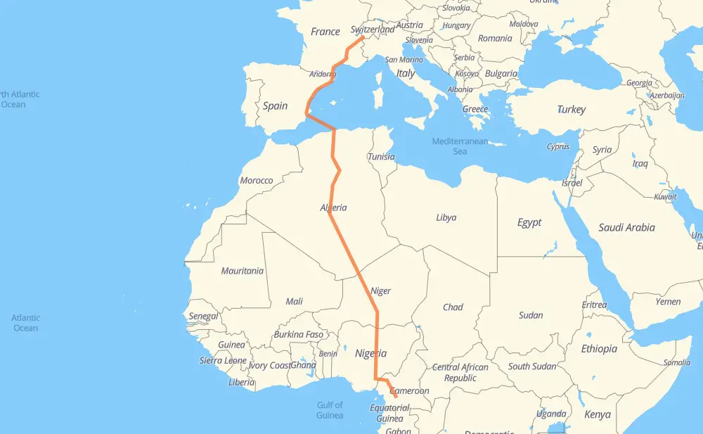
Distance between Saxé and Oman
The distance from Saxé to Oman is 4,138 miles by road including 963 miles on motorways. Road takes approximately 95 hours and 1 minute and goes through Grenoble, Nîmes, Montpellier, Perpiñán, Castellón de la Plana, Algiers and Blida.
| Shortest distance by air | 2,951 mi ✈️ |
| Car route length | 4,138.3 mi 🚗 |
| Driving time | 95 h 1 min |
| Fuel amount | 140.8 gal |
| Fuel cost | 553.2 USD |
| Point | Distance | Time | Fuel | |
| Saxé | 0 mi | 00 min | 0.0 gal | |
|
A 41 126 mi, 2 h 22 min
|
||||
| Grenoble | 126 mi | 2 h 22 min | 4.2 gal | |
|
A 480 A 7 150 mi, 2 h 17 min
|
||||
| Nîmes | 276 mi | 4 h 40 min | 9.3 gal | |
|
A 9 30 mi, 26 min
|
||||
| Montpellier | 306 mi | 5 h 06 min | 10.3 gal | |
|
A 9 94 mi, 1 h 22 min
|
||||
| Perpiñán | 400 mi | 6 h 29 min | 13.5 gal | |
|
A 9 AP-7 693 mi, 25 h 32 min
|
||||
| Blida | 1,093 mi | 32 h 01 min | 37.1 gal | |
|
A1 RN 1 16 mi, 17 min
|
||||
| Medea | 1,109 mi | 32 h 19 min | 37.5 gal | |
|
RN 1 78 mi, 1 h 32 min
|
||||
| Ain Oussara | 1,187 mi | 33 h 51 min | 39.8 gal | |
|
RN 1 62 mi, 1 h 15 min
|
||||
| Djelfa | 1,248 mi | 35 h 07 min | 42.0 gal | |
|
RN 1 63 mi, 1 h 13 min
|
||||
| Laghouat | 1,312 mi | 36 h 21 min | 44.3 gal | |
|
RN 1 116 mi, 2 h 07 min
|
||||
| Ghardaia | 1,428 mi | 38 h 28 min | 48.4 gal | |
|
RN 1 1,348 mi, 27 h 09 min
|
||||
| Arlit | 2,776 mi | 65 h 38 min | 94.4 gal | |
|
N 25 149 mi, 2 h 40 min
|
||||
| Agadez | 2,925 mi | 68 h 19 min | 99.5 gal | |
|
N 25 N 11 178 mi, 3 h 25 min
|
||||
| Tanout | 3,103 mi | 71 h 44 min | 105.4 gal | |
|
N 11 94 mi, 1 h 53 min
|
||||
| Zinder | 3,197 mi | 73 h 38 min | 108.7 gal | |
|
N 11 50 mi, 1 h 00 min
|
||||
| Magaria | 3,247 mi | 74 h 38 min | 109.8 gal | |
|
N 11 F.244 101 mi, 2 h 00 min
|
||||
| Kano | 3,348 mi | 76 h 39 min | 113.9 gal | |
|
A2 A3 316 mi, 6 h 13 min
|
||||
| Lafia | 3,664 mi | 82 h 52 min | 124.4 gal | |
|
A3 N6 355 mi, 7 h 06 min
|
||||
| Bamenda | 4,018 mi | 89 h 58 min | 136.7 gal | |
|
N6 48 mi, 57 min
|
||||
| Bafoussam | 4,066 mi | 90 h 55 min | 138.3 gal | |
|
N6 N4 102 mi, 2 h 02 min
|
||||
| Bafia | 4,169 mi | 92 h 58 min | 141.5 gal | |
|
N4 80 mi, 1 h 36 min
|
||||
| Yaounde | 4,249 mi | 94 h 34 min | 144.4 gal | |
|
N1 N2 22 mi, 26 min
|
||||
| Oman | 4,271 mi | 95 h 01 min | 145.2 gal | |
Frequently Asked Questions
How much does it cost to drive from Saxé to Oman?
Fuel cost: 553.2 USD
This fuel cost is calculated as: (Route length 4,138.3 mi) / (Fuel consumption 29.4 mpg) * (Fuel price 3.93 USD / gal)
You can adjust fuel consumption and fuel price here.
How long is a car ride from Saxé to Oman?
Driving time: 95 h 1 min
This time is calculated for driving at the maximum permitted speed, taking into account traffic rules restrictions.
- 638 mi with a maximum speed 68 mph = 9 h 22 min
- 150 mi with a maximum speed 62 mph = 2 h 24 min
- 898 mi with a maximum speed 56 mph = 16 h 2 min
- 25 mi with a maximum speed 56 mph = 27 min
- 2,124 mi with a maximum speed 50 mph = 42 h 43 min
- 8 mi with a maximum speed 43 mph = 10 min
- 171 mi with a maximum speed 37 mph = 4 h 35 min
- 25 mi with a maximum speed 31 mph = 48 min
- 3 mi with a maximum speed 25 mph = 8 min
- 1 mi with a maximum speed 19 mph = 2 min
- 227 mi with a maximum speed 12 mph = 18 h 14 min
The calculated driving time does not take into account intermediate stops and traffic jams.
How far is Saxé to Oman by land?
The distance between Saxé and Oman is 4,138.3 mi by road including 963.1 mi on motorways.
Precise satellite coordinates of highways were used for this calculation. The start and finish points are the centers of Saxé and Oman respectively.
How far is Saxé to Oman by plane?
The shortest distance (air line, as the crow flies) between Saxé and Oman is 2,950.9 mi.
This distance is calculated using the Haversine formula as a great-circle distance between two points on the surface of a sphere. The start and finish points are the centers of Saxé and Oman respectively. Actual distance between airports may be different.
How many hours is Saxé from Oman by plane?
Boeing 737 airliner needs 5 h 56 min to cover the distance of 2,951 mi at a cruising speed of 497 mph.
Small plane "Cessna 172" needs 21 h 35 min to flight this distance at average speed of 136 mph.
This time is approximate and do not take into account takeoff and landing times, airport location and other real world factors.
How long is a helicopter ride from Saxé to Oman?
Fast helicopter "Eurocopter AS350" or "Hughes OH-6 Cayuse" need 19 h 47 min to cover the distance of 2,951 mi at a cruising speed of 149 mph.
Popular "Robinson R44" needs 22 h 36 min to flight this distance at average speed of 130 mph.
This time is approximate and do not take into account takeoff and landing times, aerodrome location and other real world factors.
What city is halfway between Saxé and Oman?
The halfway point between Saxé and Oman is In Amguel. It is located about 88 mi from the exact midpoint by road.
The distance from In Amguel to Saxé is 2,157 mi and driving will take about 53 h 9 min. The road between In Amguel and Oman has length 1,981 mi and will take approximately 41 h 52 min.
The other cities located close to halfway point:
Where is Saxé in relation to Oman?
Saxé is located 2,951 mi north of Oman.
Saxé has geographic coordinates: latitude 46.14943, longitude 7.13171.
Oman has geographic coordinates: latitude 3.62441, longitude 11.48439.
Which highway goes from Saxé to Oman?
The route from Saxé to Oman follows RN 1, N 25, N 11, AP-7, A3, N6, A 9, N4, A-7, F.243.
Other minor sections pass along the road:
- F.244: 59 mi
- A 7: 58 mi
- A2: 53 mi
- A236: 53 mi
- A4: 51 mi
- A 49: 38 mi
- N 4: 30 mi
- A1: 25 mi
- A 41: 24 mi
- D 1212: 22 mi
- N1: 19 mi
- N2: 15 mi
- 203: 13 mi
- V-21: 11 mi
- A 43: 11 mi
- D 1506: 11 mi
- A 430: 10 mi
- N 205: 10 mi
- V-31: 9 mi
- N 532: 7 mi
- A 48: 6 mi
- N 7: 6 mi
- A-77: 4 mi
- A344: 4 mi
- D 909: 4 mi
- A9: 3 mi
- N3: 3 mi
- D 1090: 2 mi
- N 1: 2 mi
- A-31: 2 mi
- A 480: 2 mi
- A-70: 2 mi
- N 90: 2 mi
- 21: 1 mi
- ط و 1: 1 mi
- RN 11: 1 mi
- RN 8: 1 mi