Distance between Springfield and Makoro
The distance from Springfield to Makoro is 3,519 miles by road including 323 miles on motorways. Road takes approximately 67 hours and 39 minutes and goes through Pietermaritzburg, Mokopane, Louis Trichardt, Masvingo, Harare, Tete and Mzuzu.
| Shortest distance by air | 2,279 mi ✈️ |
| Car route length | 3,518.8 mi 🚗 |
| Driving time | 67 h 39 min |
| Fuel amount | 119.7 gal |
| Fuel cost | 470.4 USD |
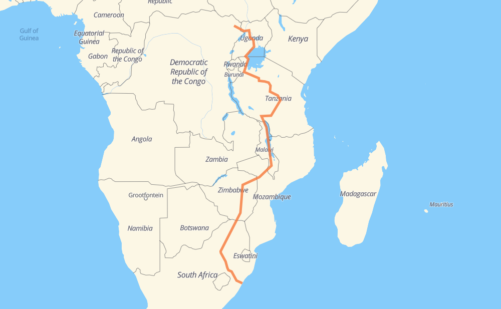
| Point | Distance | Time | Fuel | |
| -29.82056, 30.99500 | 0 mi | 00 min | 0.0 gal | |
|
N3 48 mi, 45 min
|
||||
| Pietermaritzburg | 48 mi | 45 min | 3.2 gal | |
|
N3 461 mi, 7 h 35 min
|
||||
| Mokopane | 510 mi | 8 h 20 min | 18.9 gal | |
|
N1 104 mi, 1 h 55 min
|
||||
| Louis Trichardt | 614 mi | 10 h 16 min | 22.3 gal | |
|
N1 A4 246 mi, 4 h 26 min
|
||||
| Masvingo | 861 mi | 14 h 42 min | 30.8 gal | |
|
A4 183 mi, 3 h 16 min
|
||||
| Harare | 1,043 mi | 17 h 59 min | 37.0 gal | |
|
R5 A2 234 mi, 4 h 19 min
|
||||
| Tete | 1,278 mi | 22 h 18 min | 45.0 gal | |
|
N7 M5 449 mi, 8 h 40 min
|
||||
| Mzuzu | 1,726 mi | 30 h 59 min | 60.0 gal | |
|
M5 M1 411 mi, 8 h 24 min
|
||||
| Iringa | 2,138 mi | 39 h 24 min | 73.1 gal | |
|
T1 T5 192 mi, 4 h 14 min
|
||||
| Dodoma | 2,330 mi | 43 h 39 min | 80.5 gal | |
|
T3 598 mi, 11 h 52 min
|
||||
| Bukoba | 2,928 mi | 55 h 31 min | 101.1 gal | |
|
T4 109 mi, 2 h 11 min
|
||||
| Masaka | 3,037 mi | 57 h 43 min | 104.9 gal | |
|
BWAISE I 14302 386 mi, 7 h 37 min
|
||||
| Arua | 3,423 mi | 65 h 20 min | 118.0 gal | |
|
RP434 96 mi, 2 h 18 min
|
||||
| Makoro | 3,519 mi | 67 h 39 min | 121.0 gal | |
Frequently Asked Questions
How much does it cost to drive from Springfield to Makoro?
Fuel cost: 470.4 USD
This fuel cost is calculated as: (Route length 3,518.8 mi) / (Fuel consumption 29.4 mpg) * (Fuel price 3.93 USD / gal)
You can adjust fuel consumption and fuel price here.
How long is a car ride from Springfield to Makoro?
Driving time: 67 h 39 min
This time is calculated for driving at the maximum permitted speed, taking into account traffic rules restrictions.
- 208 mi with a maximum speed 68 mph = 3 h 3 min
- 111 mi with a maximum speed 62 mph = 1 h 47 min
- 1,406 mi with a maximum speed 56 mph = 25 h 6 min
- 1,651 mi with a maximum speed 50 mph = 33 h 12 min
- 7 mi with a maximum speed 43 mph = 9 min
- 7 mi with a maximum speed 37 mph = 10 min
- 128 mi with a maximum speed 31 mph = 4 h 7 min
- 1 mi with a maximum speed 25 mph = 1 min
The calculated driving time does not take into account intermediate stops and traffic jams.
How far is Springfield to Makoro by land?
The distance between Springfield and Makoro is 3,518.8 mi by road including 323.1 mi on motorways.
Precise satellite coordinates of highways were used for this calculation. The start and finish points are the centers of Springfield and Makoro respectively.
How far is Springfield to Makoro by plane?
The shortest distance (air line, as the crow flies) between Springfield and Makoro is 2,278.6 mi.
This distance is calculated using the Haversine formula as a great-circle distance between two points on the surface of a sphere. The start and finish points are the centers of Springfield and Makoro respectively. Actual distance between airports may be different.
How many hours is Springfield from Makoro by plane?
Boeing 737 airliner needs 4 h 35 min to cover the distance of 2,279 mi at a cruising speed of 497 mph.
Small plane "Cessna 172" needs 16 h 40 min to flight this distance at average speed of 136 mph.
This time is approximate and do not take into account takeoff and landing times, airport location and other real world factors.
How long is a helicopter ride from Springfield to Makoro?
Fast helicopter "Eurocopter AS350" or "Hughes OH-6 Cayuse" need 15 h 16 min to cover the distance of 2,279 mi at a cruising speed of 149 mph.
Popular "Robinson R44" needs 17 h 27 min to flight this distance at average speed of 130 mph.
This time is approximate and do not take into account takeoff and landing times, aerodrome location and other real world factors.
What city is halfway between Springfield and Makoro?
The halfway point between Springfield and Makoro is Enukweni. It is located about 3 mi from the exact midpoint by road.
The distance from Enukweni to Springfield is 1,763 mi and driving will take about 31 h 41 min. The road between Enukweni and Makoro has length 1,756 mi and will take approximately 35 h 58 min.
The other cities located close to halfway point:
Where is Springfield in relation to Makoro?
Springfield is located 2,279 mi south of Makoro.
Springfield has geographic coordinates: latitude -29.82056, longitude 30.995.
Makoro has geographic coordinates: latitude 3.13359, longitude 29.88307.
Which highway goes from Springfield to Makoro?
The route from Springfield to Makoro follows T3, A4, N3, N1, M5, M1, T1, T5, T4, A2, N7, T10.
Other minor sections pass along the road:
- M6: 35 mi
- N8: 30 mi
- T9: 25 mi
- T8: 24 mi
- N4: 6 mi
- MASAKA KAKUTO ROAD: 6 mi
- N12: 4 mi
- BWAISE I 14302: 4 mi
- R523: 3 mi
- M10: 2 mi
- R5: 1 mi
- R2: 1 mi
- N1 section 21 North: 1 mi
- RP434: 1 mi