Distance between Sungai Buloh and Tabas
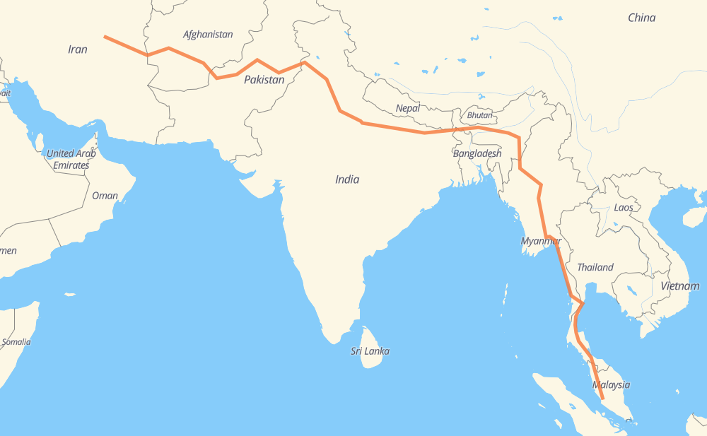
The distance from Sungai Buloh to Tabas is 5,001 miles by road including 803 miles on motorways. Road takes approximately 93 hours and 10 minutes and goes through Nibong Tebal, Dawei, Mawlamyine, Thaton, Sagaing, Monywa and Darbhanga.
| Shortest distance by air | 3,557 mi ✈️ |
| Car route length | 5,000.8 mi 🚗 |
| Driving time | 93 h 10 min |
| Fuel amount | 170.1 gal |
| Fuel cost | 668.5 USD |
| Point | Distance | Time | Fuel | |
| Sungai Buloh | 0 mi | 00 min | 0.0 gal | |
|
E1 187 mi, 2 h 52 min
|
||||
| Nibong Tebal | 187 mi | 2 h 52 min | 6.3 gal | |
|
E1 41 801 mi, 15 h 14 min
|
||||
| Dawei | 988 mi | 18 h 06 min | 33.4 gal | |
|
8 199 mi, 3 h 50 min
|
||||
| Mawlamyine | 1,187 mi | 21 h 57 min | 40.0 gal | |
|
8 39 mi, 46 min
|
||||
| Thaton | 1,227 mi | 22 h 43 min | 41.6 gal | |
|
1 419 mi, 7 h 17 min
|
||||
| Sagaing | 1,645 mi | 30 h 00 min | 55.7 gal | |
|
70 mi, 1 h 21 min
|
||||
| Monywa | 1,715 mi | 31 h 22 min | 58.2 gal | |
|
NH27 1,009 mi, 18 h 58 min
|
||||
| Darbhanga | 2,725 mi | 50 h 20 min | 92.5 gal | |
|
NH27 181 mi, 3 h 28 min
|
||||
| Gorakhpur | 2,906 mi | 53 h 49 min | 98.8 gal | |
|
NH24 NH27 66 mi, 1 h 13 min
|
||||
| Chhawani | 2,973 mi | 55 h 02 min | 101.0 gal | |
|
NH27 83 mi, 1 h 32 min
|
||||
| Barabanki | 3,055 mi | 56 h 34 min | 103.8 gal | |
|
NH27 NH34 223 mi, 4 h 08 min
|
||||
| Aligarh | 3,278 mi | 60 h 43 min | 111.4 gal | |
|
NH34 41 mi, 47 min
|
||||
| Bulandshahr | 3,319 mi | 61 h 31 min | 112.7 gal | |
|
NH34 NH44 99 mi, 1 h 47 min
|
||||
| Panipat | 3,418 mi | 63 h 19 min | 116.2 gal | |
|
NH44 21 mi, 24 min
|
||||
| Karnal | 3,439 mi | 63 h 43 min | 116.9 gal | |
|
NH44 53 mi, 1 h 01 min
|
||||
| Ambala | 3,491 mi | 64 h 44 min | 118.7 gal | |
|
NH44 65 mi, 1 h 15 min
|
||||
| Ludhiana | 3,557 mi | 66 h 00 min | 121.0 gal | |
|
NH44 41 mi, 46 min
|
||||
| Jalandhar | 3,598 mi | 66 h 46 min | 122.3 gal | |
|
NH3 48 mi, 55 min
|
||||
| Amritsar | 3,646 mi | 67 h 41 min | 123.9 gal | |
|
M-3 213 mi, 3 h 42 min
|
||||
| Atharan Hazari | 3,859 mi | 71 h 24 min | 130.5 gal | |
|
50 mi, 1 h 00 min
|
||||
| Bhakkar | 3,909 mi | 72 h 24 min | 132.9 gal | |
|
N-50 151 mi, 2 h 49 min
|
||||
| Zhob | 4,060 mi | 75 h 14 min | 137.7 gal | |
|
N-50 239 mi, 4 h 34 min
|
||||
| Chaman | 4,300 mi | 79 h 49 min | 146.0 gal | |
|
N-25 NH37 73 mi, 1 h 20 min
|
||||
| Kandahar | 4,373 mi | 81 h 10 min | 148.6 gal | |
|
NH0101 NH0102 258 mi, 4 h 39 min
|
||||
| Farah | 4,632 mi | 85 h 50 min | 157.3 gal | |
|
NH53 68 202 mi, 3 h 58 min
|
||||
| Birjand | 4,834 mi | 89 h 48 min | 164.3 gal | |
|
68 168 mi, 3 h 21 min
|
||||
| Tabas | 5,002 mi | 93 h 10 min | 170.1 gal | |
Frequently Asked Questions
How much does it cost to drive from Sungai Buloh to Tabas?
Fuel cost: 668.5 USD
This fuel cost is calculated as: (Route length 5,000.8 mi) / (Fuel consumption 29.4 mpg) * (Fuel price 3.93 USD / gal)
You can adjust fuel consumption and fuel price here.
How long is a car ride from Sungai Buloh to Tabas?
Driving time: 93 h 10 min
This time is calculated for driving at the maximum permitted speed, taking into account traffic rules restrictions.
- 378 mi with a maximum speed 68 mph = 5 h 33 min
- 330 mi with a maximum speed 62 mph = 5 h 18 min
- 1,750 mi with a maximum speed 56 mph = 31 h 15 min
- 176 mi with a maximum speed 56 mph = 3 h 9 min
- 2,334 mi with a maximum speed 50 mph = 46 h 56 min
- 9 mi with a maximum speed 43 mph = 12 min
- 19 mi with a maximum speed 37 mph = 30 min
- 4 mi with a maximum speed 31 mph = 7 min
- 1 mi with a maximum speed 12 mph = 5 min
The calculated driving time does not take into account intermediate stops and traffic jams.
How far is Sungai Buloh to Tabas by land?
The distance between Sungai Buloh and Tabas is 5,000.8 mi by road including 803.4 mi on motorways.
Precise satellite coordinates of highways were used for this calculation. The start and finish points are the centers of Sungai Buloh and Tabas respectively.
How far is Sungai Buloh to Tabas by plane?
The shortest distance (air line, as the crow flies) between Sungai Buloh and Tabas is 3,557.4 mi.
This distance is calculated using the Haversine formula as a great-circle distance between two points on the surface of a sphere. The start and finish points are the centers of Sungai Buloh and Tabas respectively. Actual distance between airports may be different.
How many hours is Sungai Buloh from Tabas by plane?
Boeing 737 airliner needs 7 h 9 min to cover the distance of 3,557 mi at a cruising speed of 497 mph.
Small plane "Cessna 172" needs 26 h 1 min to flight this distance at average speed of 136 mph.
This time is approximate and do not take into account takeoff and landing times, airport location and other real world factors.
How long is a helicopter ride from Sungai Buloh to Tabas?
Fast helicopter "Eurocopter AS350" or "Hughes OH-6 Cayuse" need 23 h 51 min to cover the distance of 3,557 mi at a cruising speed of 149 mph.
Popular "Robinson R44" needs 27 h 15 min to flight this distance at average speed of 130 mph.
This time is approximate and do not take into account takeoff and landing times, aerodrome location and other real world factors.
What city is halfway between Sungai Buloh and Tabas?
The halfway point between Sungai Buloh and Tabas is Mainaguri. It is located about 2 mi from the exact midpoint by road.
The distance from Mainaguri to Sungai Buloh is 2,502 mi and driving will take about 46 h 4 min. The road between Mainaguri and Tabas has length 2,499 mi and will take approximately 47 h 5 min.
The other cities located close to halfway point:
Where is Sungai Buloh in relation to Tabas?
Sungai Buloh is located 3,557 mi south-east of Tabas.
Sungai Buloh has geographic coordinates: latitude 3.21, longitude 101.55.
Tabas has geographic coordinates: latitude 33.59603, longitude 56.92473.
Which highway goes from Sungai Buloh to Tabas?
The route from Sungai Buloh to Tabas follows NH27, 8, N-50, 68, E1, 41, NH44, NH34, 4, NH0102, M-3, NH29, NH2, H01, NH0101, NH37, NH102.
Other minor sections pass along the road:
- NH3: 58 mi
- NH53: 57 mi
- NH427: 57 mi
- N-25: 55 mi
- 95: 38 mi
- NE2: 31 mi
- 91: 20 mi
- SH17: 17 mi
- NH131: 17 mi
- 334C: 16 mi
- 1: 15 mi
- MDR: 14 mi
- N-5: 14 mi
- NE-2: 14 mi
- NH17: 12 mi
- NH327: 11 mi
- SH19: 9 mi
- 27: 9 mi
- NH330: 7 mi
- SH74: 4 mi
- ปข.1039: 4 mi
- SH40: 4 mi
- 54: 4 mi
- 44: 4 mi
- NH57: 4 mi
- N-55: 3 mi
- M-2: 2 mi
- ปข.2082: 2 mi
- NH24: 1 mi
- E-4: 1 mi
- NH152: 1 mi
- NH30: 1 mi
- 28: 1 mi