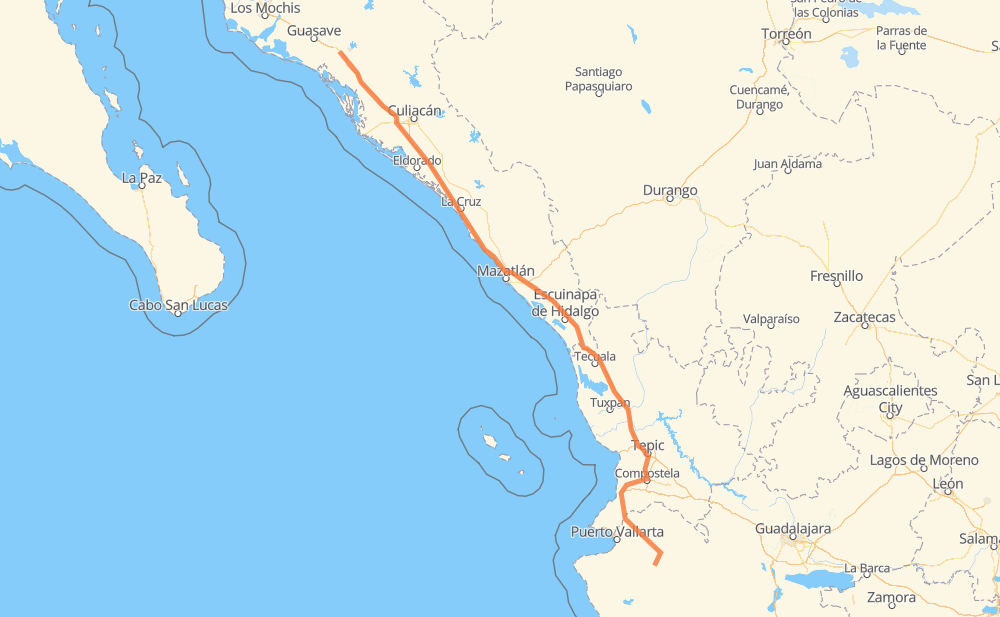
Distance between Talpa de Allende and Gabriel Leyva Velázquez (La Escalera)
The distance from Talpa de Allende to Gabriel Leyva Velázquez (La Escalera) is 507 miles by road including 370 miles on motorways. Road takes approximately 9 hours and 21 minutes and goes through Tepic, Dimas (Estación Dimas), Mascota, Las Varas, Compostela, Xalisco and El Rosario.
| Shortest distance by air | 411 mi ✈️ |
| Car route length | 507 mi 🚗 |
| Driving time | 9 h 21 min |
| Fuel amount | 17.2 gal |
| Fuel cost | 67.3 USD |
| Toll roads cost | 926 + ? MXN |
| Point | Distance | Time | Fuel | |
| Talpa de Allende | 0 mi | 00 min | 0.0 gal | |
|
JAL 527 MEX 90 17 mi, 26 min
|
||||
| Mascota | 17 mi | 26 min | 0.4 gal | |
|
MEX 90 80 mi, 1 h 45 min
|
||||
| Las Varas | 96 mi | 2 h 11 min | 3.3 gal | |
|
MEX 200 17 mi, 20 min
|
||||
| Compostela | 114 mi | 2 h 31 min | 3.4 gal | |
|
MEX 200 28 mi, 33 min
|
||||
| Xalisco | 142 mi | 3 h 04 min | 4.8 gal | |
|
MEX 200 6 mi, 07 min
|
||||
| Tepic | 148 mi | 3 h 11 min | 4.9 gal | |
|
MEX 15D 123 mi, 1 h 59 min
|
||||
| El Rosario | 272 mi | 5 h 11 min | 9.0 gal | |
|
MEX 15D 7 mi, 06 min
|
||||
| Otates | 278 mi | 5 h 18 min | 9.4 gal | |
|
MEX 15D 76 mi, 1 h 16 min
|
||||
| Dimas (Estación Dimas) | 355 mi | 6 h 34 min | 11.8 gal | |
|
MEX 15D 160 mi, 2 h 47 min
|
||||
| Gabriel Leyva Velázquez (La Escalera) | 515 mi | 9 h 21 min | 17.2 gal | |
Frequently Asked Questions
How many toll booths are there from Talpa de Allende to Gabriel Leyva Velázquez (La Escalera)?
There are 9 toll booths between Talpa de Allende and Gabriel Leyva Velázquez (La Escalera): Las Brisas, San Pedro km 197+100, Costa Rica, Marmol, El Rosario, Acaponeta, Ruiz, Trapichillo and El Pisal.
How much does the toll booths cost from Talpa de Allende to Gabriel Leyva Velázquez (La Escalera)?
Toll roads cost: Trapichillo (80 MXN) + Ruiz (?) + Acaponeta (240 MXN) + El Rosario (140 MXN) + Marmol (131 MXN) + Costa Rica (152 MXN) + San Pedro km 197+100 (34 MXN) + El Pisal (73 MXN) + Las Brisas (76 MXN) = 926 + ? MXN
How much does it cost to drive from Talpa de Allende to Gabriel Leyva Velázquez (La Escalera)?
Fuel cost: 67.3 USD
This fuel cost is calculated as: (Route length 507 mi) / (Fuel consumption 29.4 mpg) * (Fuel price 3.9 USD / gal)
You can adjust fuel consumption and fuel price here.
Toll roads cost: 926 + ? MXN
How long is a car ride from Talpa de Allende to Gabriel Leyva Velázquez (La Escalera)?
Driving time: 9 h 21 min
This time is calculated for driving at the maximum permitted speed, taking into account traffic rules restrictions.
- 57 mi with a maximum speed 68 mph = 50 min
- 231 mi with a maximum speed 62 mph = 3 h 43 min
- 6 mi with a maximum speed 56 mph = 5 min
- 17 mi with a maximum speed 56 mph = 18 min
- 160 mi with a maximum speed 50 mph = 3 h 12 min
- 11 mi with a maximum speed 43 mph = 15 min
- 24 mi with a maximum speed 37 mph = 38 min
- 9 mi with a maximum speed 31 mph = 16 min
The calculated driving time does not take into account intermediate stops and traffic jams.
How far is Talpa de Allende to Gabriel Leyva Velázquez (La Escalera) by land?
The distance between Talpa de Allende and Gabriel Leyva Velázquez (La Escalera) is 507 mi by road including 370.3 mi on motorways.
Precise satellite coordinates of highways were used for this calculation. The start and finish points are the centers of Talpa de Allende and Gabriel Leyva Velázquez (La Escalera) respectively.
How far is Talpa de Allende to Gabriel Leyva Velázquez (La Escalera) by plane?
The shortest distance (air line, as the crow flies) between Talpa de Allende and Gabriel Leyva Velázquez (La Escalera) is 410.7 mi.
This distance is calculated using the Haversine formula as a great-circle distance between two points on the surface of a sphere. The start and finish points are the centers of Talpa de Allende and Gabriel Leyva Velázquez (La Escalera) respectively. Actual distance between airports may be different.
How many hours is Talpa de Allende from Gabriel Leyva Velázquez (La Escalera) by plane?
Boeing 737 airliner needs 49 min to cover the distance of 411 mi at a cruising speed of 497 mph.
Small plane "Cessna 172" needs 3 h to flight this distance at average speed of 136 mph.
This time is approximate and do not take into account takeoff and landing times, airport location and other real world factors.
How long is a helicopter ride from Talpa de Allende to Gabriel Leyva Velázquez (La Escalera)?
Fast helicopter "Eurocopter AS350" or "Hughes OH-6 Cayuse" need 2 h 45 min to cover the distance of 411 mi at a cruising speed of 149 mph.
Popular "Robinson R44" needs 3 h 8 min to flight this distance at average speed of 130 mph.
This time is approximate and do not take into account takeoff and landing times, aerodrome location and other real world factors.
What city is halfway between Talpa de Allende and Gabriel Leyva Velázquez (La Escalera)?
The halfway point between Talpa de Allende and Gabriel Leyva Velázquez (La Escalera) is Ojo de Agua de Palmillas. It is located about 12 mi from the exact midpoint by road.
The distance from Ojo de Agua de Palmillas to Talpa de Allende is 241 mi and driving will take about 4 h 41 min. The road between Ojo de Agua de Palmillas and Gabriel Leyva Velázquez (La Escalera) has length 266 mi and will take approximately 4 h 40 min.
The other cities located close to halfway point:
Where is Talpa de Allende in relation to Gabriel Leyva Velázquez (La Escalera)?
Talpa de Allende is located 411 mi south-east of Gabriel Leyva Velázquez (La Escalera).
Talpa de Allende has geographic coordinates: latitude 20.3809, longitude -104.8225.
Gabriel Leyva Velázquez (La Escalera) has geographic coordinates: latitude 25.44859, longitude -108.19658.
Which highway goes from Talpa de Allende to Gabriel Leyva Velázquez (La Escalera)?
The route from Talpa de Allende to Gabriel Leyva Velázquez (La Escalera) follows MEX 15D.
Other minor sections pass along the road:
- MEX 200: 53 mi
- MEX 90: 52 mi
- MEX 70: 10 mi
- JAL 527: 6 mi