Distance between Tapachula and Guadalupe Magueyes (Magueyes)
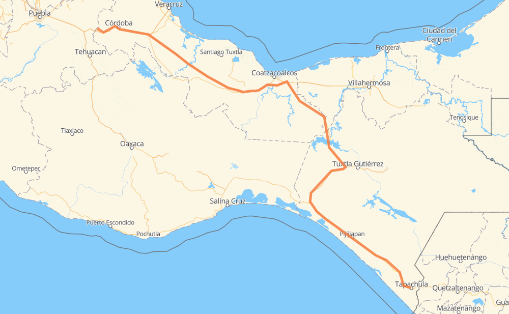
The distance from Tapachula to Guadalupe Magueyes (Magueyes) is 574 miles by road including 232 miles on motorways. Road takes approximately 10 hours and 7 minutes and goes through Orizaba, Viva Mexico, Álvaro Obregón, Huehuetan, Huixtla, Mapastepec and 8 de Septiembre.
| Shortest distance by air | 429 mi ✈️ |
| Car route length | 573.5 mi 🚗 |
| Driving time | 10 h 7 min |
| Fuel amount | 19.5 gal |
| Fuel cost | 76.1 USD |
| Toll roads cost | 732 + ? MXN |
| Point | Distance | Time | Fuel | |
| Tapachula | 0 mi | 00 min | 0.0 gal | |
|
MEX 200 8 mi, 09 min
|
||||
| Álvaro Obregón | 8 mi | 09 min | 0.1 gal | |
|
MEX 200 7 mi, 08 min
|
||||
| Huehuetan | 16 mi | 17 min | 0.5 gal | |
|
MEX 200 11 mi, 11 min
|
||||
| Huixtla | 27 mi | 29 min | 0.8 gal | |
|
MEX 200 39 mi, 43 min
|
||||
| Mapastepec | 66 mi | 1 h 13 min | 2.1 gal | |
|
MEX 200 4 mi, 04 min
|
||||
| 8 de Septiembre | 70 mi | 1 h 17 min | 2.4 gal | |
|
MEX 200 22 mi, 23 min
|
||||
| Pijijiapan | 91 mi | 1 h 41 min | 3.0 gal | |
|
MEX 200 47 mi, 51 min
|
||||
| Tonalá | 138 mi | 2 h 32 min | 4.6 gal | |
|
MEX 200 MEX 180D 412 mi, 7 h 06 min
|
||||
| Orizaba | 550 mi | 9 h 38 min | 18.6 gal | |
|
MEX 150D 23 mi, 28 min
|
||||
| Guadalupe Magueyes (Magueyes) | 574 mi | 10 h 06 min | 19.3 gal | |
Frequently Asked Questions
How many toll booths are there from Tapachula to Guadalupe Magueyes (Magueyes)?
There are 11 toll booths between Tapachula and Guadalupe Magueyes (Magueyes): Fortín, Cuitláhuac, Cosamaloapan, Acayucan, Antonio Dovali, Las Choapas, Arriaga, Jiquipilas, Ocozocoautla, Ocozocoautla 182 and Malpasito.
How much does the toll booths cost from Tapachula to Guadalupe Magueyes (Magueyes)?
Toll roads cost: Arriaga (37 MXN) + Jiquipilas (15-60 MXN) + Ocozocoautla (38 MXN) + Ocozocoautla 182 (82 MXN) + Malpasito (82 MXN) + Las Choapas (82 MXN) + Antonio Dovali (20 MXN) + Acayucan (?) + Cosamaloapan (229 MXN) + Cuitláhuac (114 MXN) + Fortín (33 MXN) = 732 + ? MXN
How much does it cost to drive from Tapachula to Guadalupe Magueyes (Magueyes)?
Fuel cost: 76.1 USD
This fuel cost is calculated as: (Route length 573.5 mi) / (Fuel consumption 29.4 mpg) * (Fuel price 3.9 USD / gal)
You can adjust fuel consumption and fuel price here.
Toll roads cost: 732 + ? MXN
How long is a car ride from Tapachula to Guadalupe Magueyes (Magueyes)?
Driving time: 10 h 7 min
This time is calculated for driving at the maximum permitted speed, taking into account traffic rules restrictions.
- 38 mi with a maximum speed 68 mph = 33 min
- 145 mi with a maximum speed 62 mph = 2 h 19 min
- 258 mi with a maximum speed 56 mph = 4 h 36 min
- 28 mi with a maximum speed 56 mph = 30 min
- 103 mi with a maximum speed 50 mph = 2 h 4 min
- 1 mi with a maximum speed 31 mph = 1 min
The calculated driving time does not take into account intermediate stops and traffic jams.
How far is Tapachula to Guadalupe Magueyes (Magueyes) by land?
The distance between Tapachula and Guadalupe Magueyes (Magueyes) is 573.5 mi by road including 231.8 mi on motorways.
Precise satellite coordinates of highways were used for this calculation. The start and finish points are the centers of Tapachula and Guadalupe Magueyes (Magueyes) respectively.
How far is Tapachula to Guadalupe Magueyes (Magueyes) by plane?
The shortest distance (air line, as the crow flies) between Tapachula and Guadalupe Magueyes (Magueyes) is 429.4 mi.
This distance is calculated using the Haversine formula as a great-circle distance between two points on the surface of a sphere. The start and finish points are the centers of Tapachula and Guadalupe Magueyes (Magueyes) respectively. Actual distance between airports may be different.
How many hours is Tapachula from Guadalupe Magueyes (Magueyes) by plane?
Boeing 737 airliner needs 51 min to cover the distance of 429 mi at a cruising speed of 497 mph.
Small plane "Cessna 172" needs 3 h 8 min to flight this distance at average speed of 136 mph.
This time is approximate and do not take into account takeoff and landing times, airport location and other real world factors.
How long is a helicopter ride from Tapachula to Guadalupe Magueyes (Magueyes)?
Fast helicopter "Eurocopter AS350" or "Hughes OH-6 Cayuse" need 2 h 52 min to cover the distance of 429 mi at a cruising speed of 149 mph.
Popular "Robinson R44" needs 3 h 17 min to flight this distance at average speed of 130 mph.
This time is approximate and do not take into account takeoff and landing times, aerodrome location and other real world factors.
What city is halfway between Tapachula and Guadalupe Magueyes (Magueyes)?
The halfway point between Tapachula and Guadalupe Magueyes (Magueyes) is Llano Verde. It is located about 15 mi from the exact midpoint by road.
The distance from Llano Verde to Tapachula is 301 mi and driving will take about 5 h 29 min. The road between Llano Verde and Guadalupe Magueyes (Magueyes) has length 272 mi and will take approximately 4 h 37 min.
The other cities located close to halfway point:
Where is Tapachula in relation to Guadalupe Magueyes (Magueyes)?
Tapachula is located 429 mi south-east of Guadalupe Magueyes (Magueyes).
Tapachula has geographic coordinates: latitude 14.90994, longitude -92.26497.
Guadalupe Magueyes (Magueyes) has geographic coordinates: latitude 18.87167, longitude -97.27083.
Which highway goes from Tapachula to Guadalupe Magueyes (Magueyes)?
The route from Tapachula to Guadalupe Magueyes (Magueyes) follows MEX 200, MEX 180D, MEX 145D, MEX 150D.
Other minor sections pass along the road:
- MEX 195D: 43 mi
- MEX 190D: 14 mi
- MEX 190: 4 mi
- MEX 180: 4 mi
- Tapachula Arriaga: 1 mi