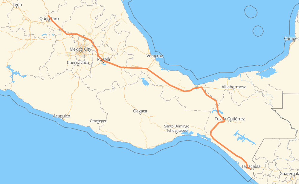
Distance between Tapachula and Puerto de Aguirre
The distance from Tapachula to Puerto de Aguirre is 856 miles by road including 511 miles on motorways. Road takes approximately 15 hours and 2 minutes and goes through Orizaba, San Juan del Rio, Viva Mexico, Álvaro Obregón, Huehuetan, Huixtla and Mapastepec.
| Shortest distance by air | 674 mi ✈️ |
| Car route length | 856.2 mi 🚗 |
| Driving time | 15 h 2 min |
| Fuel amount | 29.1 gal |
| Fuel cost | 113.6 USD |
| Toll roads cost | 1,207 + ? MXN |
| Point | Distance | Time | Fuel | |
| Tapachula | 0 mi | 00 min | 0.0 gal | |
|
MEX 200 8 mi, 09 min
|
||||
| Álvaro Obregón | 8 mi | 09 min | 0.1 gal | |
|
MEX 200 7 mi, 08 min
|
||||
| Huehuetan | 16 mi | 17 min | 0.5 gal | |
|
MEX 200 11 mi, 11 min
|
||||
| Huixtla | 27 mi | 29 min | 0.8 gal | |
|
MEX 200 39 mi, 43 min
|
||||
| Mapastepec | 66 mi | 1 h 13 min | 2.1 gal | |
|
MEX 200 4 mi, 04 min
|
||||
| 8 de Septiembre | 70 mi | 1 h 17 min | 2.4 gal | |
|
MEX 200 22 mi, 23 min
|
||||
| Pijijiapan | 91 mi | 1 h 41 min | 3.0 gal | |
|
MEX 200 MEX 180D 459 mi, 7 h 57 min
|
||||
| Orizaba | 550 mi | 9 h 38 min | 18.6 gal | |
|
MEX 150D 263 mi, 4 h 35 min
|
||||
| San Juan del Rio | 813 mi | 14 h 14 min | 27.6 gal | |
|
MEX 57 MEX 57D 43 mi, 48 min
|
||||
| Parque Industrial Queretaro | 856 mi | 15 h 02 min | 29.1 gal | |
Frequently Asked Questions
How many toll booths are there from Tapachula to Puerto de Aguirre?
There are 19 toll booths between Tapachula and Puerto de Aguirre: Fortín, Cuitláhuac, Cosamaloapan, Acayucan, Antonio Dovali, Las Choapas, Chichimequillas, Queretaro, Palmillas, San Martin Texmelucan, San Martín, Amozoc 2, Amozoc, Esperanza 27, Arriaga, Jiquipilas, Ocozocoautla, Ocozocoautla 182 and Malpasito.
How much does the toll booths cost from Tapachula to Puerto de Aguirre?
Toll roads cost: Arriaga (37 MXN) + Jiquipilas (15-60 MXN) + Ocozocoautla (38 MXN) + Ocozocoautla 182 (82 MXN) + Malpasito (82 MXN) + Las Choapas (82 MXN) + Antonio Dovali (20 MXN) + Acayucan (?) + Cosamaloapan (229 MXN) + Cuitláhuac (114 MXN) + Fortín (33 MXN) + Esperanza 27 (140 MXN) + Amozoc (72 MXN) + Amozoc 2 (81 MXN) + San Martín (42 MXN) + San Martin Texmelucan (?) + Queretaro (?) + Palmillas (89 MXN) + Chichimequillas (51 MXN) = 1,207 + ? MXN
How much does it cost to drive from Tapachula to Puerto de Aguirre?
Fuel cost: 113.6 USD
This fuel cost is calculated as: (Route length 856.2 mi) / (Fuel consumption 29.4 mpg) * (Fuel price 3.9 USD / gal)
You can adjust fuel consumption and fuel price here.
Toll roads cost: 1,207 + ? MXN
How long is a car ride from Tapachula to Puerto de Aguirre?
Driving time: 15 h 2 min
This time is calculated for driving at the maximum permitted speed, taking into account traffic rules restrictions.
- 54 mi with a maximum speed 68 mph = 47 min
- 316 mi with a maximum speed 62 mph = 5 h 5 min
- 259 mi with a maximum speed 56 mph = 4 h 37 min
- 31 mi with a maximum speed 56 mph = 33 min
- 190 mi with a maximum speed 50 mph = 3 h 49 min
- 2 mi with a maximum speed 43 mph = 3 min
- 2 mi with a maximum speed 31 mph = 3 min
- 1 mi with a maximum speed 25 mph = 1 min
The calculated driving time does not take into account intermediate stops and traffic jams.
How far is Tapachula to Puerto de Aguirre by land?
The distance between Tapachula and Puerto de Aguirre is 856.2 mi by road including 511.4 mi on motorways.
Precise satellite coordinates of highways were used for this calculation. The start and finish points are the centers of Tapachula and Puerto de Aguirre respectively.
How far is Tapachula to Puerto de Aguirre by plane?
The shortest distance (air line, as the crow flies) between Tapachula and Puerto de Aguirre is 674.2 mi.
This distance is calculated using the Haversine formula as a great-circle distance between two points on the surface of a sphere. The start and finish points are the centers of Tapachula and Puerto de Aguirre respectively. Actual distance between airports may be different.
How many hours is Tapachula from Puerto de Aguirre by plane?
Boeing 737 airliner needs 1 h 21 min to cover the distance of 674 mi at a cruising speed of 497 mph.
Small plane "Cessna 172" needs 4 h 55 min to flight this distance at average speed of 136 mph.
This time is approximate and do not take into account takeoff and landing times, airport location and other real world factors.
How long is a helicopter ride from Tapachula to Puerto de Aguirre?
Fast helicopter "Eurocopter AS350" or "Hughes OH-6 Cayuse" need 4 h 31 min to cover the distance of 674 mi at a cruising speed of 149 mph.
Popular "Robinson R44" needs 5 h 10 min to flight this distance at average speed of 130 mph.
This time is approximate and do not take into account takeoff and landing times, aerodrome location and other real world factors.
What city is halfway between Tapachula and Puerto de Aguirre?
The halfway point between Tapachula and Puerto de Aguirre is Pichoapa. It is located about 24 mi from the exact midpoint by road.
The distance from Pichoapa to Tapachula is 451 mi and driving will take about 8 h 4 min. The road between Pichoapa and Puerto de Aguirre has length 405 mi and will take approximately 6 h 58 min.
The other cities located close to halfway point:
Where is Tapachula in relation to Puerto de Aguirre?
Tapachula is located 674 mi south-east of Puerto de Aguirre.
Tapachula has geographic coordinates: latitude 14.90994, longitude -92.26497.
Puerto de Aguirre has geographic coordinates: latitude 20.80707, longitude -100.43016.
Which highway goes from Tapachula to Puerto de Aguirre?
The route from Tapachula to Puerto de Aguirre follows MEX 150D, MEX 200, MEX 180D, MEX 145D, MEX M40D.
Other minor sections pass along the road:
- MEX 57D: 57 mi
- MEX 195D: 43 mi
- MEX 57: 27 mi
- MEX 45: 25 mi
- MEX 190D: 14 mi
- MEX 120: 7 mi
- MEX 190: 4 mi
- MEX 180: 4 mi
- Tapachula Arriaga: 1 mi
- MEX 140D: 1 mi