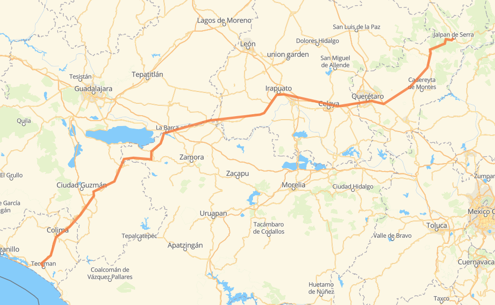
Distance between Tecoman and Jalpan de Serra
The distance from Tecoman to Jalpan de Serra is 430 miles by road including 142 miles on motorways. Road takes approximately 8 hours and 15 minutes and goes through Colima, Irapuato, Salamanca, Celaya and Querétaro.
| Shortest distance by air | 327 mi ✈️ |
| Car route length | 430 mi 🚗 |
| Driving time | 8 h 15 min |
| Fuel amount | 14.6 gal |
| Fuel cost | 57.5 USD |
| Toll roads cost | 165 + ? MXN |
| Point | Distance | Time | Fuel | |
| Tecoman | 0 mi | 00 min | 0.0 gal | |
|
MEX 200 MEX 110D 29 mi, 29 min
|
||||
| Colima | 29 mi | 29 min | 0.9 gal | |
|
MEX 54D 11 mi, 10 min
|
||||
| Cuauhtémoc | 40 mi | 40 min | 1.2 gal | |
|
MEX 54D 24 mi, 24 min
|
||||
| Tuxpan | 64 mi | 1 h 04 min | 2.0 gal | |
|
MEX 110 42 mi, 45 min
|
||||
| Mazamitla | 106 mi | 1 h 50 min | 3.5 gal | |
|
JAL 414 MEX 110 145 mi, 2 h 48 min
|
||||
| Irapuato | 251 mi | 4 h 38 min | 8.4 gal | |
|
MEX 45D 12 mi, 13 min
|
||||
| Salamanca | 263 mi | 4 h 52 min | 8.9 gal | |
|
MEX 45D 22 mi, 22 min
|
||||
| Celaya | 286 mi | 5 h 14 min | 9.6 gal | |
|
MEX 45D 29 mi, 25 min
|
||||
| Querétaro | 314 mi | 5 h 40 min | 10.6 gal | |
|
MEX 45D MEX 120 119 mi, 2 h 34 min
|
||||
| Jalpan de Serra | 434 mi | 8 h 15 min | 14.7 gal | |
Hotels of Jalpan de Serra
Frequently Asked Questions
How many toll booths are there from Tecoman to Jalpan de Serra?
There are 4 toll booths between Tecoman and Jalpan de Serra: Salamanca, Cerro Gordo, Querétaro 6 and Libramiento de La Piedad.
How much does the toll booths cost from Tecoman to Jalpan de Serra?
Toll roads cost: Libramiento de La Piedad (?) + Salamanca (83 MXN) + Cerro Gordo (?) + Querétaro 6 (82 MXN) = 165 + ? MXN
How much does it cost to drive from Tecoman to Jalpan de Serra?
Fuel cost: 57.5 USD
This fuel cost is calculated as: (Route length 430 mi) / (Fuel consumption 29.4 mpg) * (Fuel price 3.93 USD / gal)
You can adjust fuel consumption and fuel price here.
Toll roads cost: 165 + ? MXN
How long is a car ride from Tecoman to Jalpan de Serra?
Driving time: 8 h 15 min
This time is calculated for driving at the maximum permitted speed, taking into account traffic rules restrictions.
- 43 mi with a maximum speed 68 mph = 38 min
- 68 mi with a maximum speed 62 mph = 1 h 5 min
- 52 mi with a maximum speed 56 mph = 55 min
- 55 mi with a maximum speed 56 mph = 58 min
- 183 mi with a maximum speed 50 mph = 3 h 40 min
- 29 mi with a maximum speed 37 mph = 46 min
- 1 mi with a maximum speed 31 mph = 2 min
- 3 mi with a maximum speed 25 mph = 8 min
The calculated driving time does not take into account intermediate stops and traffic jams.
How far is Tecoman to Jalpan de Serra by land?
The distance between Tecoman and Jalpan de Serra is 430 mi by road including 142.3 mi on motorways.
Precise satellite coordinates of highways were used for this calculation. The start and finish points are the centers of Tecoman and Jalpan de Serra respectively.
How far is Tecoman to Jalpan de Serra by plane?
The shortest distance (air line, as the crow flies) between Tecoman and Jalpan de Serra is 326.8 mi.
This distance is calculated using the Haversine formula as a great-circle distance between two points on the surface of a sphere. The start and finish points are the centers of Tecoman and Jalpan de Serra respectively. Actual distance between airports may be different.
How many hours is Tecoman from Jalpan de Serra by plane?
Boeing 737 airliner needs 39 min to cover the distance of 327 mi at a cruising speed of 497 mph.
Small plane "Cessna 172" needs 2 h 23 min to flight this distance at average speed of 136 mph.
This time is approximate and do not take into account takeoff and landing times, airport location and other real world factors.
How long is a helicopter ride from Tecoman to Jalpan de Serra?
Fast helicopter "Eurocopter AS350" or "Hughes OH-6 Cayuse" need 2 h 11 min to cover the distance of 327 mi at a cruising speed of 149 mph.
Popular "Robinson R44" needs 2 h 30 min to flight this distance at average speed of 130 mph.
This time is approximate and do not take into account takeoff and landing times, aerodrome location and other real world factors.
What city is halfway between Tecoman and Jalpan de Serra?
The halfway point between Tecoman and Jalpan de Serra is Pénjamo. It is located about 1 mi from the exact midpoint by road.
The distance from Pénjamo to Tecoman is 216 mi and driving will take about 3 h 59 min. The road between Pénjamo and Jalpan de Serra has length 214 mi and will take approximately 4 h 16 min.
The other cities located close to halfway point:
Where is Tecoman in relation to Jalpan de Serra?
Tecoman is located 327 mi south-west of Jalpan de Serra.
Tecoman has geographic coordinates: latitude 18.91057, longitude -103.87312.
Jalpan de Serra has geographic coordinates: latitude 21.21941, longitude -99.47441.
Which highway goes from Tecoman to Jalpan de Serra?
The route from Tecoman to Jalpan de Serra follows MEX 110.
Other minor sections pass along the road:
- MEX 45D: 60 mi
- MEX 120: 56 mi
- QRO 100: 48 mi
- MEX 90: 45 mi
- MEX 54D: 28 mi
- MEX 110D: 19 mi
- MEX 90D: 13 mi
- MEX 45: 9 mi
- MEX 35: 7 mi
- MEX 57: 6 mi
- MEX 15: 6 mi
- MEX 45: 3 mi
- MEX 200: 3 mi
- JAL 414: 2 mi
- MICH 110: 1 mi