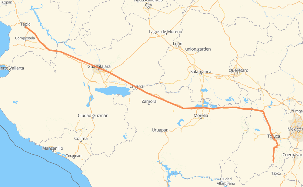
Distance between Tepic and Los Naranjos
The distance from Tepic to Los Naranjos is 458 miles by road including 423 miles on motorways. Road takes approximately 8 hours and 5 minutes and goes through Tonalá, Toluca, El Arenal, Campestre Agronomia, Vista Hermosa de Negrete, Ecuandureo and Panindicuaro.
| Shortest distance by air | 384 mi ✈️ |
| Car route length | 458 mi 🚗 |
| Driving time | 8 h 5 min |
| Fuel amount | 15.6 gal |
| Fuel cost | 60.8 USD |
| Toll roads cost | 989 + ? MXN |
| Point | Distance | Time | Fuel | |
| Tepic | 0 mi | 00 min | 0.0 gal | |
|
MEX 15 MEX 15D 98 mi, 1 h 34 min
|
||||
| El Arenal | 98 mi | 1 h 34 min | 3.0 gal | |
|
MEX 15D 14 mi, 13 min
|
||||
| Campestre Agronomia | 112 mi | 1 h 48 min | 3.7 gal | |
|
MEX 15D 23 mi, 28 min
|
||||
| Tonalá | 135 mi | 2 h 16 min | 4.4 gal | |
|
MEX 15D 58 mi, 1 h 09 min
|
||||
| Vista Hermosa de Negrete | 194 mi | 3 h 25 min | 6.5 gal | |
|
MEX 15D 17 mi, 18 min
|
||||
| Ecuandureo | 211 mi | 3 h 43 min | 7.1 gal | |
|
MEX 15D 33 mi, 36 min
|
||||
| Panindicuaro | 244 mi | 4 h 19 min | 8.2 gal | |
|
MEX 15D 19 mi, 19 min
|
||||
| Huaniqueo de Morales | 263 mi | 4 h 39 min | 8.9 gal | |
|
MEX 15D 153 mi, 2 h 38 min
|
||||
| Toluca | 416 mi | 7 h 18 min | 14.1 gal | |
|
MEX 55 42 mi, 47 min
|
||||
| Colonia Juárez | 458 mi | 8 h 05 min | 15.5 gal | |
Frequently Asked Questions
How many toll booths are there from Tepic to Los Naranjos?
There are 15 toll booths between Tepic and Los Naranjos: Santa Maria del Oro, Plan de Barrancas, La Joya, Ocotlán, Zinapecuaro, Contepec, Panindicuaro, Ecuandureo, La Finca, Villa Guerrero, Tenango, El Dorado, Atlacomulco — Maravatio, Atlacomulco and Arenal.
How much does the toll booths cost from Tepic to Los Naranjos?
Toll roads cost: Santa Maria del Oro (115 MXN) + Plan de Barrancas (195 MXN) + Arenal (131 MXN) + La Joya (?) + Ocotlán (226 MXN) + Ecuandureo (111 MXN) + Panindicuaro (?) + Zinapecuaro (161 MXN) + Contepec (?) + Atlacomulco — Maravatio (50 MXN) + Atlacomulco (?) + El Dorado (?) + Tenango (?) + Villa Guerrero (?) + La Finca (?) = 989 + ? MXN
How much does it cost to drive from Tepic to Los Naranjos?
Fuel cost: 60.8 USD
This fuel cost is calculated as: (Route length 458 mi) / (Fuel consumption 29.4 mpg) * (Fuel price 3.9 USD / gal)
You can adjust fuel consumption and fuel price here.
Toll roads cost: 989 + ? MXN
How long is a car ride from Tepic to Los Naranjos?
Driving time: 8 h 5 min
This time is calculated for driving at the maximum permitted speed, taking into account traffic rules restrictions.
- 94 mi with a maximum speed 68 mph = 1 h 23 min
- 167 mi with a maximum speed 62 mph = 2 h 41 min
- 9 mi with a maximum speed 56 mph = 9 min
- 6 mi with a maximum speed 56 mph = 6 min
- 170 mi with a maximum speed 50 mph = 3 h 25 min
- 7 mi with a maximum speed 37 mph = 11 min
- 4 mi with a maximum speed 31 mph = 7 min
The calculated driving time does not take into account intermediate stops and traffic jams.
How far is Tepic to Los Naranjos by land?
The distance between Tepic and Los Naranjos is 458 mi by road including 423.2 mi on motorways.
Precise satellite coordinates of highways were used for this calculation. The start and finish points are the centers of Tepic and Los Naranjos respectively.
How far is Tepic to Los Naranjos by plane?
The shortest distance (air line, as the crow flies) between Tepic and Los Naranjos is 384 mi.
This distance is calculated using the Haversine formula as a great-circle distance between two points on the surface of a sphere. The start and finish points are the centers of Tepic and Los Naranjos respectively. Actual distance between airports may be different.
How many hours is Tepic from Los Naranjos by plane?
Boeing 737 airliner needs 46 min to cover the distance of 384 mi at a cruising speed of 497 mph.
Small plane "Cessna 172" needs 2 h 48 min to flight this distance at average speed of 136 mph.
This time is approximate and do not take into account takeoff and landing times, airport location and other real world factors.
How long is a helicopter ride from Tepic to Los Naranjos?
Fast helicopter "Eurocopter AS350" or "Hughes OH-6 Cayuse" need 2 h 34 min to cover the distance of 384 mi at a cruising speed of 149 mph.
Popular "Robinson R44" needs 2 h 56 min to flight this distance at average speed of 130 mph.
This time is approximate and do not take into account takeoff and landing times, aerodrome location and other real world factors.
What city is halfway between Tepic and Los Naranjos?
The halfway point between Tepic and Los Naranjos is Los Fresnos. It is located about 1 mi from the exact midpoint by road.
The distance from Los Fresnos to Tepic is 228 mi and driving will take about 4 h 1 min. The road between Los Fresnos and Los Naranjos has length 231 mi and will take approximately 4 h 4 min.
The other cities located close to halfway point:
Where is Tepic in relation to Los Naranjos?
Tepic is located 384 mi north-west of Los Naranjos.
Tepic has geographic coordinates: latitude 21.50444, longitude -104.89467.
Los Naranjos has geographic coordinates: latitude 18.87561, longitude -99.67391.
Which highway goes from Tepic to Los Naranjos?
The route from Tepic to Los Naranjos follows MEX 15D.
Other minor sections pass along the road:
- MEX 55D: 29 mi
- MEX 70: 19 mi
- MEX 90: 19 mi
- MEX 80D: 11 mi
- MEX 55: 11 mi
- MEX 80: 7 mi
- MEX 23: 5 mi
- MEX 15: 2 mi