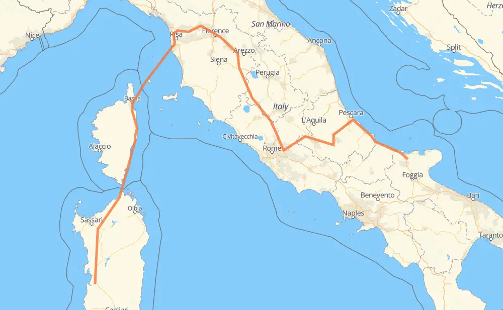
The distance from Terraba/Terralba to Apricena is 774 miles by road including 425 miles on motorways. Road takes approximately 18 hours and 44 minutes and goes through Livorno, Pisa, Lucques, Pistoia, Prato, Florence and Arezzo.
You can adjust fuel consumption and fuel price here.
How long is a car ride from Terraba/Terralba to Apricena?
Driving time:
18 h 44 min
This time is calculated for driving at the maximum permitted speed, taking into account traffic rules restrictions.
421 mi with a maximum speed 68 mph = 6 h 11 min
111 mi with a maximum speed 56 mph = 1 h 59 min
9 mi with a maximum speed 56 mph = 9 min
94 mi with a maximum speed 50 mph = 1 h 53 min
16 mi with a maximum speed 43 mph = 22 min
32 mi with a maximum speed 31 mph = 1 h 2 min
3 mi with a maximum speed 25 mph = 7 min
1 mi with a maximum speed 19 mph = 2 min
86 mi with a maximum speed 12 mph = 6 h 55 min
The calculated driving time does not take into account intermediate stops and traffic jams.
How far is Terraba/Terralba to Apricena by land?
The distance between Terraba/Terralba and Apricena is 773.6 mi by road including 425 mi on motorways.
Precise satellite coordinates of highways were used for this calculation. The start and finish points are the centers of Terraba/Terralba and Apricena respectively.
How far is Terraba/Terralba to Apricena by plane?
The shortest distance (air line, as the crow flies) between Terraba/Terralba and Apricena is 384 mi.
This distance is calculated using the Haversine formula as a great-circle distance between two points on the surface of a sphere. The start and finish points are the centers of Terraba/Terralba and Apricena respectively. Actual distance between airports may be different.
How many hours is Terraba/Terralba from Apricena by plane?
Boeing 737 airliner needs 46 min to cover the distance of 384 mi at a cruising speed of 497 mph.
Small plane "Cessna 172" needs 2 h 48 min to flight this distance at average speed of 136 mph.
This time is approximate and do not take into account takeoff and landing times, airport location and other real world factors.
How long is a helicopter ride from Terraba/Terralba to Apricena?
Fast helicopter "Eurocopter AS350" or "Hughes OH-6 Cayuse" need 2 h 34 min to cover the distance of 384 mi at a cruising speed of 149 mph.
Popular "Robinson R44" needs 2 h 56 min to flight this distance at average speed of 130 mph.
This time is approximate and do not take into account takeoff and landing times, aerodrome location and other real world factors.
What city is halfway between Terraba/Terralba and Apricena?
The halfway point between Terraba/Terralba and Apricena is Pistoia. It is located about 1 mi from the exact midpoint by road.
The distance from Pistoia to Terraba/Terralba is 386 mi and driving will take about 12 h 49 min. The road between Pistoia and Apricena has length 387 mi and will take approximately 5 h 55 min.
The other cities located close to halfway point:
Agliana is in 391 mi from Terraba/Terralba and 383 mi from Apricena
Serravalle Pistoiese is in 381 mi from Terraba/Terralba and 393 mi from Apricena
Prato is in 395 mi from Terraba/Terralba and 379 mi from Apricena
Where is Terraba/Terralba in relation to Apricena?
Terraba/Terralba is located 384 mi south-west of Apricena.
Terraba/Terralba has geographic coordinates: latitude 39.7203, longitude 8.63613.
Apricena has geographic coordinates: latitude 41.78394, longitude 15.44374.
Which highway goes from Terraba/Terralba to Apricena?
The route from Terraba/Terralba to Apricena follows A1, T 10, A14, SS131, A25.